CAMAREROOOO!!!!, PONGAME CINCO BARTOLOS

MTB
MTB
Ref..: 858868
Published: 14/02/2020
Performed: 14/02/2020
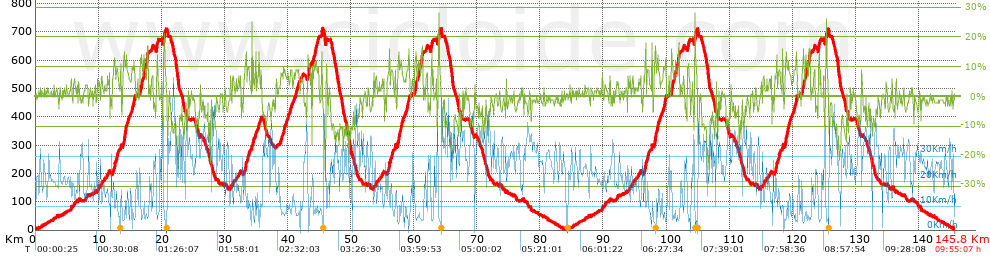
Distance in Km: 145.79
Climb in m: 3760
IBP: 272 BYC


 Height in m      Climb in %      Speed in Km/h      Speed < 2 Km/h

Climbs > 10%

Climbs >5% Climbs >10% Climbs >15% Climbs >20% Climbs >25%
 Steep slope of 901 m.   Average slope  Distances  Download as waypoint
1
 Km 12.443  13%  189 m
2
 Km 13.941  13%  321 m
3
 Km 14.371  12%  168 m
4
 Km 15.559  12%  223 m
 Steep slope of 768 m.  Average slope  Distances  Download as waypoint
5
 Km 16.622  13%  264 m
6
 Km 17.083  11%  285 m
7
 Km 17.67  13%  41 m
8
 Km 17.711  16%  178 m
 Steep slope of 184 m.  Average slope  Distances  Download as waypoint
9
 Km 19.152  12%  184 m
 Steep slope of 243 m.  Average slope  Distances  Download as waypoint
10
 Km 20.336  17%  243 m
 Steep slope of 394 m.  Average slope  Distances  Download as waypoint
11
 Km 33.253  13%  176 m
12
 Km 34.536  12%  107 m
13
 Km 35.397  13%  111 m
 Steep slope of 227 m.  Average slope  Distances  Download as waypoint
14
 Km 43.247  14%  227 m
 Steep slope of 442 m.  Average slope  Distances  Download as waypoint
15
 Km 44.08  13%  104 m
16
 Km 44.363  11%  187 m
17
 Km 45.358  15%  151 m
 Steep slope of 783 m.  Average slope  Distances  Download as waypoint
18
 Km 55.966  13%  149 m
19
 Km 57.471  13%  277 m
20
 Km 57.875  12%  179 m
21
 Km 59.073  13%  178 m
 Steep slope of 785 m.  Average slope  Distances  Download as waypoint
22
 Km 60.136  13%  277 m
23
 Km 60.604  11%  278 m
24
 Km 61.197  13%  32 m
25
 Km 61.229  16%  198 m
 Steep slope of 179 m.  Average slope  Distances  Download as waypoint
26
 Km 62.677  13%  179 m
 Steep slope of 228 m.  Average slope  Distances  Download as waypoint
27
 Km 63.881  20%  158 m
28
 Km 64.039  12%  70 m
 Steep slope of 954 m.  Average slope  Distances  Download as waypoint
29
 Km 96.61  13%  216 m
30
 Km 98.117  12%  515 m
31
 Km 99.768  12%  223 m
 Steep slope of 874 m.  Average slope  Distances  Download as waypoint
32
 Km 100.785  10%  46 m
33
 Km 100.831  14%  122 m
34
 Km 100.953  12%  183 m
35
 Km 101.256  10%  302 m
36
 Km 101.874  17%  188 m
37
 Km 102.062  13%  33 m
 Steep slope of 187 m.  Average slope  Distances  Download as waypoint
38
 Km 103.311  11%  187 m
 Steep slope of 224 m.  Average slope  Distances  Download as waypoint
39
 Km 104.51  18%  224 m
 Steep slope of 921 m.  Average slope  Distances  Download as waypoint
40
 Km 117.353  13%  235 m
41
 Km 118.849  13%  293 m
42
 Km 119.273  12%  162 m
43
 Km 120.477  12%  231 m
 Steep slope of 670 m.  Average slope  Distances  Download as waypoint
44
 Km 121.568  13%  255 m
45
 Km 121.996  11%  189 m
46
 Km 122.617  17%  190 m
47
 Km 122.807  12%  36 m
 Steep slope of 197 m.  Average slope  Distances  Download as waypoint
48
 Km 124.067  13%  197 m
 Steep slope of 207 m.  Average slope  Distances  Download as waypoint
49
 Km 125.272  24%  99 m
50
 Km 125.371  13%  108 m


Description of the route


Presence of ramps


 Climbs  Distance  % of the total  Speed  Your speed would be  Time  Your time would be
   15 - 30%  2.813  1.93  7.35  ?  0:22:57  ?
   10 - 15%  7.478  5.13  7.42  ?  1:00:26  ?
   5 - 10%  21.087  14.46  10.29  ?  2:02:59  ?
   1 - 5%  30.79  21.12  16.71  ?  1:50:35  ?
   Total*  62.167 Km  42.64 %  11.77 Km/h  ? Km/h    5:16:57 h  ? h  
 Flat
   1 - -1%  23.735 Km  16.28 %  19.85 Km/h  ? Km/h    1:11:44 h  ? h  
 Descents
   -1 - -5%  29.368  20.14  26.61  ?  1:06:13  ?
   -5 - -10%  19.271  13.22  29.23  ?  0:39:33  ?
   -10 - -15%  8.24  5.65  30.93  ?  0:15:59  ?
   -15 - -30%  3.01  2.06  22.82  ?  0:07:55  ?
   Total*  59.888 Km  41.08 %  27.71 Km/h  ? Km/h    2:09:40 h  ? h  
* The total has not necessarily coincide with the sum of the partials after correction of errors

How long would it take you?

How long would it take you to cover this route?
There are routes without a valid time information, but with your average stats you can assess the possible duration

Ant._Ariza_Obj._13000_Km to cover this route you've need a time of:   8:38:21 h 
If you sign in and have a minimum of two tracks of this same modality, you can know your time for this route, calculated from your stats..


¿Cuanto consumirá tu E-BIKE?

Entra tu E-IBP (formato n,nn)

E-IBP :   X 272 = 


 Detected activity type =  ()
 Penalization due to track conditions: 62 %   ( > 50 % = MTB, < 50 % = RDB)
 Reliability of the track: B   (3760/71/0/-/-/71)
 Correction level applied to the track: 0
DIFFICULTY OF THE ROUTE
IBP = 272 BYC
According to your statistics
 Your time in motion would be: ? h
Your average speed would be: ? Km/h
 

 Total Distance: 145.79 Km
 Analysed distance: 145.79 Km
 Linear distance: 0.08 Km

 Cumulated positive ramps: 3760 m  list of points info
 Cumulated negative ramps: 3752.9 m
 Maximum height: 710.8 m
 Minimum height: 3.2 m
 Climbing Ratio: 6.05 %
 Descent ratio: 6.27 %
 Cumulated postive ramps per Km: 25.79 m
 Cumulated negative ramps per Km: 25.74 m

 Total time: 9:55:07 h
 Time in movement: 8:38:21 h
 According to your statistics
 Your time in motion would be: ? h  
 Stopped time: 1:16:46 h
 Maximum slope filter: ~30 %
 Minimum separation analysed: ~30 m
 Number of points: 7725   (cad. 18.87 m)
 Significant waypoints: 3620   (cad. 40.27 m / 46.86 %)

 Changes in direction per Km: 9.71
 Changes in direction > 5º por Km: 6.54
 Cumulated straight stretches: 33.83 Km
 Straight stretches per Km: 232.05 m
 Penalized slope changes: 27
 Penalized slope changes per Km: 0.185

 Average speed in total: 14.7 Km/h
 Average speed while moving: 16.88 Km/h
 According to your statistics
 Your average speed would be: ? Km/h  
 Maximum sustained speed: 64.21 Km/h


Comments

You can be the first one in commenting this route

 
My comments
:
Add comment  (Registered users)
 
Notify me answers to my comment  Do not notify answers to my comment


Share this route with a friend

Your friend will receive a message with a link to this page:
will see your email and your user name if you do it as registered user.


Write here your name (optional)

E-mail address of your friend(s). You can include various addresses separated by commas

Text or comment (optional) maximum 255 characters long, 255 Available characters

As a non registered users you need to fill-in the captcha text.
  Change image
Type the image characters.
 
 Share with a friend


Visited history

Delete history

Marked routes for review later or compare

My favorites


  Notify anomaly in this route Share in Facebook