Alcanar (Tarragona)

Road
Road
Ref..: 848583
Published: 07/12/2019
Performed: 07/12/2019
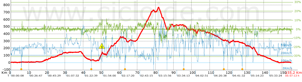
Distance in Km: 155.18
Climb in m: 1661
IBP: 136 BYC

Luis García Landa
710 published routes

Add to my Group or Club

 Height in m      Climb in %      Speed in Km/h      Speed < 2 Km/h

Climbs > 5%

Climbs >5% Climbs >10% Climbs >15% Climbs >20% Climbs >25%
 Steep slope of 393 m.   Average slope  Distances  Download as waypoint
1
 Km 48.788  7%  393 m
 Steep slope of 285 m.  Average slope  Distances  Download as waypoint
2
 Km 49.481  7%  285 m
 Steep slope of 96 m.  Average slope  Distances  Download as waypoint
3
 Km 50.023  5%  96 m
 Steep slope of 359 m.  Average slope  Distances  Download as waypoint
4
 Km 50.207  7%  189 m
5
 Km 50.396  10%  131 m
6
 Km 50.528  11%  39 m
 Steep slope of 569 m.  Average slope  Distances  Download as waypoint
7
 Km 52.889  7%  569 m
 Steep slope of 97 m.  Average slope  Distances  Download as waypoint
8
 Km 53.558  7%  97 m
 Steep slope of 455 m.  Average slope  Distances  Download as waypoint
9
 Km 54.167  6%  455 m
 Steep slope of 222 m.  Average slope  Distances  Download as waypoint
10
 Km 55.357  6%  222 m
 Steep slope of 371 m.  Average slope  Distances  Download as waypoint
11
 Km 57.077  6%  371 m
 Steep slope of 155 m.  Average slope  Distances  Download as waypoint
12
 Km 58.495  6%  155 m
 Steep slope of 140 m.  Average slope  Distances  Download as waypoint
13
 Km 59.157  6%  140 m
 Steep slope of 382 m.  Average slope  Distances  Download as waypoint
14
 Km 60.207  5%  382 m
 Steep slope of 250 m.  Average slope  Distances  Download as waypoint
15
 Km 70.041  5%  250 m
 Steep slope of 326 m.  Average slope  Distances  Download as waypoint
16
 Km 70.678  6%  326 m
 Steep slope of 97 m.  Average slope  Distances  Download as waypoint
17
 Km 71.134  6%  97 m
 Steep slope of 159 m.  Average slope  Distances  Download as waypoint
18
 Km 71.514  6%  159 m
 Steep slope of 228 m.  Average slope  Distances  Download as waypoint
19
 Km 71.781  5%  228 m
 Steep slope of 139 m.  Average slope  Distances  Download as waypoint
20
 Km 72.182  5%  139 m
 Steep slope of 169 m.  Average slope  Distances  Download as waypoint
21
 Km 72.553  6%  169 m
 Steep slope of 231 m.  Average slope  Distances  Download as waypoint
22
 Km 73.026  5%  231 m
 Steep slope of 312 m.  Average slope  Distances  Download as waypoint
23
 Km 73.59  6%  312 m
 Steep slope of 592 m.  Average slope  Distances  Download as waypoint
24
 Km 74.136  7%  592 m
 Steep slope of 221 m.  Average slope  Distances  Download as waypoint
25
 Km 74.847  6%  221 m
 Steep slope of 135 m.  Average slope  Distances  Download as waypoint
26
 Km 75.235  5%  135 m
 Steep slope of 104 m.  Average slope  Distances  Download as waypoint
27
 Km 75.64  5%  104 m
 Steep slope of 253 m.  Average slope  Distances  Download as waypoint
28
 Km 76.083  7%  253 m
 Steep slope of 187 m.  Average slope  Distances  Download as waypoint
29
 Km 76.437  6%  187 m
 Steep slope of 463 m.  Average slope  Distances  Download as waypoint
30
 Km 77.1  7%  463 m
 Steep slope of 117 m.  Average slope  Distances  Download as waypoint
31
 Km 77.743  6%  117 m
 Steep slope of 296 m.  Average slope  Distances  Download as waypoint
32
 Km 80.764  6%  296 m
 Steep slope of 296 m.  Average slope  Distances  Download as waypoint
33
 Km 81.213  7%  296 m
 Steep slope of 411 m.  Average slope  Distances  Download as waypoint
34
 Km 87.646  6%  411 m
 Steep slope of 280 m.  Average slope  Distances  Download as waypoint
35
 Km 88.229  6%  280 m
 Steep slope of 115 m.  Average slope  Distances  Download as waypoint
36
 Km 99.356  7%  115 m
 Steep slope of 744 m.  Average slope  Distances  Download as waypoint
37
 Km 102.929  7%  744 m
 Steep slope of 176 m.  Average slope  Distances  Download as waypoint
38
 Km 133.81  6%  176 m


Description of the route


Presence of ramps


 Climbs  Distance  % of the total  Speed  Your speed would be  Time  Your time would be
   15 - 30%  0  0  0  ?  0:00:00  ?
   10 - 15%  0.204  0.13  14.1  ?  0:00:52  ?
   5 - 10%  11.304  7.28  17.89  ?  0:37:55  ?
   1 - 5%  37.448  24.13  25.26  ?  1:28:57  ?
   Total*  48.955 Km  31.55 %  23 Km/h  ? Km/h    2:07:44 h  ? h  
 Flat
   1 - -1%  52.982 Km  34.14 %  32.6 Km/h  ? Km/h    1:37:30 h  ? h  
 Descents
   -1 - -5%  44.306  28.55  37.91  ?  1:10:07  ?
   -5 - -10%  8.215  5.29  46.07  ?  0:10:42  ?
   -10 - -15%  0.606  0.39  23.45  ?  0:01:33  ?
   -15 - -30%  0.112  0.07  40.22  ?  0:00:10  ?
   Total*  53.238 Km  34.31 %  38.7 Km/h  ? Km/h    1:22:32 h  ? h  
* The total has not necessarily coincide with the sum of the partials after correction of errors

How long would it take you?

How long would it take you to cover this route?
There are routes without a valid time information, but with your average stats you can assess the possible duration

Luis García Landa to cover this route you've need a time of:   5:07:46 h 
If you sign in and have a minimum of two tracks of this same modality, you can know your time for this route, calculated from your stats..


¿Cuanto consumirá tu E-BIKE?

Entra tu E-IBP (formato n,nn)

E-IBP :   X 136 = 


 Detected activity type =  ()
 Penalization due to track conditions: 31 %   ( > 50 % = MTB, < 50 % = RDB)
 Reliability of the track: C   (1661/52/0/-/-/52)
 Correction level applied to the track: 0
DIFFICULTY OF THE ROUTE
IBP = 136 BYC
According to your statistics
 Your time in motion would be: ? h
Your average speed would be: ? Km/h
 

 Total Distance: 155.18 Km
 Analysed distance: 155.18 Km
 Linear distance: 0.02 Km

 Cumulated positive ramps: 1661 m  list of points info
 Cumulated negative ramps: 1658 m
 Maximum height: 769.6 m
 Minimum height: -2.4 m
 Climbing Ratio: 3.39 %
 Descent ratio: 3.11 %
 Cumulated postive ramps per Km: 10.7 m
 Cumulated negative ramps per Km: 10.68 m

 Total time: 5:57:13 h
 Time in movement: 5:07:46 h
 According to your statistics
 Your time in motion would be: ? h  
 Stopped time: 0:49:27 h
 Maximum slope filter: ~30 %
 Minimum separation analysed: ~30 m
 Number of points: 11143   (cad. 13.93 m)
 Significant waypoints: 4412   (cad. 35.17 m / 39.59 %)

 Changes in direction per Km: 7.26
 Changes in direction > 5º por Km: 2.11
 Cumulated straight stretches: 97.319 Km
 Straight stretches per Km: 627.14 m
 Penalized slope changes: 15
 Penalized slope changes per Km: 0.097

 Average speed in total: 26.06 Km/h
 Average speed while moving: 30.25 Km/h
 According to your statistics
 Your average speed would be: ? Km/h  
 Maximum sustained speed: 67.17 Km/h


Comments

You can be the first one in commenting this route

 
My comments
:
Add comment  (Registered users)
 
Notify me answers to my comment  Do not notify answers to my comment


Share this route with a friend

Your friend will receive a message with a link to this page:
will see your email and your user name if you do it as registered user.


Write here your name (optional)

E-mail address of your friend(s). You can include various addresses separated by commas

Text or comment (optional) maximum 255 characters long, 255 Available characters

As a non registered users you need to fill-in the captcha text.
  Change image
Type the image characters.
 
 Share with a friend


Visited history

Delete history

Marked routes for review later or compare

My favorites


  Notify anomaly in this route Share in Facebook