09/11/2019 Carniglia

MTB
MTB
Ref..: 846021
Published: 09/11/2019
Performed: 09/11/2019
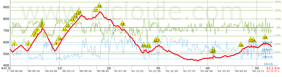
Distance in Km: 53.07
Climb in m: 1016
IBP: 66 BYC

Spagnoli_Mauro_Lambro
1058 published routes

Add to my Group or Club

 Height in m      Climb in %      Speed in Km/h      Speed < 2 Km/h

Climbs > 5%

Climbs >5% Climbs >10% Climbs >15% Climbs >20% Climbs >25%
 Steep slope of 158 m.   Average slope  Distances  Download as waypoint
1
 Km 0.873  5%  158 m
 Steep slope of 1037 m.  Average slope  Distances  Download as waypoint
2
 Km 3.642  7%  1037 m
 Steep slope of 209 m.  Average slope  Distances  Download as waypoint
3
 Km 4.779  7%  209 m
 Steep slope of 312 m.  Average slope  Distances  Download as waypoint
4
 Km 5.091  6%  312 m
 Steep slope of 279 m.  Average slope  Distances  Download as waypoint
5
 Km 5.51  6%  279 m
 Steep slope of 378 m.  Average slope  Distances  Download as waypoint
6
 Km 6.221  9%  169 m
7
 Km 6.39  9%  107 m
8
 Km 6.497  11%  102 m
 Steep slope of 348 m.  Average slope  Distances  Download as waypoint
9
 Km 9.389  9%  348 m
 Steep slope of 924 m.  Average slope  Distances  Download as waypoint
10
 Km 9.842  7%  924 m
 Steep slope of 338 m.  Average slope  Distances  Download as waypoint
11
 Km 11.026  8%  338 m
 Steep slope of 429 m.  Average slope  Distances  Download as waypoint
12
 Km 11.685  6%  429 m
 Steep slope of 299 m.  Average slope  Distances  Download as waypoint
13
 Km 12.549  6%  299 m
 Steep slope of 292 m.  Average slope  Distances  Download as waypoint
14
 Km 13.125  5%  292 m
 Steep slope of 189 m.  Average slope  Distances  Download as waypoint
15
 Km 13.707  6%  189 m
 Steep slope of 328 m.  Average slope  Distances  Download as waypoint
16
 Km 14.003  6%  328 m
 Steep slope of 180 m.  Average slope  Distances  Download as waypoint
17
 Km 17.362  6%  180 m
 Steep slope of 146 m.  Average slope  Distances  Download as waypoint
18
 Km 18.035  6%  146 m
 Steep slope of 110 m.  Average slope  Distances  Download as waypoint
19
 Km 22.748  5%  110 m
 Steep slope of 217 m.  Average slope  Distances  Download as waypoint
20
 Km 27.037  8%  217 m
 Steep slope of 142 m.  Average slope  Distances  Download as waypoint
21
 Km 28.026  7%  142 m
 Steep slope of 111 m.  Average slope  Distances  Download as waypoint
22
 Km 29.449  5%  111 m
 Steep slope of 115 m.  Average slope  Distances  Download as waypoint
23
 Km 29.859  5%  115 m
 Steep slope of 136 m.  Average slope  Distances  Download as waypoint
24
 Km 41.062  11%  101 m
25
 Km 41.164  9%  35 m
 Steep slope of 340 m.  Average slope  Distances  Download as waypoint
26
 Km 46.748  7%  340 m
 Steep slope of 148 m.  Average slope  Distances  Download as waypoint
27
 Km 48.718  7%  148 m
 Steep slope of 153 m.  Average slope  Distances  Download as waypoint
28
 Km 49.289  6%  153 m
 Steep slope of 103 m.  Average slope  Distances  Download as waypoint
29
 Km 51.663  9%  103 m


Description of the route


Presence of ramps


 Climbs  Distance  % of the total  Speed  Your speed would be  Time  Your time would be
   15 - 30%  0  0  0  ?  0:00:00  ?
   10 - 15%  0.752  1.42  11.33  ?  0:03:59  ?
   5 - 10%  10.086  19.01  14.61  ?  0:41:26  ?
   1 - 5%  8.287  15.62  18.7  ?  0:26:35  ?
   Total*  19.126 Km  36.04 %  15.94 Km/h  ? Km/h    1:12:00 h  ? h  
 Flat
   1 - -1%  14.697 Km  27.7 %  24.47 Km/h  ? Km/h    0:36:02 h  ? h  
 Descents
   -1 - -5%  10.044  18.93  33.05  ?  0:18:14  ?
   -5 - -10%  8.261  15.57  33.61  ?  0:14:45  ?
   -10 - -15%  0.938  1.77  31.86  ?  0:01:46  ?
   -15 - -30%  0  0  0  ?  0:00:00  ?
   Total*  19.244 Km  36.26 %  33.23 Km/h  ? Km/h    0:34:45 h  ? h  
* The total has not necessarily coincide with the sum of the partials after correction of errors

How long would it take you?

How long would it take you to cover this route?
There are routes without a valid time information, but with your average stats you can assess the possible duration

Spagnoli_Mauro_Lambro to cover this route you've need a time of:   2:22:47 h 
If you sign in and have a minimum of two tracks of this same modality, you can know your time for this route, calculated from your stats..


¿Cuanto consumirá tu E-BIKE?

Entra tu E-IBP (formato n,nn)

E-IBP :   X 66 = 


 Detected activity type =  ()
 Penalization due to track conditions: 63 %   ( > 50 % = MTB, < 50 % = RDB)
 Reliability of the track: A   (1016/79/0/-/-/79)
 Correction level applied to the track: 0
DIFFICULTY OF THE ROUTE
IBP = 66 BYC
According to your statistics
 Your time in motion would be: ? h
Your average speed would be: ? Km/h
 

 Total Distance: 53.07 Km
 Analysed distance: 53.07 Km
 Linear distance: 0.24 Km

 Cumulated positive ramps: 1015.8 m  list of points info
 Cumulated negative ramps: 995.2 m
 Maximum height: 861.6 m
 Minimum height: 441.6 m
 Climbing Ratio: 5.31 %
 Descent ratio: 5.17 %
 Cumulated postive ramps per Km: 19.14 m
 Cumulated negative ramps per Km: 18.75 m

 Total time: 2:22:47 h
 Time in movement: 2:22:47 h
 According to your statistics
 Your time in motion would be: ? h  
 Stopped time: 0:00:00 h
 Maximum slope filter: ~30 %
 Minimum separation analysed: ~30 m
 Number of points: 3969   (cad. 13.37 m)
 Significant waypoints: 1494   (cad. 35.52 m / 37.64 %)

 Changes in direction per Km: 9.7
 Changes in direction > 5º por Km: 6.22
 Cumulated straight stretches: 12.357 Km
 Straight stretches per Km: 232.84 m
 Penalized slope changes: 8
 Penalized slope changes per Km: 0.151

 Average speed in total: 22.3 Km/h
 Average speed while moving: 22.3 Km/h
 According to your statistics
 Your average speed would be: ? Km/h  
 Maximum sustained speed: 46.4 Km/h


Comments

You can be the first one in commenting this route

 
My comments
:
Add comment  (Registered users)
 
Notify me answers to my comment  Do not notify answers to my comment


Share this route with a friend

Your friend will receive a message with a link to this page:
will see your email and your user name if you do it as registered user.


Write here your name (optional)

E-mail address of your friend(s). You can include various addresses separated by commas

Text or comment (optional) maximum 255 characters long, 255 Available characters

As a non registered users you need to fill-in the captcha text.
  Change image
Type the image characters.
 
 Share with a friend


Visited history

Delete history

Marked routes for review later or compare

My favorites


  Notify anomaly in this route Share in Facebook