Huetor Vega (Granada)

MTB
MTB
Ref..: 845696
Published: 31/10/2019
Performed: 31/10/2019
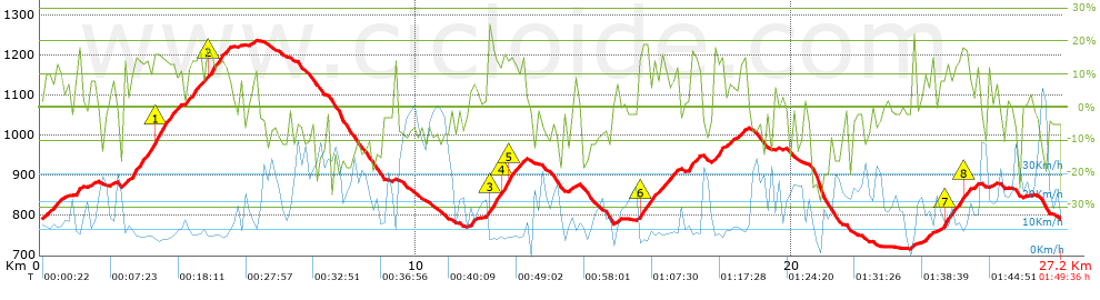
Distance in Km: 27.2
Climb in m: 1140
IBP: 119 BYC

Near ...
Barrio De La Vega, Barrio De Monachil, Cajar, Cenes De La Vega, Huetor Vega, Monachil
fernan2g
Author: fernan2g
1943 published routes

Add to my Group or Club

 Height in m      Climb in %      Speed in Km/h      Speed < 2 Km/h

Climbs > 5%

Climbs >5% Climbs >10% Climbs >15% Climbs >20% Climbs >25%
 Steep slope of 628 m.   Average slope  Distances  Download as waypoint
1
 Km 0.092  9%  174 m
2
 Km 0.266  8%  145 m
3
 Km 0.412  8%  309 m
 Steep slope of 176 m.  Average slope  Distances  Download as waypoint
4
 Km 0.949  13%  176 m
 Steep slope of 111 m.  Average slope  Distances  Download as waypoint
5
 Km 1.346  9%  111 m
 Steep slope of 124 m.  Average slope  Distances  Download as waypoint
6
 Km 1.876  8%  124 m
 Steep slope of 1529 m.  Average slope  Distances  Download as waypoint
7
 Km 2.191  9%  272 m
8
 Km 2.464  14%  563 m
9
 Km 3.027  17%  242 m
10
 Km 3.268  14%  257 m
11
 Km 3.526  10%  195 m
 Steep slope of 1164 m.  Average slope  Distances  Download as waypoint
12
 Km 3.863  9%  39 m
13
 Km 3.902  12%  335 m
14
 Km 4.237  8%  211 m
15
 Km 4.447  16%  109 m
16
 Km 4.557  13%  470 m
 Steep slope of 158 m.  Average slope  Distances  Download as waypoint
17
 Km 5.605  7%  158 m
 Steep slope of 163 m.  Average slope  Distances  Download as waypoint
18
 Km 11.459  10%  163 m
 Steep slope of 1038 m.  Average slope  Distances  Download as waypoint
19
 Km 11.907  6%  38 m
20
 Km 11.945  19%  177 m
21
 Km 12.123  12%  147 m
22
 Km 12.269  16%  126 m
23
 Km 12.395  14%  108 m
24
 Km 12.503  17%  109 m
25
 Km 12.612  11%  160 m
26
 Km 12.772  10%  173 m
 Steep slope of 113 m.  Average slope  Distances  Download as waypoint
27
 Km 14.202  8%  113 m
 Steep slope of 1097 m.  Average slope  Distances  Download as waypoint
28
 Km 15.929  13%  75 m
29
 Km 16.004  16%  113 m
30
 Km 16.117  12%  230 m
31
 Km 16.347  10%  186 m
32
 Km 16.533  13%  128 m
33
 Km 16.661  10%  248 m
34
 Km 16.909  12%  117 m
 Steep slope of 332 m.  Average slope  Distances  Download as waypoint
35
 Km 17.258  12%  220 m
36
 Km 17.478  12%  112 m
 Steep slope of 501 m.  Average slope  Distances  Download as waypoint
37
 Km 17.93  13%  211 m
38
 Km 18.141  8%  154 m
39
 Km 18.295  10%  100 m
40
 Km 18.395  10%  36 m
 Steep slope of 193 m.  Average slope  Distances  Download as waypoint
41
 Km 18.593  7%  46 m
42
 Km 18.639  14%  113 m
43
 Km 18.751  6%  34 m
 Steep slope of 98 m.  Average slope  Distances  Download as waypoint
44
 Km 23.215  15%  98 m
 Steep slope of 217 m.  Average slope  Distances  Download as waypoint
45
 Km 23.537  10%  175 m
46
 Km 23.712  15%  42 m
 Steep slope of 851 m.  Average slope  Distances  Download as waypoint
47
 Km 23.911  7%  146 m
48
 Km 24.057  17%  107 m
49
 Km 24.163  11%  143 m
50
 Km 24.307  13%  112 m
51
 Km 24.419  12%  125 m
52
 Km 24.544  18%  107 m
53
 Km 24.651  11%  82 m
54
 Km 24.733  8%  29 m
 Steep slope of 138 m.  Average slope  Distances  Download as waypoint
55
 Km 25.238  5%  138 m


Description of the route


Presence of ramps


 Climbs  Distance  % of the total  Speed  Your speed would be  Time  Your time would be
   15 - 30%  1.817  6.68  8.6  ?  0:12:41  ?
   10 - 15%  4.015  14.76  9.74  ?  0:24:44  ?
   5 - 10%  3.312  12.18  12.18  ?  0:16:19  ?
   1 - 5%  2.408  8.85  14.77  ?  0:09:47  ?
   Total*  11.551 Km  42.47 %  10.91 Km/h  ? Km/h    1:03:31 h  ? h  
 Flat
   1 - -1%  2.501 Km  9.2 %  19.16 Km/h  ? Km/h    0:07:50 h  ? h  
 Descents
   -1 - -5%  4.526  16.64  20.34  ?  0:13:21  ?
   -5 - -10%  3.907  14.36  29.86  ?  0:07:51  ?
   -10 - -15%  2.549  9.37  23.9  ?  0:06:24  ?
   -15 - -30%  2.164  7.95  14.29  ?  0:09:05  ?
   Total*  13.145 Km  48.33 %  21.5 Km/h  ? Km/h    0:36:41 h  ? h  
* The total has not necessarily coincide with the sum of the partials after correction of errors

How long would it take you?

How long would it take you to cover this route?
There are routes without a valid time information, but with your average stats you can assess the possible duration

fernan2g to cover this route you've need a time of:   1:48:02 h 
If you sign in and have a minimum of two tracks of this same modality, you can know your time for this route, calculated from your stats..


¿Cuanto consumirá tu E-BIKE?

Entra tu E-IBP (formato n,nn)

E-IBP :   X 119 = 


 Detected activity type =  ()
 Penalization due to track conditions: 59 %   ( > 50 % = MTB, < 50 % = RDB)
 Reliability of the track: A   (1140/80/0/-/-/80)
 Correction level applied to the track: 0
DIFFICULTY OF THE ROUTE
IBP = 119 BYC
According to your statistics
 Your time in motion would be: ? h
Your average speed would be: ? Km/h
 

 Total Distance: 27.2 Km
 Analysed distance: 27.2 Km
 Linear distance: 0.01 Km

 Cumulated positive ramps: 1140.4 m  list of points info
 Cumulated negative ramps: 1142.2 m
 Maximum height: 1236.8 m
 Minimum height: 714.8 m
 Climbing Ratio: 9.87 %
 Descent ratio: 8.69 %
 Cumulated postive ramps per Km: 41.93 m
 Cumulated negative ramps per Km: 41.99 m

 Total time: 1:49:36 h
 Time in movement: 1:48:02 h
 According to your statistics
 Your time in motion would be: ? h  
 Stopped time: 0:01:34 h
 Maximum slope filter: ~30 %
 Minimum separation analysed: ~30 m
 Number of points: 1648   (cad. 16.5 m)
 Significant waypoints: 714   (cad. 38.09 m / 43.33 %)

 Changes in direction per Km: 12.72
 Changes in direction > 5º por Km: 10.74
 Cumulated straight stretches: 2.78 Km
 Straight stretches per Km: 102.21 m
 Penalized slope changes: 10
 Penalized slope changes per Km: 0.368

 Average speed in total: 14.89 Km/h
 Average speed while moving: 15.11 Km/h
 According to your statistics
 Your average speed would be: ? Km/h  
 Maximum sustained speed: 62.35 Km/h


Comments

You can be the first one in commenting this route

 
My comments
:
Add comment  (Registered users)
 
Notify me answers to my comment  Do not notify answers to my comment


Share this route with a friend

Your friend will receive a message with a link to this page:
will see your email and your user name if you do it as registered user.


Write here your name (optional)

E-mail address of your friend(s). You can include various addresses separated by commas

Text or comment (optional) maximum 255 characters long, 255 Available characters

As a non registered users you need to fill-in the captcha text.
  Change image
Type the image characters.
 
 Share with a friend


Visited history

Delete history

Marked routes for review later or compare

My favorites


  Notify anomaly in this route Share in Facebook