Torres Vedras (Resende)

MTB
MTB
Ref..: 845671
Published: 30/10/2019
Performed: 30/10/2019
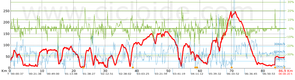
Distance in Km: 86.83
Climb in m: 1480
IBP: 121 BYC


 Height in m      Climb in %      Speed in Km/h      Speed < 2 Km/h

Climbs > 5%

Climbs >5% Climbs >10% Climbs >15% Climbs >20% Climbs >25%
 Steep slope of 308 m.   Average slope  Distances  Download as waypoint
1
 Km 0.701  6%  243 m
2
 Km 0.944  12%  65 m
 Steep slope of 138 m.  Average slope  Distances  Download as waypoint
3
 Km 2.11  9%  138 m
 Steep slope of 463 m.  Average slope  Distances  Download as waypoint
4
 Km 8.536  13%  203 m
5
 Km 8.739  8%  260 m
 Steep slope of 135 m.  Average slope  Distances  Download as waypoint
6
 Km 9.131  10%  135 m
 Steep slope of 131 m.  Average slope  Distances  Download as waypoint
7
 Km 15.627  10%  131 m
 Steep slope of 104 m.  Average slope  Distances  Download as waypoint
8
 Km 15.943  5%  104 m
 Steep slope of 334 m.  Average slope  Distances  Download as waypoint
9
 Km 16.185  11%  200 m
10
 Km 16.385  10%  134 m
 Steep slope of 630 m.  Average slope  Distances  Download as waypoint
11
 Km 23.42  7%  99 m
12
 Km 23.519  16%  266 m
13
 Km 23.784  6%  265 m
 Steep slope of 432 m.  Average slope  Distances  Download as waypoint
14
 Km 26.341  8%  132 m
15
 Km 26.472  13%  102 m
16
 Km 26.575  9%  198 m
 Steep slope of 108 m.  Average slope  Distances  Download as waypoint
17
 Km 28.039  6%  108 m
 Steep slope of 238 m.  Average slope  Distances  Download as waypoint
18
 Km 30.652  9%  33 m
19
 Km 30.685  15%  170 m
20
 Km 30.854  14%  35 m
 Steep slope of 383 m.  Average slope  Distances  Download as waypoint
21
 Km 33.592  5%  383 m
 Steep slope of 178 m.  Average slope  Distances  Download as waypoint
22
 Km 34.719  6%  178 m
 Steep slope of 174 m.  Average slope  Distances  Download as waypoint
23
 Km 35.038  6%  174 m
 Steep slope of 757 m.  Average slope  Distances  Download as waypoint
24
 Km 37.964  6%  32 m
25
 Km 37.996  13%  169 m
26
 Km 38.164  12%  97 m
27
 Km 38.262  11%  261 m
28
 Km 38.523  8%  198 m
 Steep slope of 139 m.  Average slope  Distances  Download as waypoint
29
 Km 38.891  5%  139 m
 Steep slope of 149 m.  Average slope  Distances  Download as waypoint
30
 Km 41.621  5%  149 m
 Steep slope of 542 m.  Average slope  Distances  Download as waypoint
31
 Km 45.962  7%  542 m
 Steep slope of 171 m.  Average slope  Distances  Download as waypoint
32
 Km 48.033  9%  171 m
 Steep slope of 137 m.  Average slope  Distances  Download as waypoint
33
 Km 48.677  9%  137 m
 Steep slope of 90 m.  Average slope  Distances  Download as waypoint
34
 Km 53.392  9%  90 m
 Steep slope of 733 m.  Average slope  Distances  Download as waypoint
35
 Km 54.143  7%  95 m
36
 Km 54.238  18%  170 m
37
 Km 54.407  9%  99 m
38
 Km 54.507  9%  101 m
39
 Km 54.608  10%  268 m
 Steep slope of 97 m.  Average slope  Distances  Download as waypoint
40
 Km 55.362  6%  97 m
 Steep slope of 278 m.  Average slope  Distances  Download as waypoint
41
 Km 58.53  6%  278 m
 Steep slope of 342 m.  Average slope  Distances  Download as waypoint
42
 Km 62.302  8%  342 m
 Steep slope of 135 m.  Average slope  Distances  Download as waypoint
43
 Km 62.752  6%  135 m
 Steep slope of 145 m.  Average slope  Distances  Download as waypoint
44
 Km 63.255  5%  145 m
 Steep slope of 308 m.  Average slope  Distances  Download as waypoint
45
 Km 63.54  9%  67 m
46
 Km 63.607  11%  102 m
47
 Km 63.709  7%  139 m
 Steep slope of 148 m.  Average slope  Distances  Download as waypoint
48
 Km 63.985  5%  148 m
 Steep slope of 236 m.  Average slope  Distances  Download as waypoint
49
 Km 65.087  9%  236 m
 Steep slope of 106 m.  Average slope  Distances  Download as waypoint
50
 Km 66.226  15%  106 m
 Steep slope of 205 m.  Average slope  Distances  Download as waypoint
51
 Km 66.436  17%  102 m
52
 Km 66.538  8%  103 m
 Steep slope of 201 m.  Average slope  Distances  Download as waypoint
53
 Km 66.778  10%  201 m
 Steep slope of 129 m.  Average slope  Distances  Download as waypoint
54
 Km 67.228  11%  129 m
 Steep slope of 99 m.  Average slope  Distances  Download as waypoint
55
 Km 67.476  9%  99 m
 Steep slope of 130 m.  Average slope  Distances  Download as waypoint
56
 Km 68.044  11%  130 m
 Steep slope of 623 m.  Average slope  Distances  Download as waypoint
57
 Km 68.455  8%  623 m
 Steep slope of 231 m.  Average slope  Distances  Download as waypoint
58
 Km 69.32  6%  231 m
 Steep slope of 166 m.  Average slope  Distances  Download as waypoint
59
 Km 69.656  7%  166 m
 Steep slope of 124 m.  Average slope  Distances  Download as waypoint
60
 Km 83.765  26%  124 m


Description of the route


Presence of ramps


 Climbs  Distance  % of the total  Speed  Your speed would be  Time  Your time would be
   15 - 30%  0.903  1.04  6.9  ?  0:07:51  ?
   10 - 15%  2.438  2.81  6.8  ?  0:21:30  ?
   5 - 10%  9.368  10.79  9.55  ?  0:58:52  ?
   1 - 5%  12.406  14.29  13.3  ?  0:55:57  ?
   Total*  25.114 Km  28.92 %  10.45 Km/h  ? Km/h    2:24:10 h  ? h  
 Flat
   1 - -1%  33.5 Km  38.58 %  18.21 Km/h  ? Km/h    1:50:22 h  ? h  
 Descents
   -1 - -5%  16.401  18.89  22.16  ?  0:44:24  ?
   -5 - -10%  9.038  10.41  23.98  ?  0:22:37  ?
   -10 - -15%  2.031  2.34  23.06  ?  0:05:17  ?
   -15 - -30%  0.768  0.88  28.78  ?  0:01:36  ?
   Total*  28.237 Km  32.52 %  22.93 Km/h  ? Km/h    1:13:54 h  ? h  
* The total has not necessarily coincide with the sum of the partials after correction of errors

How long would it take you?

How long would it take you to cover this route?
There are routes without a valid time information, but with your average stats you can assess the possible duration

Angel Del Gallo Fernandez to cover this route you've need a time of:   5:28:26 h 
If you sign in and have a minimum of two tracks of this same modality, you can know your time for this route, calculated from your stats..


¿Cuanto consumirá tu E-BIKE?

Entra tu E-IBP (formato n,nn)

E-IBP :   X 121 = 


 Detected activity type =  ()
 Penalization due to track conditions: 62 %   ( > 50 % = MTB, < 50 % = RDB)
 Reliability of the track: B   (1480/68/0/-/-/68)
 Correction level applied to the track: 0
DIFFICULTY OF THE ROUTE
IBP = 121 BYC
According to your statistics
 Your time in motion would be: ? h
Your average speed would be: ? Km/h
 

 Total Distance: 86.83 Km
 Analysed distance: 86.83 Km
 Linear distance: 47.63 Km

 Cumulated positive ramps: 1479.7 m  list of points info
 Cumulated negative ramps: 1465.9 m
 Maximum height: 246.9 m
 Minimum height: 3.8 m
 Climbing Ratio: 5.89 %
 Descent ratio: 5.19 %
 Cumulated postive ramps per Km: 17.04 m
 Cumulated negative ramps per Km: 16.88 m

 Total time: 8:08:20 h
 Time in movement: 5:28:26 h
 According to your statistics
 Your time in motion would be: ? h  
 Stopped time: 2:39:54 h
 Maximum slope filter: ~30 %
 Minimum separation analysed: ~30 m
 Number of points: 6800   (cad. 12.77 m)
 Significant waypoints: 2408   (cad. 36.08 m / 35.41 %)

 Changes in direction per Km: 9.08
 Changes in direction > 5º por Km: 5.3
 Cumulated straight stretches: 28.701 Km
 Straight stretches per Km: 330.54 m
 Penalized slope changes: 18
 Penalized slope changes per Km: 0.207

 Average speed in total: 10.67 Km/h
 Average speed while moving: 15.86 Km/h
 According to your statistics
 Your average speed would be: ? Km/h  
 Maximum sustained speed: 58.18 Km/h


Comments

You can be the first one in commenting this route

 
My comments
:
Add comment  (Registered users)
 
Notify me answers to my comment  Do not notify answers to my comment


Share this route with a friend

Your friend will receive a message with a link to this page:
will see your email and your user name if you do it as registered user.


Write here your name (optional)

E-mail address of your friend(s). You can include various addresses separated by commas

Text or comment (optional) maximum 255 characters long, 255 Available characters

As a non registered users you need to fill-in the captcha text.
  Change image
Type the image characters.
 
 Share with a friend


Visited history

Delete history

Marked routes for review later or compare

My favorites


  Notify anomaly in this route Share in Facebook