Madre mía, 24° a las 6h. El campo está frito _. Seguimos subiendo cuestas ____

MTB
MTB
Ref..: 841972
Published: 10/10/2019
Performed: 08/10/2019
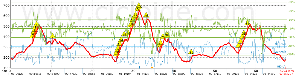
Distance in Km: 67.32
Climb in m: 1912
IBP: 140 BYC


 Height in m      Climb in %      Speed in Km/h      Speed < 2 Km/h

Climbs > 5%

Climbs >5% Climbs >10% Climbs >15% Climbs >20% Climbs >25%
 Steep slope of 445 m.   Average slope  Distances  Download as waypoint
1
 Km 0.732  6%  445 m
 Steep slope of 363 m.  Average slope  Distances  Download as waypoint
2
 Km 3.563  8%  363 m
 Steep slope of 122 m.  Average slope  Distances  Download as waypoint
3
 Km 4.58  5%  122 m
 Steep slope of 1445 m.  Average slope  Distances  Download as waypoint
4
 Km 5.325  9%  76 m
5
 Km 5.401  11%  75 m
6
 Km 5.476  18%  141 m
7
 Km 5.617  11%  275 m
8
 Km 5.892  11%  144 m
9
 Km 6.036  11%  103 m
10
 Km 6.139  8%  188 m
11
 Km 6.327  10%  222 m
12
 Km 6.549  7%  221 m
 Steep slope of 145 m.  Average slope  Distances  Download as waypoint
13
 Km 6.898  7%  145 m
 Steep slope of 222 m.  Average slope  Distances  Download as waypoint
14
 Km 10.233  7%  30 m
15
 Km 10.263  14%  102 m
16
 Km 10.365  6%  90 m
 Steep slope of 187 m.  Average slope  Distances  Download as waypoint
17
 Km 10.617  7%  187 m
 Steep slope of 196 m.  Average slope  Distances  Download as waypoint
18
 Km 11.753  10%  196 m
 Steep slope of 152 m.  Average slope  Distances  Download as waypoint
19
 Km 13.901  7%  152 m
 Steep slope of 135 m.  Average slope  Distances  Download as waypoint
20
 Km 14.809  8%  135 m
 Steep slope of 222 m.  Average slope  Distances  Download as waypoint
21
 Km 15.15  6%  222 m
 Steep slope of 202 m.  Average slope  Distances  Download as waypoint
22
 Km 15.501  7%  202 m
 Steep slope of 1385 m.  Average slope  Distances  Download as waypoint
23
 Km 25.807  10%  124 m
24
 Km 25.93  16%  156 m
25
 Km 26.086  14%  34 m
26
 Km 26.12  10%  180 m
27
 Km 26.3  14%  156 m
28
 Km 26.456  8%  185 m
29
 Km 26.641  13%  209 m
30
 Km 26.849  7%  229 m
31
 Km 27.078  13%  112 m
 Steep slope of 736 m.  Average slope  Distances  Download as waypoint
32
 Km 27.226  5%  331 m
33
 Km 27.557  8%  180 m
34
 Km 27.737  11%  107 m
35
 Km 27.844  8%  118 m
 Steep slope of 1465 m.  Average slope  Distances  Download as waypoint
36
 Km 28.602  8%  205 m
37
 Km 28.807  12%  542 m
38
 Km 29.349  14%  116 m
39
 Km 29.465  13%  232 m
40
 Km 29.696  8%  189 m
41
 Km 29.885  12%  149 m
42
 Km 30.034  9%  32 m
 Steep slope of 1174 m.  Average slope  Distances  Download as waypoint
43
 Km 30.344  11%  156 m
44
 Km 30.501  10%  101 m
45
 Km 30.602  12%  278 m
46
 Km 30.88  9%  148 m
47
 Km 31.027  11%  143 m
48
 Km 31.17  8%  102 m
49
 Km 31.273  12%  112 m
50
 Km 31.385  18%  99 m
51
 Km 31.484  10%  35 m
 Steep slope of 451 m.  Average slope  Distances  Download as waypoint
52
 Km 33.013  9%  199 m
53
 Km 33.212  14%  139 m
54
 Km 33.351  8%  113 m
 Steep slope of 1101 m.  Average slope  Distances  Download as waypoint
55
 Km 36.483  22%  106 m
56
 Km 36.589  7%  114 m
57
 Km 36.703  12%  94 m
58
 Km 36.797  9%  437 m
59
 Km 37.234  13%  350 m
 Steep slope of 260 m.  Average slope  Distances  Download as waypoint
60
 Km 38.259  7%  38 m
61
 Km 38.297  13%  188 m
62
 Km 38.485  11%  34 m
 Steep slope of 187 m.  Average slope  Distances  Download as waypoint
63
 Km 40.165  8%  187 m
 Steep slope of 107 m.  Average slope  Distances  Download as waypoint
64
 Km 43.091  10%  107 m
 Steep slope of 110 m.  Average slope  Distances  Download as waypoint
65
 Km 43.745  11%  110 m
 Steep slope of 385 m.  Average slope  Distances  Download as waypoint
66
 Km 44.023  6%  154 m
67
 Km 44.176  12%  158 m
68
 Km 44.334  10%  73 m
 Steep slope of 226 m.  Average slope  Distances  Download as waypoint
69
 Km 49.476  6%  226 m
 Steep slope of 351 m.  Average slope  Distances  Download as waypoint
70
 Km 49.854  7%  351 m
 Steep slope of 214 m.  Average slope  Distances  Download as waypoint
71
 Km 50.465  6%  214 m
 Steep slope of 404 m.  Average slope  Distances  Download as waypoint
72
 Km 50.845  6%  404 m
 Steep slope of 121 m.  Average slope  Distances  Download as waypoint
73
 Km 52.899  5%  121 m
 Steep slope of 1781 m.  Average slope  Distances  Download as waypoint
74
 Km 55.711  10%  37 m
75
 Km 55.748  13%  155 m
76
 Km 55.903  6%  305 m
77
 Km 56.208  11%  113 m
78
 Km 56.322  9%  458 m
79
 Km 56.78  13%  192 m
80
 Km 56.972  8%  110 m
81
 Km 57.081  13%  411 m
 Steep slope of 910 m.  Average slope  Distances  Download as waypoint
82
 Km 57.62  9%  288 m
83
 Km 57.908  12%  200 m
84
 Km 58.108  7%  318 m
85
 Km 58.426  9%  104 m
 Steep slope of 107 m.  Average slope  Distances  Download as waypoint
86
 Km 59.344  10%  107 m
 Steep slope of 209 m.  Average slope  Distances  Download as waypoint
87
 Km 60.138  6%  209 m
 Steep slope of 209 m.  Average slope  Distances  Download as waypoint
88
 Km 60.851  7%  209 m
 Steep slope of 103 m.  Average slope  Distances  Download as waypoint
89
 Km 67.073  7%  103 m


Description of the route


Presence of ramps


 Climbs  Distance  % of the total  Speed  Your speed would be  Time  Your time would be
   15 - 30%  1.064  1.58  6.31  ?  0:10:07  ?
   10 - 15%  5.642  8.38  8.26  ?  0:40:58  ?
   5 - 10%  9.921  14.74  11.71  ?  0:50:51  ?
   1 - 5%  11.292  16.77  17.92  ?  0:37:49  ?
   Total*  27.918 Km  41.47 %  11.99 Km/h  ? Km/h    2:19:45 h  ? h  
 Flat
   1 - -1%  9.481 Km  14.09 %  25.25 Km/h  ? Km/h    0:22:32 h  ? h  
 Descents
   -1 - -5%  14.452  21.47  29.63  ?  0:29:16  ?
   -5 - -10%  10.089  14.99  32.55  ?  0:18:36  ?
   -10 - -15%  3.221  4.79  27.88  ?  0:06:56  ?
   -15 - -30%  2.158  3.21  14.58  ?  0:08:53  ?
   Total*  29.921 Km  44.45 %  28.19 Km/h  ? Km/h    1:03:41 h  ? h  
* The total has not necessarily coincide with the sum of the partials after correction of errors

How long would it take you?

How long would it take you to cover this route?
There are routes without a valid time information, but with your average stats you can assess the possible duration

Juanlu_Pallarés_MTBCABRA to cover this route you've need a time of:   3:45:58 h 
If you sign in and have a minimum of two tracks of this same modality, you can know your time for this route, calculated from your stats..


¿Cuanto consumirá tu E-BIKE?

Entra tu E-IBP (formato n,nn)

E-IBP :   X 140 = 


 Detected activity type =  ()
 Penalization due to track conditions: 60 %   ( > 50 % = MTB, < 50 % = RDB)
 Reliability of the track: A   (1912/75/0/-/-/75)
 Correction level applied to the track: 0
DIFFICULTY OF THE ROUTE
IBP = 140 BYC
According to your statistics
 Your time in motion would be: ? h
Your average speed would be: ? Km/h
 

 Total Distance: 67.32 Km
 Analysed distance: 67.32 Km
 Linear distance: 0.03 Km

 Cumulated positive ramps: 1912.04 m  list of points info
 Cumulated negative ramps: 1927.64 m
 Maximum height: 651.8 m
 Minimum height: 159.6 m
 Climbing Ratio: 6.85 %
 Descent ratio: 6.44 %
 Cumulated postive ramps per Km: 28.4 m
 Cumulated negative ramps per Km: 28.63 m

 Total time: 3:55:21 h
 Time in movement: 3:45:58 h
 According to your statistics
 Your time in motion would be: ? h  
 Stopped time: 0:09:23 h
 Maximum slope filter: ~30 %
 Minimum separation analysed: ~30 m
 Number of points: 3509   (cad. 19.18 m)
 Significant waypoints: 1645   (cad. 40.95 m / 46.88 %)

 Changes in direction per Km: 9.42
 Changes in direction > 5º por Km: 6.39
 Cumulated straight stretches: 16.072 Km
 Straight stretches per Km: 238.74 m
 Penalized slope changes: 21
 Penalized slope changes per Km: 0.312

 Average speed in total: 17.16 Km/h
 Average speed while moving: 17.88 Km/h
 According to your statistics
 Your average speed would be: ? Km/h  
 Maximum sustained speed: 53.69 Km/h


Comments

You can be the first one in commenting this route

 
My comments
:
Add comment  (Registered users)
 
Notify me answers to my comment  Do not notify answers to my comment


Share this route with a friend

Your friend will receive a message with a link to this page:
will see your email and your user name if you do it as registered user.


Write here your name (optional)

E-mail address of your friend(s). You can include various addresses separated by commas

Text or comment (optional) maximum 255 characters long, 255 Available characters

As a non registered users you need to fill-in the captcha text.
  Change image
Type the image characters.
 
 Share with a friend


Visited history

Delete history

Marked routes for review later or compare

My favorites


  Notify anomaly in this route Share in Facebook