Un poco de bici por la mañana

MTB
MTB
Ref..: 840009
Published: 07/10/2019
Performed: 05/10/2019
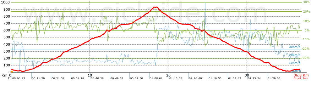
Distance in Km: 36.77
Climb in m: 1058
IBP: 73 BYC


 Height in m      Climb in %      Speed in Km/h      Speed < 2 Km/h

Climbs > 5%

Climbs >5% Climbs >10% Climbs >15% Climbs >20% Climbs >25%
 Steep slope of 134 m.   Average slope  Distances  Download as waypoint
1
 Km 1.831  6%  134 m
 Steep slope of 174 m.  Average slope  Distances  Download as waypoint
2
 Km 2.851  8%  174 m
 Steep slope of 107 m.  Average slope  Distances  Download as waypoint
3
 Km 3.134  21%  107 m
 Steep slope of 153 m.  Average slope  Distances  Download as waypoint
4
 Km 3.355  5%  31 m
5
 Km 3.386  13%  122 m
 Steep slope of 374 m.  Average slope  Distances  Download as waypoint
6
 Km 3.647  8%  66 m
7
 Km 3.713  14%  189 m
8
 Km 3.902  8%  119 m
 Steep slope of 166 m.  Average slope  Distances  Download as waypoint
9
 Km 4.625  9%  166 m
 Steep slope of 185 m.  Average slope  Distances  Download as waypoint
10
 Km 4.902  9%  185 m
 Steep slope of 394 m.  Average slope  Distances  Download as waypoint
11
 Km 5.673  7%  394 m
 Steep slope of 410 m.  Average slope  Distances  Download as waypoint
12
 Km 6.254  10%  45 m
13
 Km 6.299  14%  326 m
14
 Km 6.625  14%  39 m
 Steep slope of 181 m.  Average slope  Distances  Download as waypoint
15
 Km 7.124  9%  181 m
 Steep slope of 239 m.  Average slope  Distances  Download as waypoint
16
 Km 7.422  8%  239 m
 Steep slope of 1209 m.  Average slope  Distances  Download as waypoint
17
 Km 8.341  6%  1209 m
 Steep slope of 463 m.  Average slope  Distances  Download as waypoint
18
 Km 9.72  8%  463 m
 Steep slope of 153 m.  Average slope  Distances  Download as waypoint
19
 Km 10.491  6%  153 m
 Steep slope of 843 m.  Average slope  Distances  Download as waypoint
20
 Km 11.297  7%  484 m
21
 Km 11.781  14%  359 m
 Steep slope of 402 m.  Average slope  Distances  Download as waypoint
22
 Km 12.468  9%  402 m
 Steep slope of 448 m.  Average slope  Distances  Download as waypoint
23
 Km 13.324  9%  76 m
24
 Km 13.4  13%  153 m
25
 Km 13.553  8%  219 m
 Steep slope of 514 m.  Average slope  Distances  Download as waypoint
26
 Km 15.433  8%  514 m
 Steep slope of 1042 m.  Average slope  Distances  Download as waypoint
27
 Km 16.053  7%  845 m
28
 Km 16.897  10%  119 m
29
 Km 17.017  10%  78 m
 Steep slope of 856 m.  Average slope  Distances  Download as waypoint
30
 Km 17.317  9%  223 m
31
 Km 17.54  11%  231 m
32
 Km 17.771  11%  103 m
33
 Km 17.874  13%  257 m
34
 Km 18.131  9%  42 m
 Steep slope of 216 m.  Average slope  Distances  Download as waypoint
35
 Km 24.339  10%  168 m
36
 Km 24.507  12%  48 m
 Steep slope of 116 m.  Average slope  Distances  Download as waypoint
37
 Km 33.43  8%  116 m
 Steep slope of 182 m.  Average slope  Distances  Download as waypoint
38
 Km 35.619  6%  182 m


Description of the route


Presence of ramps


 Climbs  Distance  % of the total  Speed  Your speed would be  Time  Your time would be
   15 - 30%  0.421  1.15  13.66  ?  0:01:51  ?
   10 - 15%  2.164  5.89  15.07  ?  0:08:37  ?
   5 - 10%  6.817  18.54  15.61  ?  0:26:12  ?
   1 - 5%  7.407  20.14  17.09  ?  0:26:00  ?
   Total*  16.81 Km  45.71 %  16.09 Km/h  ? Km/h    1:02:40 h  ? h  
 Flat
   1 - -1%  2.731 Km  7.43 %  22.65 Km/h  ? Km/h    0:07:14 h  ? h  
 Descents
   -1 - -5%  7.486  20.36  30.35  ?  0:14:48  ?
   -5 - -10%  7.151  19.45  41.12  ?  0:10:26  ?
   -10 - -15%  2.233  6.07  46.19  ?  0:02:54  ?
   -15 - -30%  0.364  0.99  45.19  ?  0:00:29  ?
   Total*  17.234 Km  46.86 %  36.13 Km/h  ? Km/h    0:28:37 h  ? h  
* The total has not necessarily coincide with the sum of the partials after correction of errors

How long would it take you?

How long would it take you to cover this route?
There are routes without a valid time information, but with your average stats you can assess the possible duration

Javier_Vazquez_Fuentesal to cover this route you've need a time of:   1:38:31 h 
If you sign in and have a minimum of two tracks of this same modality, you can know your time for this route, calculated from your stats..


¿Cuanto consumirá tu E-BIKE?

Entra tu E-IBP (formato n,nn)

E-IBP :   X 73 = 


 Detected activity type =  ()
 Penalization due to track conditions: 60 %   ( > 50 % = MTB, < 50 % = RDB)
 Reliability of the track: A   (1058/82/0/-/-/82)
 Correction level applied to the track: 0
DIFFICULTY OF THE ROUTE
IBP = 73 BYC
According to your statistics
 Your time in motion would be: ? h
Your average speed would be: ? Km/h
 

 Total Distance: 36.77 Km
 Analysed distance: 36.77 Km
 Linear distance: 0.04 Km

 Cumulated positive ramps: 1057.6 m  list of points info
 Cumulated negative ramps: 1056.9 m
 Maximum height: 935.3 m
 Minimum height: 13.1 m
 Climbing Ratio: 6.29 %
 Descent ratio: 6.13 %
 Cumulated postive ramps per Km: 28.76 m
 Cumulated negative ramps per Km: 28.74 m

 Total time: 1:41:36 h
 Time in movement: 1:38:31 h
 According to your statistics
 Your time in motion would be: ? h  
 Stopped time: 0:03:05 h
 Maximum slope filter: ~30 %
 Minimum separation analysed: ~30 m
 Number of points: 1946   (cad. 18.9 m)
 Significant waypoints: 905   (cad. 40.63 m / 46.51 %)

 Changes in direction per Km: 8.92
 Changes in direction > 5º por Km: 6.74
 Cumulated straight stretches: 6.533 Km
 Straight stretches per Km: 177.67 m
 Penalized slope changes: 6
 Penalized slope changes per Km: 0.163

 Average speed in total: 21.72 Km/h
 Average speed while moving: 22.39 Km/h
 According to your statistics
 Your average speed would be: ? Km/h  
 Maximum sustained speed: 67.87 Km/h


Comments

You can be the first one in commenting this route

 
My comments
:
Add comment  (Registered users)
 
Notify me answers to my comment  Do not notify answers to my comment


Share this route with a friend

Your friend will receive a message with a link to this page:
will see your email and your user name if you do it as registered user.


Write here your name (optional)

E-mail address of your friend(s). You can include various addresses separated by commas

Text or comment (optional) maximum 255 characters long, 255 Available characters

As a non registered users you need to fill-in the captcha text.
  Change image
Type the image characters.
 
 Share with a friend


Visited history

Delete history

Marked routes for review later or compare

My favorites


  Notify anomaly in this route Share in Facebook