MTB: La Gota-Tristán-Gátova-Tristán-El Poll

MTB
MTB
Ref..: 838566
Published: 05/10/2019
Performed: 05/10/2019
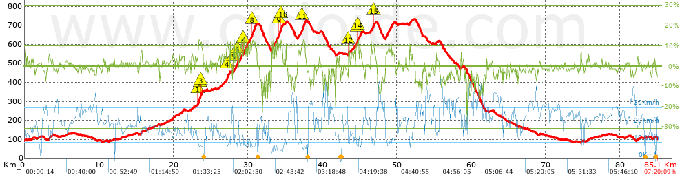
Distance in Km: 85.11
Climb in m: 1462
IBP: 108 BYC

Near ...
Aeropuerto De Manises (Valencia), Cañada, La, Collado (Partida), Presa, La, Riba-Roja De Turia, Vallesa, La (Urbanizacion)
asegovia
Author: asegovia
375 published routes

Add to my Group or Club

 Height in m      Climb in %      Speed in Km/h      Speed < 2 Km/h

Climbs > 5%

Climbs >5% Climbs >10% Climbs >15% Climbs >20% Climbs >25%
 Steep slope of 162 m.   Average slope  Distances  Download as waypoint
1
 Km 3.303  6%  162 m
 Steep slope of 157 m.  Average slope  Distances  Download as waypoint
2
 Km 15.621  7%  157 m
 Steep slope of 186 m.  Average slope  Distances  Download as waypoint
3
 Km 19.865  5%  186 m
 Steep slope of 156 m.  Average slope  Distances  Download as waypoint
4
 Km 21.134  5%  156 m
 Steep slope of 141 m.  Average slope  Distances  Download as waypoint
5
 Km 22.401  5%  141 m
 Steep slope of 752 m.  Average slope  Distances  Download as waypoint
6
 Km 23.186  6%  112 m
7
 Km 23.298  11%  236 m
8
 Km 23.534  10%  109 m
9
 Km 23.643  11%  264 m
10
 Km 23.908  10%  31 m
 Steep slope of 136 m.  Average slope  Distances  Download as waypoint
11
 Km 26.521  5%  136 m
 Steep slope of 381 m.  Average slope  Distances  Download as waypoint
12
 Km 27.107  8%  105 m
13
 Km 27.212  11%  206 m
14
 Km 27.418  12%  70 m
 Steep slope of 144 m.  Average slope  Distances  Download as waypoint
15
 Km 28.045  12%  109 m
16
 Km 28.155  9%  35 m
 Steep slope of 341 m.  Average slope  Distances  Download as waypoint
17
 Km 28.342  8%  241 m
18
 Km 28.583  14%  100 m
 Steep slope of 349 m.  Average slope  Distances  Download as waypoint
19
 Km 28.835  6%  140 m
20
 Km 28.975  8%  105 m
21
 Km 29.08  10%  104 m
 Steep slope of 378 m.  Average slope  Distances  Download as waypoint
22
 Km 29.335  5%  73 m
23
 Km 29.408  13%  131 m
24
 Km 29.539  8%  174 m
 Steep slope of 268 m.  Average slope  Distances  Download as waypoint
25
 Km 29.815  8%  268 m
 Steep slope of 969 m.  Average slope  Distances  Download as waypoint
26
 Km 30.188  8%  353 m
27
 Km 30.541  11%  371 m
28
 Km 30.913  9%  245 m
 Steep slope of 291 m.  Average slope  Distances  Download as waypoint
29
 Km 33.163  8%  291 m
 Steep slope of 1086 m.  Average slope  Distances  Download as waypoint
30
 Km 33.587  8%  561 m
31
 Km 34.149  11%  196 m
32
 Km 34.344  8%  98 m
33
 Km 34.442  12%  165 m
34
 Km 34.607  8%  66 m
 Steep slope of 236 m.  Average slope  Distances  Download as waypoint
35
 Km 36.714  6%  236 m
 Steep slope of 717 m.  Average slope  Distances  Download as waypoint
36
 Km 37.051  6%  179 m
37
 Km 37.23  11%  307 m
38
 Km 37.537  10%  231 m
 Steep slope of 174 m.  Average slope  Distances  Download as waypoint
39
 Km 43.496  11%  103 m
40
 Km 43.599  8%  71 m
 Steep slope of 112 m.  Average slope  Distances  Download as waypoint
41
 Km 43.883  6%  112 m
 Steep slope of 144 m.  Average slope  Distances  Download as waypoint
42
 Km 44.213  8%  144 m
 Steep slope of 677 m.  Average slope  Distances  Download as waypoint
43
 Km 44.535  9%  106 m
44
 Km 44.641  12%  99 m
45
 Km 44.74  12%  137 m
46
 Km 44.877  8%  335 m
 Steep slope of 620 m.  Average slope  Distances  Download as waypoint
47
 Km 46.511  8%  320 m
48
 Km 46.831  10%  97 m
49
 Km 46.928  6%  203 m
 Steep slope of 799 m.  Average slope  Distances  Download as waypoint
50
 Km 48.495  8%  799 m
 Steep slope of 180 m.  Average slope  Distances  Download as waypoint
51
 Km 49.439  6%  180 m
 Steep slope of 169 m.  Average slope  Distances  Download as waypoint
52
 Km 51.658  7%  169 m
 Steep slope of 114 m.  Average slope  Distances  Download as waypoint
53
 Km 55.265  7%  114 m


Description of the route


Presence of ramps


 Climbs  Distance  % of the total  Speed  Your speed would be  Time  Your time would be
   15 - 30%  0.135  0.16  8.84  ?  0:00:55  ?
   10 - 15%  3.494  4.11  8.8  ?  0:23:50  ?
   5 - 10%  7.576  8.9  11.43  ?  0:39:47  ?
   1 - 5%  20.735  24.36  17.73  ?  1:10:11  ?
   Total*  31.94 Km  37.53 %  14.23 Km/h  ? Km/h    2:14:43 h  ? h  
 Flat
   1 - -1%  21.651 Km  25.44 %  22.76 Km/h  ? Km/h    0:57:04 h  ? h  
 Descents
   -1 - -5%  20.609  24.21  27.85  ?  0:44:24  ?
   -5 - -10%  8.201  9.64  28.92  ?  0:17:01  ?
   -10 - -15%  2.129  2.5  22.88  ?  0:05:35  ?
   -15 - -30%  0.578  0.68  17.79  ?  0:01:57  ?
   Total*  31.517 Km  37.03 %  27.43 Km/h  ? Km/h    1:08:57 h  ? h  
* The total has not necessarily coincide with the sum of the partials after correction of errors

How long would it take you?

How long would it take you to cover this route?
There are routes without a valid time information, but with your average stats you can assess the possible duration

asegovia to cover this route you've need a time of:   4:20:44 h 
If you sign in and have a minimum of two tracks of this same modality, you can know your time for this route, calculated from your stats..


¿Cuanto consumirá tu E-BIKE?

Entra tu E-IBP (formato n,nn)

E-IBP :   X 108 = 


 Detected activity type =  ()
 Penalization due to track conditions: 54 %   ( > 50 % = MTB, < 50 % = RDB)
 Reliability of the track: A   (1462/75/0/-/-/75)
 Correction level applied to the track: 0
DIFFICULTY OF THE ROUTE
IBP = 108 BYC
According to your statistics
 Your time in motion would be: ? h
Your average speed would be: ? Km/h
 

 Total Distance: 85.11 Km
 Analysed distance: 85.11 Km
 Linear distance: 0.13 Km

 Cumulated positive ramps: 1462.4 m  list of points info
 Cumulated negative ramps: 1448.69 m
 Maximum height: 732.4 m
 Minimum height: 85.2 m
 Climbing Ratio: 4.58 %
 Descent ratio: 4.6 %
 Cumulated postive ramps per Km: 17.18 m
 Cumulated negative ramps per Km: 17.02 m

 Total time: 7:20:09 h
 Time in movement: 4:20:44 h
 According to your statistics
 Your time in motion would be: ? h  
 Stopped time: 2:59:25 h
 Maximum slope filter: ~30 %
 Minimum separation analysed: ~30 m
 Number of points: 6435   (cad. 13.23 m)
 Significant waypoints: 2380   (cad. 35.76 m / 36.99 %)

 Changes in direction per Km: 11.12
 Changes in direction > 5º por Km: 7.54
 Cumulated straight stretches: 20.48 Km
 Straight stretches per Km: 240.63 m
 Penalized slope changes: 16
 Penalized slope changes per Km: 0.188

 Average speed in total: 11.6 Km/h
 Average speed while moving: 19.59 Km/h
 According to your statistics
 Your average speed would be: ? Km/h  
 Maximum sustained speed: 48.84 Km/h


Comments

You can be the first one in commenting this route

 
My comments
:
Add comment  (Registered users)
 
Notify me answers to my comment  Do not notify answers to my comment


Share this route with a friend

Your friend will receive a message with a link to this page:
will see your email and your user name if you do it as registered user.


Write here your name (optional)

E-mail address of your friend(s). You can include various addresses separated by commas

Text or comment (optional) maximum 255 characters long, 255 Available characters

As a non registered users you need to fill-in the captcha text.
  Change image
Type the image characters.
 
 Share with a friend


Visited history

Delete history

Marked routes for review later or compare

My favorites


  Notify anomaly in this route Share in Facebook