UNA VUELTECITA POR VALLRROMANES TrackTrackTrack

MTB
MTB
Ref..: 836321
Published: 01/10/2019
Performed: 01/10/2019
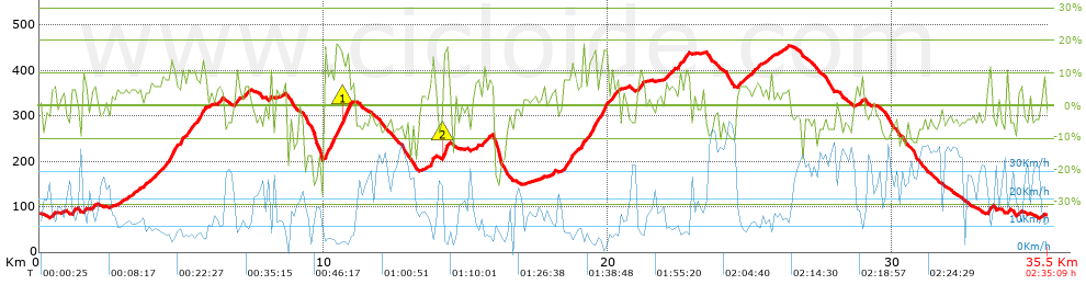
Distance in Km: 35.47
Climb in m: 1091
IBP: 86 BYC

CARLOS_ALDEA_TUDELA
531 published routes

Add to my Group or Club

 Height in m      Climb in %      Speed in Km/h      Speed < 2 Km/h

Climbs > 5%

Climbs >5% Climbs >10% Climbs >15% Climbs >20% Climbs >25%
 Steep slope of 166 m.   Average slope  Distances  Download as waypoint
1
 Km 0.376  5%  166 m
 Steep slope of 115 m.  Average slope  Distances  Download as waypoint
2
 Km 1.135  8%  115 m
 Steep slope of 156 m.  Average slope  Distances  Download as waypoint
3
 Km 1.534  7%  156 m
 Steep slope of 116 m.  Average slope  Distances  Download as waypoint
4
 Km 1.866  7%  116 m
 Steep slope of 159 m.  Average slope  Distances  Download as waypoint
5
 Km 3.297  5%  159 m
 Steep slope of 1409 m.  Average slope  Distances  Download as waypoint
6
 Km 3.885  7%  681 m
7
 Km 4.567  13%  168 m
8
 Km 4.735  7%  238 m
9
 Km 4.972  11%  115 m
10
 Km 5.087  8%  207 m
 Steep slope of 424 m.  Average slope  Distances  Download as waypoint
11
 Km 5.405  8%  191 m
12
 Km 5.596  12%  167 m
13
 Km 5.763  7%  66 m
 Steep slope of 163 m.  Average slope  Distances  Download as waypoint
14
 Km 6.281  7%  163 m
 Steep slope of 154 m.  Average slope  Distances  Download as waypoint
15
 Km 6.855  7%  154 m
 Steep slope of 218 m.  Average slope  Distances  Download as waypoint
16
 Km 7.215  7%  218 m
 Steep slope of 95 m.  Average slope  Distances  Download as waypoint
17
 Km 8.093  9%  95 m
 Steep slope of 991 m.  Average slope  Distances  Download as waypoint
18
 Km 10.034  14%  346 m
19
 Km 10.38  12%  146 m
20
 Km 10.527  12%  102 m
21
 Km 10.629  15%  150 m
22
 Km 10.779  17%  78 m
23
 Km 10.857  8%  169 m
 Steep slope of 168 m.  Average slope  Distances  Download as waypoint
24
 Km 13.735  6%  38 m
25
 Km 13.773  17%  99 m
26
 Km 13.872  7%  31 m
 Steep slope of 246 m.  Average slope  Distances  Download as waypoint
27
 Km 14.188  17%  148 m
28
 Km 14.336  14%  69 m
29
 Km 14.405  6%  29 m
 Steep slope of 121 m.  Average slope  Distances  Download as waypoint
30
 Km 15.339  8%  121 m
 Steep slope of 328 m.  Average slope  Distances  Download as waypoint
31
 Km 15.584  7%  328 m
 Steep slope of 515 m.  Average slope  Distances  Download as waypoint
32
 Km 18.307  6%  373 m
33
 Km 18.68  12%  107 m
34
 Km 18.788  9%  35 m
 Steep slope of 1008 m.  Average slope  Distances  Download as waypoint
35
 Km 18.933  7%  413 m
36
 Km 19.345  12%  262 m
37
 Km 19.608  8%  113 m
38
 Km 19.72  8%  107 m
39
 Km 19.827  14%  113 m
 Steep slope of 302 m.  Average slope  Distances  Download as waypoint
40
 Km 20.123  9%  302 m
 Steep slope of 199 m.  Average slope  Distances  Download as waypoint
41
 Km 21.041  8%  199 m
 Steep slope of 313 m.  Average slope  Distances  Download as waypoint
42
 Km 22.001  6%  313 m
 Steep slope of 381 m.  Average slope  Distances  Download as waypoint
43
 Km 22.451  8%  381 m
 Steep slope of 318 m.  Average slope  Distances  Download as waypoint
44
 Km 24.552  6%  318 m
 Steep slope of 352 m.  Average slope  Distances  Download as waypoint
45
 Km 24.988  6%  352 m
 Steep slope of 117 m.  Average slope  Distances  Download as waypoint
46
 Km 25.686  8%  117 m
 Steep slope of 188 m.  Average slope  Distances  Download as waypoint
47
 Km 33.343  5%  39 m
48
 Km 33.382  12%  116 m
49
 Km 33.498  10%  33 m
 Steep slope of 111 m.  Average slope  Distances  Download as waypoint
50
 Km 34.032  11%  111 m
 Steep slope of 125 m.  Average slope  Distances  Download as waypoint
51
 Km 34.417  5%  125 m


Description of the route


Presence of ramps


 Climbs  Distance  % of the total  Speed  Your speed would be  Time  Your time would be
   15 - 30%  0.759  2.14  4.97  ?  0:09:10  ?
   10 - 15%  2.035  5.74  7.08  ?  0:17:14  ?
   5 - 10%  6.965  19.64  9.7  ?  0:43:04  ?
   1 - 5%  7.436  20.96  13.49  ?  0:33:04  ?
   Total*  17.195 Km  48.47 %  10.06 Km/h  ? Km/h    1:42:32 h  ? h  
 Flat
   1 - -1%  1.857 Km  5.23 %  18.07 Km/h  ? Km/h    0:06:10 h  ? h  
 Descents
   -1 - -5%  7.134  20.11  24.89  ?  0:17:12  ?
   -5 - -10%  6.618  18.66  28.26  ?  0:14:03  ?
   -10 - -15%  1.637  4.61  18.7  ?  0:05:15  ?
   -15 - -30%  1.032  2.91  8.02  ?  0:07:43  ?
   Total*  16.421 Km  46.29 %  22.28 Km/h  ? Km/h    0:44:13 h  ? h  
* The total has not necessarily coincide with the sum of the partials after correction of errors

How long would it take you?

How long would it take you to cover this route?
There are routes without a valid time information, but with your average stats you can assess the possible duration

CARLOS_ALDEA_TUDELA to cover this route you've need a time of:   2:32:55 h 
If you sign in and have a minimum of two tracks of this same modality, you can know your time for this route, calculated from your stats..


¿Cuanto consumirá tu E-BIKE?

Entra tu E-IBP (formato n,nn)

E-IBP :   X 86 = 


 Detected activity type =  ()
 Penalization due to track conditions: 75 %   ( > 50 % = MTB, < 50 % = RDB)
 Reliability of the track: B   (1091/69/0/-/-/69)
 Correction level applied to the track: 0
DIFFICULTY OF THE ROUTE
IBP = 86 BYC
According to your statistics
 Your time in motion would be: ? h
Your average speed would be: ? Km/h
 

 Total Distance: 35.47 Km
 Analysed distance: 35.47 Km
 Linear distance: 0.02 Km

 Cumulated positive ramps: 1091.4 m  list of points info
 Cumulated negative ramps: 1094.4 m
 Maximum height: 454.8 m
 Minimum height: 74.8 m
 Climbing Ratio: 6.35 %
 Descent ratio: 6.66 %
 Cumulated postive ramps per Km: 30.77 m
 Cumulated negative ramps per Km: 30.85 m

 Total time: 2:35:09 h
 Time in movement: 2:32:55 h
 According to your statistics
 Your time in motion would be: ? h  
 Stopped time: 0:02:14 h
 Maximum slope filter: ~30 %
 Minimum separation analysed: ~30 m
 Number of points: 2037   (cad. 17.41 m)
 Significant waypoints: 918   (cad. 38.64 m / 45.07 %)

 Changes in direction per Km: 10.26
 Changes in direction > 5º por Km: 7.72
 Cumulated straight stretches: 6.473 Km
 Straight stretches per Km: 182.49 m
 Penalized slope changes: 13
 Penalized slope changes per Km: 0.366

 Average speed in total: 13.72 Km/h
 Average speed while moving: 13.92 Km/h
 According to your statistics
 Your average speed would be: ? Km/h  
 Maximum sustained speed: 51.76 Km/h


Comments

You can be the first one in commenting this route

 
My comments
:
Add comment  (Registered users)
 
Notify me answers to my comment  Do not notify answers to my comment


Share this route with a friend

Your friend will receive a message with a link to this page:
will see your email and your user name if you do it as registered user.


Write here your name (optional)

E-mail address of your friend(s). You can include various addresses separated by commas

Text or comment (optional) maximum 255 characters long, 255 Available characters

As a non registered users you need to fill-in the captcha text.
  Change image
Type the image characters.
 
 Share with a friend


Visited history

Delete history

Marked routes for review later or compare

My favorites


  Notify anomaly in this route Share in Facebook