Aprovechando los últimos días de__entre semana.

MTB
MTB
Ref..: 827810
Published: 20/09/2019
Performed: 17/09/2019
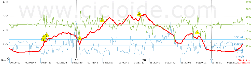
Distance in Km: 34.66
Climb in m: 656
IBP: 49 BYC

Near ...
Castellbisbal, Fontpineda Urbanizacion (Palleja) (Urbanitzacio), Palleja, Sant Andreu De La Barca
Cristóbal
Author: Cristóbal
177 published routes

Add to my Group or Club

 Height in m      Climb in %      Speed in Km/h      Speed < 2 Km/h

Climbs > 5%

Climbs >5% Climbs >10% Climbs >15% Climbs >20% Climbs >25%
 Steep slope of 710 m.   Average slope  Distances  Download as waypoint
1
 Km 4.53  7%  428 m
2
 Km 4.958  9%  127 m
3
 Km 5.085  17%  39 m
4
 Km 5.124  19%  67 m
5
 Km 5.191  7%  49 m
 Steep slope of 152 m.  Average slope  Distances  Download as waypoint
6
 Km 5.492  6%  36 m
7
 Km 5.529  13%  116 m
 Steep slope of 125 m.  Average slope  Distances  Download as waypoint
8
 Km 6.439  9%  125 m
 Steep slope of 219 m.  Average slope  Distances  Download as waypoint
9
 Km 7.02  6%  219 m
 Steep slope of 107 m.  Average slope  Distances  Download as waypoint
10
 Km 7.817  9%  107 m
 Steep slope of 323 m.  Average slope  Distances  Download as waypoint
11
 Km 10.46  14%  183 m
12
 Km 10.643  8%  140 m
 Steep slope of 193 m.  Average slope  Distances  Download as waypoint
13
 Km 11.434  9%  193 m
 Steep slope of 195 m.  Average slope  Distances  Download as waypoint
14
 Km 11.756  8%  195 m
 Steep slope of 109 m.  Average slope  Distances  Download as waypoint
15
 Km 12.654  7%  109 m
 Steep slope of 599 m.  Average slope  Distances  Download as waypoint
16
 Km 13.338  6%  470 m
17
 Km 13.808  12%  129 m
 Steep slope of 367 m.  Average slope  Distances  Download as waypoint
18
 Km 14.417  6%  367 m
 Steep slope of 199 m.  Average slope  Distances  Download as waypoint
19
 Km 16.13  5%  199 m
 Steep slope of 914 m.  Average slope  Distances  Download as waypoint
20
 Km 16.83  6%  914 m
 Steep slope of 384 m.  Average slope  Distances  Download as waypoint
21
 Km 19.231  9%  72 m
22
 Km 19.303  11%  101 m
23
 Km 19.404  8%  211 m
 Steep slope of 100 m.  Average slope  Distances  Download as waypoint
24
 Km 19.84  11%  100 m
 Steep slope of 588 m.  Average slope  Distances  Download as waypoint
25
 Km 25.526  8%  588 m
 Steep slope of 106 m.  Average slope  Distances  Download as waypoint
26
 Km 27.889  13%  106 m
 Steep slope of 185 m.  Average slope  Distances  Download as waypoint
27
 Km 33.792  5%  185 m


Description of the route


Presence of ramps


 Climbs  Distance  % of the total  Speed  Your speed would be  Time  Your time would be
   15 - 30%  0.295  0.85  7.13  ?  0:02:29  ?
   10 - 15%  0.849  2.45  7.98  ?  0:06:23  ?
   5 - 10%  5.21  15.03  10.55  ?  0:29:38  ?
   1 - 5%  4.669  13.47  13.98  ?  0:20:02  ?
   Total*  11.023 Km  31.81 %  11.3 Km/h  ? Km/h    0:58:32 h  ? h  
 Flat
   1 - -1%  11.301 Km  32.61 %  21.58 Km/h  ? Km/h    0:31:25 h  ? h  
 Descents
   -1 - -5%  7.82  22.56  23.6  ?  0:19:53  ?
   -5 - -10%  3.213  9.27  25.64  ?  0:07:31  ?
   -10 - -15%  0.899  2.59  20.47  ?  0:02:38  ?
   -15 - -30%  0.401  1.16  19.52  ?  0:01:14  ?
   Total*  12.333 Km  35.59 %  23.67 Km/h  ? Km/h    0:31:16 h  ? h  
* The total has not necessarily coincide with the sum of the partials after correction of errors

How long would it take you?

How long would it take you to cover this route?
There are routes without a valid time information, but with your average stats you can assess the possible duration

Cristóbal to cover this route you've need a time of:   2:01:13 h 
If you sign in and have a minimum of two tracks of this same modality, you can know your time for this route, calculated from your stats..


¿Cuanto consumirá tu E-BIKE?

Entra tu E-IBP (formato n,nn)

E-IBP :   X 49 = 


 Detected activity type =  ()
 Penalization due to track conditions: 64 %   ( > 50 % = MTB, < 50 % = RDB)
 Reliability of the track: B   (656/71/0/-/-/71)
 Correction level applied to the track: 0
DIFFICULTY OF THE ROUTE
IBP = 49 BYC
According to your statistics
 Your time in motion would be: ? h
Your average speed would be: ? Km/h
 

 Total Distance: 34.66 Km
 Analysed distance: 34.66 Km
 Linear distance: 0.2 Km

 Cumulated positive ramps: 656.4 m  list of points info
 Cumulated negative ramps: 613.2 m
 Maximum height: 314.8 m
 Minimum height: 39.8 m
 Climbing Ratio: 5.95 %
 Descent ratio: 4.97 %
 Cumulated postive ramps per Km: 18.94 m
 Cumulated negative ramps per Km: 17.69 m

 Total time: 2:01:13 h
 Time in movement: 2:01:13 h
 According to your statistics
 Your time in motion would be: ? h  
 Stopped time: 0:00:00 h
 Maximum slope filter: ~30 %
 Minimum separation analysed: ~30 m
 Number of points: 1642   (cad. 21.11 m)
 Significant waypoints: 836   (cad. 41.46 m / 50.91 %)

 Changes in direction per Km: 9.98
 Changes in direction > 5º por Km: 7.1
 Cumulated straight stretches: 6.7 Km
 Straight stretches per Km: 193.31 m
 Penalized slope changes: 9
 Penalized slope changes per Km: 0.26

 Average speed in total: 17.15 Km/h
 Average speed while moving: 17.16 Km/h
 According to your statistics
 Your average speed would be: ? Km/h  
 Maximum sustained speed: 61.22 Km/h


Comments

You can be the first one in commenting this route

 
My comments
:
Add comment  (Registered users)
 
Notify me answers to my comment  Do not notify answers to my comment


Share this route with a friend

Your friend will receive a message with a link to this page:
will see your email and your user name if you do it as registered user.


Write here your name (optional)

E-mail address of your friend(s). You can include various addresses separated by commas

Text or comment (optional) maximum 255 characters long, 255 Available characters

As a non registered users you need to fill-in the captcha text.
  Change image
Type the image characters.
 
 Share with a friend


Visited history

Delete history

Marked routes for review later or compare

My favorites


  Notify anomaly in this route Share in Facebook