Rincon De La Victoria (Málaga)

MTB
MTB
Ref..: 825693
Published: 16/09/2019
Performed: 15/09/2019
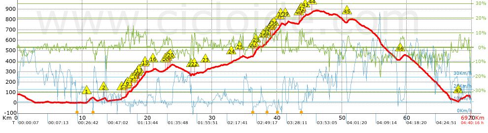
Distance in Km: 69.88
Climb in m: 1344
IBP: 88 BYC


 Height in m      Climb in %      Speed in Km/h      Speed < 2 Km/h

Climbs > 5%

Climbs >5% Climbs >10% Climbs >15% Climbs >20% Climbs >25%
 Steep slope of 573 m.   Average slope  Distances  Download as waypoint
1
 Km 10.672  6%  573 m
 Steep slope of 114 m.  Average slope  Distances  Download as waypoint
2
 Km 13.309  6%  114 m
 Steep slope of 117 m.  Average slope  Distances  Download as waypoint
3
 Km 16.037  7%  117 m
 Steep slope of 423 m.  Average slope  Distances  Download as waypoint
4
 Km 16.654  5%  86 m
5
 Km 16.74  11%  259 m
6
 Km 16.999  14%  78 m
 Steep slope of 405 m.  Average slope  Distances  Download as waypoint
7
 Km 17.513  6%  44 m
8
 Km 17.557  11%  106 m
9
 Km 17.663  9%  255 m
 Steep slope of 570 m.  Average slope  Distances  Download as waypoint
10
 Km 18.086  7%  371 m
11
 Km 18.457  11%  119 m
12
 Km 18.576  10%  80 m
 Steep slope of 1048 m.  Average slope  Distances  Download as waypoint
13
 Km 18.768  8%  742 m
14
 Km 19.51  10%  160 m
15
 Km 19.67  10%  146 m
 Steep slope of 118 m.  Average slope  Distances  Download as waypoint
16
 Km 20.875  6%  118 m
 Steep slope of 146 m.  Average slope  Distances  Download as waypoint
17
 Km 22.776  6%  146 m
 Steep slope of 111 m.  Average slope  Distances  Download as waypoint
18
 Km 23.014  10%  111 m
 Steep slope of 140 m.  Average slope  Distances  Download as waypoint
19
 Km 23.337  6%  140 m
 Steep slope of 126 m.  Average slope  Distances  Download as waypoint
20
 Km 23.602  7%  126 m
 Steep slope of 187 m.  Average slope  Distances  Download as waypoint
21
 Km 26.799  7%  187 m
 Steep slope of 149 m.  Average slope  Distances  Download as waypoint
22
 Km 27.228  8%  149 m
 Steep slope of 227 m.  Average slope  Distances  Download as waypoint
23
 Km 28.99  6%  227 m
 Steep slope of 196 m.  Average slope  Distances  Download as waypoint
24
 Km 32.987  5%  196 m
 Steep slope of 112 m.  Average slope  Distances  Download as waypoint
25
 Km 34.222  5%  112 m
 Steep slope of 989 m.  Average slope  Distances  Download as waypoint
26
 Km 36.266  9%  227 m
27
 Km 36.493  12%  284 m
28
 Km 36.778  7%  478 m
 Steep slope of 180 m.  Average slope  Distances  Download as waypoint
29
 Km 37.844  8%  180 m
 Steep slope of 579 m.  Average slope  Distances  Download as waypoint
30
 Km 38.254  8%  45 m
31
 Km 38.3  10%  101 m
32
 Km 38.4  7%  433 m
 Steep slope of 501 m.  Average slope  Distances  Download as waypoint
33
 Km 38.937  7%  153 m
34
 Km 39.09  10%  181 m
35
 Km 39.271  7%  167 m
 Steep slope of 1121 m.  Average slope  Distances  Download as waypoint
36
 Km 39.556  7%  779 m
37
 Km 40.335  12%  215 m
38
 Km 40.55  9%  127 m
 Steep slope of 367 m.  Average slope  Distances  Download as waypoint
39
 Km 41.289  8%  367 m
 Steep slope of 321 m.  Average slope  Distances  Download as waypoint
40
 Km 43.371  10%  175 m
41
 Km 43.546  9%  146 m
 Steep slope of 389 m.  Average slope  Distances  Download as waypoint
42
 Km 43.806  8%  389 m
 Steep slope of 119 m.  Average slope  Distances  Download as waypoint
43
 Km 44.398  6%  119 m
 Steep slope of 133 m.  Average slope  Distances  Download as waypoint
44
 Km 45.359  6%  133 m
 Steep slope of 320 m.  Average slope  Distances  Download as waypoint
45
 Km 50.764  7%  320 m
 Steep slope of 452 m.  Average slope  Distances  Download as waypoint
46
 Km 58.96  7%  452 m
 Steep slope of 349 m.  Average slope  Distances  Download as waypoint
47
 Km 67.98  8%  349 m


Description of the route


Presence of ramps


 Climbs  Distance  % of the total  Speed  Your speed would be  Time  Your time would be
   15 - 30%  0.033  0.05  7.94  ?  0:00:15  ?
   10 - 15%  2.333  3.34  6.63  ?  0:21:06  ?
   5 - 10%  9.076  12.99  9.89  ?  0:55:05  ?
   1 - 5%  15.226  21.79  14.11  ?  1:04:44  ?
   Total*  26.668 Km  38.16 %  11.33 Km/h  ? Km/h    2:21:10 h  ? h  
 Flat
   1 - -1%  13.114 Km  18.77 %  19.95 Km/h  ? Km/h    0:39:26 h  ? h  
 Descents
   -1 - -5%  19.24  27.53  30.84  ?  0:37:26  ?
   -5 - -10%  9.392  13.44  41.18  ?  0:13:41  ?
   -10 - -15%  1.05  1.5  37.05  ?  0:01:42  ?
   -15 - -30%  0.413  0.59  11.71  ?  0:02:07  ?
   Total*  30.094 Km  43.07 %  32.87 Km/h  ? Km/h    0:54:56 h  ? h  
* The total has not necessarily coincide with the sum of the partials after correction of errors

How long would it take you?

How long would it take you to cover this route?
There are routes without a valid time information, but with your average stats you can assess the possible duration

Javier_García-Puretas-Malaga to cover this route you've need a time of:   3:55:32 h 
If you sign in and have a minimum of two tracks of this same modality, you can know your time for this route, calculated from your stats..


¿Cuanto consumirá tu E-BIKE?

Entra tu E-IBP (formato n,nn)

E-IBP :   X 88 = 


 Detected activity type =  ()
 Penalization due to track conditions: 55 %   ( > 50 % = MTB, < 50 % = RDB)
 Reliability of the track: A   (1344/73/0/-/-/73)
 Correction level applied to the track: 0
DIFFICULTY OF THE ROUTE
IBP = 88 BYC
According to your statistics
 Your time in motion would be: ? h
Your average speed would be: ? Km/h
 

 Total Distance: 69.88 Km
 Analysed distance: 69.88 Km
 Linear distance: 0.3 Km

 Cumulated positive ramps: 1343.88 m  list of points info
 Cumulated negative ramps: 1383.08 m
 Maximum height: 885.4 m
 Minimum height: -0.6 m
 Climbing Ratio: 5.04 %
 Descent ratio: 4.6 %
 Cumulated postive ramps per Km: 19.23 m
 Cumulated negative ramps per Km: 19.79 m

 Total time: 4:40:16 h
 Time in movement: 3:55:32 h
 According to your statistics
 Your time in motion would be: ? h  
 Stopped time: 0:44:44 h
 Maximum slope filter: ~30 %
 Minimum separation analysed: ~30 m
 Number of points: 3616   (cad. 19.32 m)
 Significant waypoints: 1731   (cad. 40.37 m / 47.87 %)

 Changes in direction per Km: 10.42
 Changes in direction > 5º por Km: 8.41
 Cumulated straight stretches: 9.704 Km
 Straight stretches per Km: 138.87 m
 Penalized slope changes: 13
 Penalized slope changes per Km: 0.186

 Average speed in total: 14.96 Km/h
 Average speed while moving: 17.8 Km/h
 According to your statistics
 Your average speed would be: ? Km/h  
 Maximum sustained speed: 80.3 Km/h


Comments

You can be the first one in commenting this route

 
My comments
:
Add comment  (Registered users)
 
Notify me answers to my comment  Do not notify answers to my comment


Share this route with a friend

Your friend will receive a message with a link to this page:
will see your email and your user name if you do it as registered user.


Write here your name (optional)

E-mail address of your friend(s). You can include various addresses separated by commas

Text or comment (optional) maximum 255 characters long, 255 Available characters

As a non registered users you need to fill-in the captcha text.
  Change image
Type the image characters.
 
 Share with a friend


Visited history

Delete history

Marked routes for review later or compare

My favorites


  Notify anomaly in this route Share in Facebook