Manresa, salo, cardona, serrateix, viver navas

Road
Road
Ref..: 824689
Published: 15/09/2019
Performed: 15/09/2019
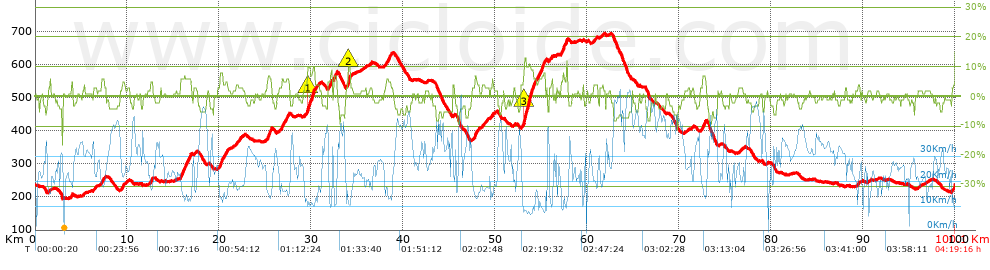
Distance in Km: 100.14
Climb in m: 1353
IBP: 92 BYC

Adam_Orozco_Vall
678 published routes

Add to my Group or Club

 Height in m      Climb in %      Speed in Km/h      Speed < 2 Km/h

Climbs > 5%

Climbs >5% Climbs >10% Climbs >15% Climbs >20% Climbs >25%
 Steep slope of 220 m.   Average slope  Distances  Download as waypoint
1
 Km 7.231  6%  220 m
 Steep slope of 211 m.  Average slope  Distances  Download as waypoint
2
 Km 9.492  5%  211 m
 Steep slope of 246 m.  Average slope  Distances  Download as waypoint
3
 Km 12.531  5%  246 m
 Steep slope of 1077 m.  Average slope  Distances  Download as waypoint
4
 Km 15.809  6%  1077 m
 Steep slope of 306 m.  Average slope  Distances  Download as waypoint
5
 Km 20.114  8%  306 m
 Steep slope of 244 m.  Average slope  Distances  Download as waypoint
6
 Km 20.699  5%  244 m
 Steep slope of 495 m.  Average slope  Distances  Download as waypoint
7
 Km 25.251  7%  495 m
 Steep slope of 277 m.  Average slope  Distances  Download as waypoint
8
 Km 26.797  6%  277 m
 Steep slope of 262 m.  Average slope  Distances  Download as waypoint
9
 Km 27.305  6%  262 m
 Steep slope of 781 m.  Average slope  Distances  Download as waypoint
10
 Km 29.593  6%  39 m
11
 Km 29.633  10%  223 m
12
 Km 29.856  8%  519 m
 Steep slope of 137 m.  Average slope  Distances  Download as waypoint
13
 Km 32.135  9%  137 m
 Steep slope of 378 m.  Average slope  Distances  Download as waypoint
14
 Km 32.466  7%  378 m
 Steep slope of 306 m.  Average slope  Distances  Download as waypoint
15
 Km 34.002  5%  43 m
16
 Km 34.045  10%  233 m
17
 Km 34.278  6%  30 m
 Steep slope of 482 m.  Average slope  Distances  Download as waypoint
18
 Km 38.191  5%  482 m
 Steep slope of 268 m.  Average slope  Distances  Download as waypoint
19
 Km 47.788  7%  268 m
 Steep slope of 1392 m.  Average slope  Distances  Download as waypoint
20
 Km 53.115  8%  41 m
21
 Km 53.156  11%  752 m
22
 Km 53.908  8%  599 m
 Steep slope of 711 m.  Average slope  Distances  Download as waypoint
23
 Km 54.782  7%  711 m
 Steep slope of 112 m.  Average slope  Distances  Download as waypoint
24
 Km 56.182  6%  112 m
 Steep slope of 674 m.  Average slope  Distances  Download as waypoint
25
 Km 57.192  7%  674 m
 Steep slope of 278 m.  Average slope  Distances  Download as waypoint
26
 Km 72.634  7%  278 m


Description of the route


Presence of ramps


 Climbs  Distance  % of the total  Speed  Your speed would be  Time  Your time would be
   15 - 30%  0  0  0  ?  0:00:00  ?
   10 - 15%  1.35  1.35  10.13  ?  0:08:00  ?
   5 - 10%  7.645  7.63  13.71  ?  0:33:28  ?
   1 - 5%  27.878  27.84  20.09  ?  1:23:16  ?
   Total*  36.873 Km  36.82 %  17.74 Km/h  ? Km/h    2:04:44 h  ? h  
 Flat
   1 - -1%  24.128 Km  24.09 %  26.61 Km/h  ? Km/h    0:54:24 h  ? h  
 Descents
   -1 - -5%  30.948  30.9  32.95  ?  0:56:21  ?
   -5 - -10%  8.049  8.04  43.64  ?  0:11:04  ?
   -10 - -15%  0.11  0.11  32.87  ?  0:00:12  ?
   -15 - -30%  0.035  0.03  31.24  ?  0:00:04  ?
   Total*  39.142 Km  39.09 %  34.7 Km/h  ? Km/h    1:07:41 h  ? h  
* The total has not necessarily coincide with the sum of the partials after correction of errors

How long would it take you?

How long would it take you to cover this route?
There are routes without a valid time information, but with your average stats you can assess the possible duration

Adam_Orozco_Vall to cover this route you've need a time of:   4:06:49 h 
If you sign in and have a minimum of two tracks of this same modality, you can know your time for this route, calculated from your stats..


¿Cuanto consumirá tu E-BIKE?

Entra tu E-IBP (formato n,nn)

E-IBP :   X 92 = 


 Detected activity type =  ()
 Penalization due to track conditions: 35 %   ( > 50 % = MTB, < 50 % = RDB)
 Reliability of the track: D   (1647/43/1/3/-/70)
 Correction level applied to the track: 4        See analyis without corrections
DIFFICULTY OF THE ROUTE
IBP = 92 BYC
According to your statistics
 Your time in motion would be: ? h
Your average speed would be: ? Km/h
 

 Total Distance: 100.14 Km
 Analysed distance: 100.14 Km
 Linear distance: 0.01 Km

 Cumulated positive ramps: 1353.4 m  list of points info
 Cumulated negative ramps: 1361.77 m
 Maximum height: 694.71 m
 Minimum height: 195.05 m
 Climbing Ratio: 3.67 %
 Descent ratio: 3.48 %
 Cumulated postive ramps per Km: 13.52 m
 Cumulated negative ramps per Km: 13.6 m

 Total time: 4:19:16 h
 Time in movement: 4:06:49 h
 According to your statistics
 Your time in motion would be: ? h  
 Stopped time: 0:12:27 h
 Maximum slope filter: ~30 %
 Minimum separation analysed: ~30 m
 Number of points: 3629   (cad. 27.6 m)
 Significant waypoints: 2448   (cad. 40.91 m / 67.46 %)

 Changes in direction per Km: 8.02
 Changes in direction > 5º por Km: 4.4
 Cumulated straight stretches: 36.657 Km
 Straight stretches per Km: 366.06 m
 Penalized slope changes: 11
 Penalized slope changes per Km: 0.11

 Average speed in total: 23.18 Km/h
 Average speed while moving: 24.34 Km/h
 According to your statistics
 Your average speed would be: ? Km/h  
 Maximum sustained speed: 58.58 Km/h


Comments

You can be the first one in commenting this route

 
My comments
:
Add comment  (Registered users)
 
Notify me answers to my comment  Do not notify answers to my comment


Share this route with a friend

Your friend will receive a message with a link to this page:
will see your email and your user name if you do it as registered user.


Write here your name (optional)

E-mail address of your friend(s). You can include various addresses separated by commas

Text or comment (optional) maximum 255 characters long, 255 Available characters

As a non registered users you need to fill-in the captcha text.
  Change image
Type the image characters.
 
 Share with a friend


Visited history

Delete history

Marked routes for review later or compare

My favorites


  Notify anomaly in this route Share in Facebook