Creixell (Tarragona)

MTB
MTB
Ref..: 822676
Published: 12/09/2019
Performed: 09/09/2019
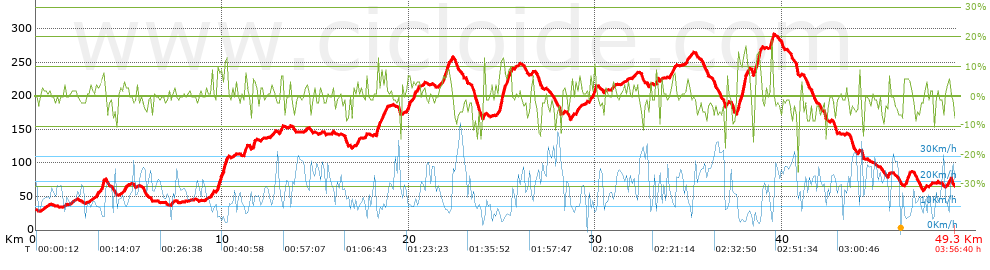
Distance in Km: 49.26
Climb in m: 857
IBP: 64 BYC


 Height in m      Climb in %      Speed in Km/h      Speed < 2 Km/h

Climbs > 5%

Climbs >5% Climbs >10% Climbs >15% Climbs >20% Climbs >25%
 Steep slope of 149 m.   Average slope  Distances  Download as waypoint
1
 Km 3.524  9%  149 m
 Steep slope of 555 m.  Average slope  Distances  Download as waypoint
2
 Km 9.731  10%  34 m
3
 Km 9.765  10%  100 m
4
 Km 9.865  7%  238 m
5
 Km 10.102  11%  116 m
6
 Km 10.219  10%  67 m
 Steep slope of 151 m.  Average slope  Distances  Download as waypoint
7
 Km 11.152  8%  151 m
 Steep slope of 129 m.  Average slope  Distances  Download as waypoint
8
 Km 11.619  8%  129 m
 Steep slope of 103 m.  Average slope  Distances  Download as waypoint
9
 Km 13.129  6%  103 m
 Steep slope of 317 m.  Average slope  Distances  Download as waypoint
10
 Km 18.266  8%  317 m
 Steep slope of 109 m.  Average slope  Distances  Download as waypoint
11
 Km 18.691  9%  109 m
 Steep slope of 147 m.  Average slope  Distances  Download as waypoint
12
 Km 19.935  8%  147 m
 Steep slope of 107 m.  Average slope  Distances  Download as waypoint
13
 Km 20.47  6%  107 m
 Steep slope of 552 m.  Average slope  Distances  Download as waypoint
14
 Km 21.791  7%  552 m
 Steep slope of 697 m.  Average slope  Distances  Download as waypoint
15
 Km 24.826  7%  39 m
16
 Km 24.865  12%  283 m
17
 Km 25.148  8%  375 m
 Steep slope of 108 m.  Average slope  Distances  Download as waypoint
18
 Km 28.681  6%  108 m
 Steep slope of 161 m.  Average slope  Distances  Download as waypoint
19
 Km 28.929  5%  161 m
 Steep slope of 208 m.  Average slope  Distances  Download as waypoint
20
 Km 29.746  7%  208 m
 Steep slope of 103 m.  Average slope  Distances  Download as waypoint
21
 Km 33.23  9%  103 m
 Steep slope of 162 m.  Average slope  Distances  Download as waypoint
22
 Km 34.11  6%  162 m
 Steep slope of 148 m.  Average slope  Distances  Download as waypoint
23
 Km 34.91  5%  148 m
 Steep slope of 617 m.  Average slope  Distances  Download as waypoint
24
 Km 37.599  12%  137 m
25
 Km 37.736  8%  90 m
26
 Km 37.826  13%  209 m
27
 Km 38.035  8%  181 m
 Steep slope of 355 m.  Average slope  Distances  Download as waypoint
28
 Km 38.503  10%  229 m
29
 Km 38.732  11%  126 m
 Steep slope of 145 m.  Average slope  Distances  Download as waypoint
30
 Km 39.393  13%  145 m
 Steep slope of 286 m.  Average slope  Distances  Download as waypoint
31
 Km 46.539  7%  286 m
 Steep slope of 143 m.  Average slope  Distances  Download as waypoint
32
 Km 48.881  6%  143 m


Description of the route


Presence of ramps


 Climbs  Distance  % of the total  Speed  Your speed would be  Time  Your time would be
   15 - 30%  0.189  0.38  5.2  ?  0:02:11  ?
   10 - 15%  1.338  2.72  6.19  ?  0:12:58  ?
   5 - 10%  5.241  10.64  9.06  ?  0:34:43  ?
   1 - 5%  11.439  23.22  13.15  ?  0:52:11  ?
   Total*  18.207 Km  36.96 %  10.7 Km/h  ? Km/h    1:42:03 h  ? h  
 Flat
   1 - -1%  12.691 Km  25.76 %  17.4 Km/h  ? Km/h    0:43:45 h  ? h  
 Descents
   -1 - -5%  11.792  23.94  18.33  ?  0:38:36  ?
   -5 - -10%  5.419  11  18.8  ?  0:17:18  ?
   -10 - -15%  0.934  1.9  13.45  ?  0:04:10  ?
   -15 - -30%  0.214  0.43  13.04  ?  0:00:59  ?
   Total*  18.359 Km  37.27 %  18.04 Km/h  ? Km/h    1:01:03 h  ? h  
* The total has not necessarily coincide with the sum of the partials after correction of errors

How long would it take you?

How long would it take you to cover this route?
There are routes without a valid time information, but with your average stats you can assess the possible duration

Andres_Vilches to cover this route you've need a time of:   3:26:51 h 
If you sign in and have a minimum of two tracks of this same modality, you can know your time for this route, calculated from your stats..


¿Cuanto consumirá tu E-BIKE?

Entra tu E-IBP (formato n,nn)

E-IBP :   X 64 = 


 Detected activity type =  ()
 Penalization due to track conditions: 70 %   ( > 50 % = MTB, < 50 % = RDB)
 Reliability of the track: C   (857/55/0/-/-/55)
 Correction level applied to the track: 0
DIFFICULTY OF THE ROUTE
IBP = 64 BYC
According to your statistics
 Your time in motion would be: ? h
Your average speed would be: ? Km/h
 

 Total Distance: 49.26 Km
 Analysed distance: 49.26 Km
 Linear distance: 0.73 Km

 Cumulated positive ramps: 857 m  list of points info
 Cumulated negative ramps: 818.8 m
 Maximum height: 291.6 m
 Minimum height: 28.2 m
 Climbing Ratio: 4.71 %
 Descent ratio: 4.46 %
 Cumulated postive ramps per Km: 17.4 m
 Cumulated negative ramps per Km: 16.62 m

 Total time: 3:56:40 h
 Time in movement: 3:26:51 h
 According to your statistics
 Your time in motion would be: ? h  
 Stopped time: 0:29:49 h
 Maximum slope filter: ~30 %
 Minimum separation analysed: ~30 m
 Number of points: 2493   (cad. 19.76 m)
 Significant waypoints: 1237   (cad. 39.82 m / 49.62 %)

 Changes in direction per Km: 11.04
 Changes in direction > 5º por Km: 7.59
 Cumulated straight stretches: 9.424 Km
 Straight stretches per Km: 191.31 m
 Penalized slope changes: 10
 Penalized slope changes per Km: 0.203

 Average speed in total: 12.49 Km/h
 Average speed while moving: 14.29 Km/h
 According to your statistics
 Your average speed would be: ? Km/h  
 Maximum sustained speed: 44.85 Km/h


Comments

You can be the first one in commenting this route

 
My comments
:
Add comment  (Registered users)
 
Notify me answers to my comment  Do not notify answers to my comment


Share this route with a friend

Your friend will receive a message with a link to this page:
will see your email and your user name if you do it as registered user.


Write here your name (optional)

E-mail address of your friend(s). You can include various addresses separated by commas

Text or comment (optional) maximum 255 characters long, 255 Available characters

As a non registered users you need to fill-in the captcha text.
  Change image
Type the image characters.
 
 Share with a friend


Visited history

Delete history

Marked routes for review later or compare

My favorites


  Notify anomaly in this route Share in Facebook