Olesa-Río Llobregat-Papiol-PuigMadrona-Parroquia la Salut-senderos al Papiol-Rio Llobregat-Santa Mar...

MTB
MTB
Ref..: 809511
Published: 01/09/2019
Performed: 01/09/2019
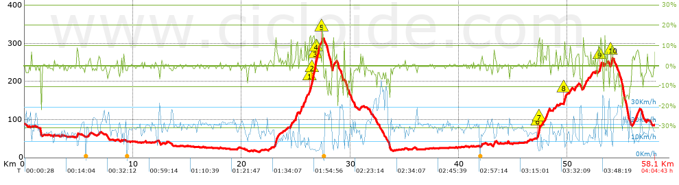
Distance in Km: 58.13
Climb in m: 808
IBP: 73 BYC

Near ...
Abrera, Castellgali, Esparreguera, Olesa De Montserrat, Santa Maria De Vilalba

 Height in m      Climb in %      Speed in Km/h      Speed < 2 Km/h

Climbs > 5%

Climbs >5% Climbs >10% Climbs >15% Climbs >20% Climbs >25%
 Steep slope of 112 m.   Average slope  Distances  Download as waypoint
1
 Km 4.846  9%  112 m
 Steep slope of 347 m.  Average slope  Distances  Download as waypoint
2
 Km 23.024  8%  347 m
 Steep slope of 150 m.  Average slope  Distances  Download as waypoint
3
 Km 24.485  9%  150 m
 Steep slope of 229 m.  Average slope  Distances  Download as waypoint
4
 Km 24.959  9%  229 m
 Steep slope of 157 m.  Average slope  Distances  Download as waypoint
5
 Km 25.379  10%  157 m
 Steep slope of 194 m.  Average slope  Distances  Download as waypoint
6
 Km 25.664  6%  194 m
 Steep slope of 101 m.  Average slope  Distances  Download as waypoint
7
 Km 25.977  7%  101 m
 Steep slope of 1015 m.  Average slope  Distances  Download as waypoint
8
 Km 26.234  14%  150 m
9
 Km 26.385  9%  109 m
10
 Km 26.494  12%  274 m
11
 Km 26.768  16%  109 m
12
 Km 26.877  14%  261 m
13
 Km 27.138  9%  112 m
 Steep slope of 106 m.  Average slope  Distances  Download as waypoint
14
 Km 27.397  16%  106 m
 Steep slope of 116 m.  Average slope  Distances  Download as waypoint
15
 Km 28.368  13%  116 m
 Steep slope of 138 m.  Average slope  Distances  Download as waypoint
16
 Km 43.18  8%  138 m
 Steep slope of 218 m.  Average slope  Distances  Download as waypoint
17
 Km 47.247  8%  37 m
18
 Km 47.284  16%  109 m
19
 Km 47.393  15%  72 m
 Steep slope of 320 m.  Average slope  Distances  Download as waypoint
20
 Km 47.933  8%  320 m
 Steep slope of 215 m.  Average slope  Distances  Download as waypoint
21
 Km 49.667  8%  38 m
22
 Km 49.705  13%  106 m
23
 Km 49.811  6%  71 m
 Steep slope of 147 m.  Average slope  Distances  Download as waypoint
24
 Km 50.23  7%  147 m
 Steep slope of 115 m.  Average slope  Distances  Download as waypoint
25
 Km 50.938  6%  115 m
 Steep slope of 417 m.  Average slope  Distances  Download as waypoint
26
 Km 51.448  6%  417 m
 Steep slope of 167 m.  Average slope  Distances  Download as waypoint
27
 Km 52.08  5%  167 m
 Steep slope of 275 m.  Average slope  Distances  Download as waypoint
28
 Km 52.833  5%  133 m
29
 Km 52.966  11%  142 m
 Steep slope of 191 m.  Average slope  Distances  Download as waypoint
30
 Km 53.982  12%  156 m
31
 Km 54.138  9%  35 m
 Steep slope of 566 m.  Average slope  Distances  Download as waypoint
32
 Km 56.037  7%  566 m


Description of the route


Presence of ramps


 Climbs  Distance  % of the total  Speed  Your speed would be  Time  Your time would be
   15 - 30%  0.399  0.69  5.99  ?  0:04:00  ?
   10 - 15%  2.016  3.47  7.78  ?  0:15:33  ?
   5 - 10%  4.103  7.06  10.69  ?  0:23:02  ?
   1 - 5%  8.061  13.87  14.48  ?  0:33:24  ?
   Total*  14.579 Km  25.08 %  11.51 Km/h  ? Km/h    1:15:59 h  ? h  
 Flat
   1 - -1%  27.382 Km  47.11 %  18.54 Km/h  ? Km/h    1:28:36 h  ? h  
 Descents
   -1 - -5%  10.295  17.71  21.5  ?  0:28:44  ?
   -5 - -10%  3.51  6.04  22.28  ?  0:09:27  ?
   -10 - -15%  1.778  3.06  21.06  ?  0:05:04  ?
   -15 - -30%  0.584  1  14.91  ?  0:02:21  ?
   Total*  16.168 Km  27.81 %  21.27 Km/h  ? Km/h    0:45:36 h  ? h  
* The total has not necessarily coincide with the sum of the partials after correction of errors

How long would it take you?

How long would it take you to cover this route?
There are routes without a valid time information, but with your average stats you can assess the possible duration

PLATO PEQUEÑO to cover this route you've need a time of:   3:30:11 h 
If you sign in and have a minimum of two tracks of this same modality, you can know your time for this route, calculated from your stats..


¿Cuanto consumirá tu E-BIKE?

Entra tu E-IBP (formato n,nn)

E-IBP :   X 73 = 


 Detected activity type =  ()
 Penalization due to track conditions: 63 %   ( > 50 % = MTB, < 50 % = RDB)
 Reliability of the track: C   (808/52/0/-/-/52)
 Correction level applied to the track: 0
DIFFICULTY OF THE ROUTE
IBP = 73 BYC
According to your statistics
 Your time in motion would be: ? h
Your average speed would be: ? Km/h
 

 Total Distance: 58.13 Km
 Analysed distance: 58.13 Km
 Linear distance: 0.03 Km

 Cumulated positive ramps: 807.96 m  list of points info
 Cumulated negative ramps: 812 m
 Maximum height: 317.4 m
 Minimum height: 15.2 m
 Climbing Ratio: 5.54 %
 Descent ratio: 5.02 %
 Cumulated postive ramps per Km: 13.9 m
 Cumulated negative ramps per Km: 13.97 m

 Total time: 4:04:43 h
 Time in movement: 3:30:11 h
 According to your statistics
 Your time in motion would be: ? h  
 Stopped time: 0:34:32 h
 Maximum slope filter: ~30 %
 Minimum separation analysed: ~30 m
 Number of points: 2796   (cad. 20.79 m)
 Significant waypoints: 1406   (cad. 41.34 m / 50.29 %)

 Changes in direction per Km: 10.7
 Changes in direction > 5º por Km: 7.16
 Cumulated straight stretches: 13.188 Km
 Straight stretches per Km: 226.87 m
 Penalized slope changes: 7
 Penalized slope changes per Km: 0.12

 Average speed in total: 14.25 Km/h
 Average speed while moving: 16.59 Km/h
 According to your statistics
 Your average speed would be: ? Km/h  
 Maximum sustained speed: 44.13 Km/h


Comments

You can be the first one in commenting this route

 
My comments
:
Add comment  (Registered users)
 
Notify me answers to my comment  Do not notify answers to my comment


Share this route with a friend

Your friend will receive a message with a link to this page:
will see your email and your user name if you do it as registered user.


Write here your name (optional)

E-mail address of your friend(s). You can include various addresses separated by commas

Text or comment (optional) maximum 255 characters long, 255 Available characters

As a non registered users you need to fill-in the captcha text.
  Change image
Type the image characters.
 
 Share with a friend


Visited history

Delete history

Marked routes for review later or compare

My favorites


  Notify anomaly in this route Share in Facebook