ZZ-06 Ainsa : trilogía de san Vicente

MTB
MTB
Ref..: 808252
Published: 01/09/2019
Performed: 29/08/2019
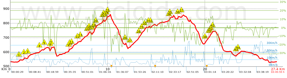
Distance in Km: 27.44
Climb in m: 937
IBP: 78 BYC

charlotte debarle
237 published routes

Add to my Group or Club

 Height in m      Climb in %      Speed in Km/h      Speed < 2 Km/h

Climbs > 5%

Climbs >5% Climbs >10% Climbs >15% Climbs >20% Climbs >25%
 Steep slope of 213 m.   Average slope  Distances  Download as waypoint
1
 Km 0.805  7%  213 m
 Steep slope of 115 m.  Average slope  Distances  Download as waypoint
2
 Km 1.341  10%  115 m
 Steep slope of 214 m.  Average slope  Distances  Download as waypoint
3
 Km 1.773  10%  214 m
 Steep slope of 373 m.  Average slope  Distances  Download as waypoint
4
 Km 2.961  6%  373 m
 Steep slope of 151 m.  Average slope  Distances  Download as waypoint
5
 Km 3.45  6%  151 m
 Steep slope of 141 m.  Average slope  Distances  Download as waypoint
6
 Km 4.083  17%  107 m
7
 Km 4.19  9%  34 m
 Steep slope of 177 m.  Average slope  Distances  Download as waypoint
8
 Km 5.921  7%  38 m
9
 Km 5.96  13%  103 m
10
 Km 6.063  7%  36 m
 Steep slope of 264 m.  Average slope  Distances  Download as waypoint
11
 Km 6.244  10%  264 m
 Steep slope of 142 m.  Average slope  Distances  Download as waypoint
12
 Km 6.812  8%  142 m
 Steep slope of 505 m.  Average slope  Distances  Download as waypoint
13
 Km 7.184  7%  505 m
 Steep slope of 271 m.  Average slope  Distances  Download as waypoint
14
 Km 7.886  9%  72 m
15
 Km 7.957  11%  114 m
16
 Km 8.071  10%  85 m
 Steep slope of 436 m.  Average slope  Distances  Download as waypoint
17
 Km 8.388  10%  212 m
18
 Km 8.6  17%  119 m
19
 Km 8.719  15%  33 m
20
 Km 8.753  15%  72 m
 Steep slope of 153 m.  Average slope  Distances  Download as waypoint
21
 Km 9.435  13%  111 m
22
 Km 9.546  6%  42 m
 Steep slope of 345 m.  Average slope  Distances  Download as waypoint
23
 Km 9.712  9%  109 m
24
 Km 9.821  14%  116 m
25
 Km 9.937  7%  120 m
 Steep slope of 114 m.  Average slope  Distances  Download as waypoint
26
 Km 11.741  12%  114 m
 Steep slope of 1672 m.  Average slope  Distances  Download as waypoint
27
 Km 12.255  7%  924 m
28
 Km 13.179  11%  277 m
29
 Km 13.456  8%  352 m
30
 Km 13.808  11%  119 m
 Steep slope of 107 m.  Average slope  Distances  Download as waypoint
31
 Km 14.161  8%  107 m
 Steep slope of 265 m.  Average slope  Distances  Download as waypoint
32
 Km 14.402  6%  265 m
 Steep slope of 275 m.  Average slope  Distances  Download as waypoint
33
 Km 16.254  9%  38 m
34
 Km 16.292  14%  100 m
35
 Km 16.392  7%  137 m
 Steep slope of 139 m.  Average slope  Distances  Download as waypoint
36
 Km 17.142  12%  139 m
 Steep slope of 178 m.  Average slope  Distances  Download as waypoint
37
 Km 17.594  7%  178 m
 Steep slope of 876 m.  Average slope  Distances  Download as waypoint
38
 Km 19.915  9%  427 m
39
 Km 20.342  10%  156 m
40
 Km 20.498  11%  112 m
41
 Km 20.61  11%  106 m
42
 Km 20.716  11%  75 m
 Steep slope of 106 m.  Average slope  Distances  Download as waypoint
43
 Km 23.182  8%  106 m
 Steep slope of 228 m.  Average slope  Distances  Download as waypoint
44
 Km 23.401  6%  228 m


Description of the route


Presence of ramps


 Climbs  Distance  % of the total  Speed  Your speed would be  Time  Your time would be
   15 - 30%  0.542  1.97  3.98  ?  0:08:10  ?
   10 - 15%  2.051  7.48  5.71  ?  0:21:33  ?
   5 - 10%  5.776  21.05  7.07  ?  0:49:03  ?
   1 - 5%  5.813  21.19  8.04  ?  0:43:23  ?
   Total*  14.182 Km  51.69 %  6.97 Km/h  ? Km/h    2:02:09 h  ? h  
 Flat
   1 - -1%  3.34 Km  12.17 %  11.64 Km/h  ? Km/h    0:17:13 h  ? h  
 Descents
   -1 - -5%  3.961  14.44  12.3  ?  0:19:19  ?
   -5 - -10%  2.059  7.51  12.36  ?  0:10:00  ?
   -10 - -15%  1.488  5.42  11.21  ?  0:07:58  ?
   -15 - -30%  2.405  8.77  8.66  ?  0:16:40  ?
   Total*  9.914 Km  36.13 %  11.03 Km/h  ? Km/h    0:53:57 h  ? h  
* The total has not necessarily coincide with the sum of the partials after correction of errors

How long would it take you?

How long would it take you to cover this route?
There are routes without a valid time information, but with your average stats you can assess the possible duration

charlotte debarle to cover this route you've need a time of:   3:13:19 h 
If you sign in and have a minimum of two tracks of this same modality, you can know your time for this route, calculated from your stats..


¿Cuanto consumirá tu E-BIKE?

Entra tu E-IBP (formato n,nn)

E-IBP :   X 78 = 


 Detected activity type =  ()
 Penalization due to track conditions: 76 %   ( > 50 % = MTB, < 50 % = RDB)
 Reliability of the track: B   (937/65/0/-/-/65)
 Correction level applied to the track: 0
DIFFICULTY OF THE ROUTE
IBP = 78 BYC
According to your statistics
 Your time in motion would be: ? h
Your average speed would be: ? Km/h
 

 Total Distance: 27.44 Km
 Analysed distance: 27.44 Km
 Linear distance: 0.01 Km

 Cumulated positive ramps: 936.59 m  list of points info
 Cumulated negative ramps: 932.09 m
 Maximum height: 864.2 m
 Minimum height: 528.1 m
 Climbing Ratio: 6.6 %
 Descent ratio: 9.4 %
 Cumulated postive ramps per Km: 34.13 m
 Cumulated negative ramps per Km: 33.97 m

 Total time: 3:45:55 h
 Time in movement: 3:13:19 h
 According to your statistics
 Your time in motion would be: ? h  
 Stopped time: 0:32:36 h
 Maximum slope filter: ~30 %
 Minimum separation analysed: ~30 m
 Number of points: 1706   (cad. 16.08 m)
 Significant waypoints: 710   (cad. 38.64 m / 41.62 %)

 Changes in direction per Km: 11.92
 Changes in direction > 5º por Km: 9.88
 Cumulated straight stretches: 3.835 Km
 Straight stretches per Km: 139.76 m
 Penalized slope changes: 8
 Penalized slope changes per Km: 0.292

 Average speed in total: 7.29 Km/h
 Average speed while moving: 8.52 Km/h
 According to your statistics
 Your average speed would be: ? Km/h  
 Maximum sustained speed: 40.07 Km/h


Comments

You can be the first one in commenting this route

 
My comments
:
Add comment  (Registered users)
 
Notify me answers to my comment  Do not notify answers to my comment


Share this route with a friend

Your friend will receive a message with a link to this page:
will see your email and your user name if you do it as registered user.


Write here your name (optional)

E-mail address of your friend(s). You can include various addresses separated by commas

Text or comment (optional) maximum 255 characters long, 255 Available characters

As a non registered users you need to fill-in the captcha text.
  Change image
Type the image characters.
 
 Share with a friend


Visited history

Delete history

Marked routes for review later or compare

My favorites


  Notify anomaly in this route Share in Facebook