Penúltima ruta en Granada y cortita

MTB
MTB
Ref..: 789230
Published: 02/08/2019
Performed: 31/07/2019
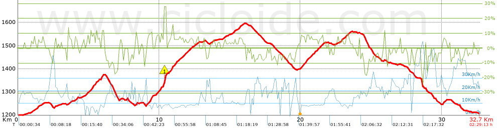
Distance in Km: 32.75
Climb in m: 835
IBP: 55 BYC

Antonio_Sánchez
179 published routes

Add to my Group or Club

 Height in m      Climb in %      Speed in Km/h      Speed < 2 Km/h

Climbs > 5%

Climbs >5% Climbs >10% Climbs >15% Climbs >20% Climbs >25%
 Steep slope of 169 m.   Average slope  Distances  Download as waypoint
1
 Km 1.267  6%  169 m
 Steep slope of 104 m.  Average slope  Distances  Download as waypoint
2
 Km 2.584  7%  104 m
 Steep slope of 216 m.  Average slope  Distances  Download as waypoint
3
 Km 3.534  7%  216 m
 Steep slope of 170 m.  Average slope  Distances  Download as waypoint
4
 Km 4.047  8%  170 m
 Steep slope of 116 m.  Average slope  Distances  Download as waypoint
5
 Km 4.87  7%  116 m
 Steep slope of 397 m.  Average slope  Distances  Download as waypoint
6
 Km 5.098  8%  397 m
 Steep slope of 365 m.  Average slope  Distances  Download as waypoint
7
 Km 5.613  6%  365 m
 Steep slope of 119 m.  Average slope  Distances  Download as waypoint
8
 Km 8.345  10%  119 m
 Steep slope of 407 m.  Average slope  Distances  Download as waypoint
9
 Km 9.101  7%  253 m
10
 Km 9.354  12%  154 m
 Steep slope of 228 m.  Average slope  Distances  Download as waypoint
11
 Km 9.734  8%  228 m
 Steep slope of 443 m.  Average slope  Distances  Download as waypoint
12
 Km 10.066  8%  228 m
13
 Km 10.293  14%  30 m
14
 Km 10.324  28%  145 m
15
 Km 10.469  15%  40 m
 Steep slope of 641 m.  Average slope  Distances  Download as waypoint
16
 Km 10.679  8%  641 m
 Steep slope of 228 m.  Average slope  Distances  Download as waypoint
17
 Km 11.432  5%  228 m
 Steep slope of 209 m.  Average slope  Distances  Download as waypoint
18
 Km 11.763  6%  209 m
 Steep slope of 263 m.  Average slope  Distances  Download as waypoint
19
 Km 12.074  6%  263 m
 Steep slope of 145 m.  Average slope  Distances  Download as waypoint
20
 Km 12.649  7%  145 m
 Steep slope of 118 m.  Average slope  Distances  Download as waypoint
21
 Km 14.507  6%  118 m
 Steep slope of 197 m.  Average slope  Distances  Download as waypoint
22
 Km 15.192  6%  197 m
 Steep slope of 235 m.  Average slope  Distances  Download as waypoint
23
 Km 15.629  7%  235 m
 Steep slope of 281 m.  Average slope  Distances  Download as waypoint
24
 Km 19.973  7%  281 m
 Steep slope of 281 m.  Average slope  Distances  Download as waypoint
25
 Km 20.351  7%  281 m
 Steep slope of 822 m.  Average slope  Distances  Download as waypoint
26
 Km 20.737  6%  822 m
 Steep slope of 181 m.  Average slope  Distances  Download as waypoint
27
 Km 22.786  7%  181 m
 Steep slope of 299 m.  Average slope  Distances  Download as waypoint
28
 Km 23.171  6%  299 m
 Steep slope of 241 m.  Average slope  Distances  Download as waypoint
29
 Km 30.06  7%  241 m


Description of the route


Presence of ramps


 Climbs  Distance  % of the total  Speed  Your speed would be  Time  Your time would be
   15 - 30%  0.209  0.64  8.86  ?  0:01:25  ?
   10 - 15%  0.779  2.38  8.63  ?  0:05:25  ?
   5 - 10%  6.958  21.25  9.75  ?  0:42:49  ?
   1 - 5%  5.716  17.45  11.83  ?  0:29:00  ?
   Total*  13.662 Km  41.72 %  10.42 Km/h  ? Km/h    1:18:39 h  ? h  
 Flat
   1 - -1%  7.081 Km  21.62 %  16.69 Km/h  ? Km/h    0:25:27 h  ? h  
 Descents
   -1 - -5%  5.228  15.96  19.52  ?  0:16:04  ?
   -5 - -10%  4.831  14.75  23.31  ?  0:12:26  ?
   -10 - -15%  1.385  4.23  23.74  ?  0:03:30  ?
   -15 - -30%  0.56  1.71  22.91  ?  0:01:28  ?
   Total*  12.004 Km  36.66 %  21.52 Km/h  ? Km/h    0:33:28 h  ? h  
* The total has not necessarily coincide with the sum of the partials after correction of errors

How long would it take you?

How long would it take you to cover this route?
There are routes without a valid time information, but with your average stats you can assess the possible duration

Antonio_Sánchez to cover this route you've need a time of:   2:17:34 h 
If you sign in and have a minimum of two tracks of this same modality, you can know your time for this route, calculated from your stats..


¿Cuanto consumirá tu E-BIKE?

Entra tu E-IBP (formato n,nn)

E-IBP :   X 55 = 


 Detected activity type =  ()
 Penalization due to track conditions: 66 %   ( > 50 % = MTB, < 50 % = RDB)
 Reliability of the track: A   (835/83/0/-/-/83)
 Correction level applied to the track: 0
DIFFICULTY OF THE ROUTE
IBP = 55 BYC
According to your statistics
 Your time in motion would be: ? h
Your average speed would be: ? Km/h
 

 Total Distance: 32.75 Km
 Analysed distance: 32.75 Km
 Linear distance: 0.2 Km

 Cumulated positive ramps: 835.1 m  list of points info
 Cumulated negative ramps: 827.4 m
 Maximum height: 1597.5 m
 Minimum height: 1199.8 m
 Climbing Ratio: 6.11 %
 Descent ratio: 6.89 %
 Cumulated postive ramps per Km: 25.5 m
 Cumulated negative ramps per Km: 25.26 m

 Total time: 2:29:13 h
 Time in movement: 2:17:34 h
 According to your statistics
 Your time in motion would be: ? h  
 Stopped time: 0:11:39 h
 Maximum slope filter: ~30 %
 Minimum separation analysed: ~30 m
 Number of points: 2294   (cad. 14.28 m)
 Significant waypoints: 902   (cad. 36.31 m / 39.32 %)

 Changes in direction per Km: 9.68
 Changes in direction > 5º por Km: 6.75
 Cumulated straight stretches: 8.384 Km
 Straight stretches per Km: 256 m
 Penalized slope changes: 8
 Penalized slope changes per Km: 0.244

 Average speed in total: 13.17 Km/h
 Average speed while moving: 14.28 Km/h
 According to your statistics
 Your average speed would be: ? Km/h  
 Maximum sustained speed: 61.13 Km/h


Comments

You can be the first one in commenting this route

 
My comments
:
Add comment  (Registered users)
 
Notify me answers to my comment  Do not notify answers to my comment


Share this route with a friend

Your friend will receive a message with a link to this page:
will see your email and your user name if you do it as registered user.


Write here your name (optional)

E-mail address of your friend(s). You can include various addresses separated by commas

Text or comment (optional) maximum 255 characters long, 255 Available characters

As a non registered users you need to fill-in the captcha text.
  Change image
Type the image characters.
 
 Share with a friend


Visited history

Delete history

Marked routes for review later or compare

My favorites


  Notify anomaly in this route Share in Facebook