Parque Tecnologico De La Salud (Armilla) (Granada)

MTB
MTB
Ref..: 773020
Published: 15/07/2019
Performed: 13/07/2019
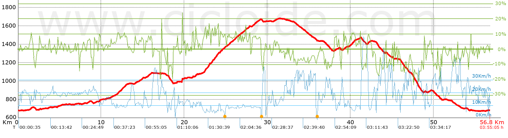
Distance in Km: 56.8
Climb in m: 1611
IBP: 111 BYC

Near ...
Armilla, Cajar, Granada, Parque Tecnologico De La Salud (Armilla), Parque Tecnologico De La Salud (La Zubia)

 Height in m      Climb in %      Speed in Km/h      Speed < 2 Km/h

Climbs > 5%

Climbs >5% Climbs >10% Climbs >15% Climbs >20% Climbs >25%
 Steep slope of 289 m.   Average slope  Distances  Download as waypoint
1
 Km 1.398  8%  289 m
 Steep slope of 105 m.  Average slope  Distances  Download as waypoint
2
 Km 2.489  7%  105 m
 Steep slope of 138 m.  Average slope  Distances  Download as waypoint
3
 Km 4.692  7%  138 m
 Steep slope of 414 m.  Average slope  Distances  Download as waypoint
4
 Km 8.276  6%  414 m
 Steep slope of 152 m.  Average slope  Distances  Download as waypoint
5
 Km 9.137  6%  152 m
 Steep slope of 105 m.  Average slope  Distances  Download as waypoint
6
 Km 9.4  6%  105 m
 Steep slope of 140 m.  Average slope  Distances  Download as waypoint
7
 Km 9.729  13%  140 m
 Steep slope of 96 m.  Average slope  Distances  Download as waypoint
8
 Km 11.273  5%  96 m
 Steep slope of 1311 m.  Average slope  Distances  Download as waypoint
9
 Km 11.782  7%  147 m
10
 Km 11.929  11%  135 m
11
 Km 12.064  9%  1029 m
 Steep slope of 179 m.  Average slope  Distances  Download as waypoint
12
 Km 14.037  8%  179 m
 Steep slope of 517 m.  Average slope  Distances  Download as waypoint
13
 Km 14.486  7%  517 m
 Steep slope of 544 m.  Average slope  Distances  Download as waypoint
14
 Km 15.562  8%  544 m
 Steep slope of 146 m.  Average slope  Distances  Download as waypoint
15
 Km 19.068  9%  146 m
 Steep slope of 166 m.  Average slope  Distances  Download as waypoint
16
 Km 19.676  20%  166 m
 Steep slope of 99 m.  Average slope  Distances  Download as waypoint
17
 Km 19.952  7%  99 m
 Steep slope of 137 m.  Average slope  Distances  Download as waypoint
18
 Km 20.942  11%  102 m
19
 Km 21.043  12%  35 m
 Steep slope of 244 m.  Average slope  Distances  Download as waypoint
20
 Km 21.325  10%  244 m
 Steep slope of 866 m.  Average slope  Distances  Download as waypoint
21
 Km 22.217  7%  143 m
22
 Km 22.361  12%  104 m
23
 Km 22.465  16%  100 m
24
 Km 22.565  9%  147 m
25
 Km 22.712  10%  154 m
26
 Km 22.866  13%  38 m
27
 Km 22.905  17%  144 m
28
 Km 23.049  13%  36 m
 Steep slope of 945 m.  Average slope  Distances  Download as waypoint
29
 Km 23.192  6%  38 m
30
 Km 23.23  13%  217 m
31
 Km 23.447  9%  107 m
32
 Km 23.554  14%  139 m
33
 Km 23.693  9%  109 m
34
 Km 23.802  14%  294 m
35
 Km 24.096  8%  41 m
 Steep slope of 768 m.  Average slope  Distances  Download as waypoint
36
 Km 24.244  5%  35 m
37
 Km 24.28  12%  107 m
38
 Km 24.386  8%  626 m
 Steep slope of 1843 m.  Average slope  Distances  Download as waypoint
39
 Km 25.115  8%  1014 m
40
 Km 26.13  10%  107 m
41
 Km 26.237  8%  722 m
 Steep slope of 767 m.  Average slope  Distances  Download as waypoint
42
 Km 27.065  8%  767 m
 Steep slope of 1047 m.  Average slope  Distances  Download as waypoint
43
 Km 28.146  8%  1047 m
 Steep slope of 172 m.  Average slope  Distances  Download as waypoint
44
 Km 30.73  6%  172 m
 Steep slope of 208 m.  Average slope  Distances  Download as waypoint
45
 Km 31.012  5%  208 m
 Steep slope of 253 m.  Average slope  Distances  Download as waypoint
46
 Km 38.047  8%  253 m
 Steep slope of 112 m.  Average slope  Distances  Download as waypoint
47
 Km 38.491  7%  112 m
 Steep slope of 403 m.  Average slope  Distances  Download as waypoint
48
 Km 39.105  8%  403 m
 Steep slope of 793 m.  Average slope  Distances  Download as waypoint
49
 Km 39.753  7%  357 m
50
 Km 40.109  11%  118 m
51
 Km 40.227  8%  107 m
52
 Km 40.334  12%  141 m
53
 Km 40.475  7%  70 m
 Steep slope of 106 m.  Average slope  Distances  Download as waypoint
54
 Km 41.069  10%  106 m
 Steep slope of 394 m.  Average slope  Distances  Download as waypoint
55
 Km 41.975  8%  394 m
 Steep slope of 108 m.  Average slope  Distances  Download as waypoint
56
 Km 44.152  6%  108 m
 Steep slope of 104 m.  Average slope  Distances  Download as waypoint
57
 Km 45.244  6%  104 m
 Steep slope of 144 m.  Average slope  Distances  Download as waypoint
58
 Km 48.801  9%  144 m
 Steep slope of 175 m.  Average slope  Distances  Download as waypoint
59
 Km 49.414  7%  175 m


Description of the route


Presence of ramps


 Climbs  Distance  % of the total  Speed  Your speed would be  Time  Your time would be
   15 - 30%  0.761  1.34  9.05  ?  0:05:03  ?
   10 - 15%  2.505  4.41  8.21  ?  0:18:18  ?
   5 - 10%  11.549  20.33  11.17  ?  1:02:02  ?
   1 - 5%  11.898  20.95  14.5  ?  0:49:13  ?
   Total*  26.713 Km  47.03 %  11.91 Km/h  ? Km/h    2:14:36 h  ? h  
 Flat
   1 - -1%  7.916 Km  13.94 %  18.27 Km/h  ? Km/h    0:26:00 h  ? h  
 Descents
   -1 - -5%  8.725  15.36  20.2  ?  0:25:55  ?
   -5 - -10%  7.65  13.47  26.23  ?  0:17:30  ?
   -10 - -15%  4.049  7.13  24.3  ?  0:10:00  ?
   -15 - -30%  1.748  3.08  20.37  ?  0:05:09  ?
   Total*  22.173 Km  39.04 %  22.72 Km/h  ? Km/h    0:58:34 h  ? h  
* The total has not necessarily coincide with the sum of the partials after correction of errors

How long would it take you?

How long would it take you to cover this route?
There are routes without a valid time information, but with your average stats you can assess the possible duration

Luis_Casillas_del_Collado to cover this route you've need a time of:   3:39:10 h 
If you sign in and have a minimum of two tracks of this same modality, you can know your time for this route, calculated from your stats..


¿Cuanto consumirá tu E-BIKE?

Entra tu E-IBP (formato n,nn)

E-IBP :   X 111 = 


 Detected activity type =  ()
 Penalization due to track conditions: 67 %   ( > 50 % = MTB, < 50 % = RDB)
 Reliability of the track: B   (1611/70/0/-/-/70)
 Correction level applied to the track: 0
DIFFICULTY OF THE ROUTE
IBP = 111 BYC
According to your statistics
 Your time in motion would be: ? h
Your average speed would be: ? Km/h
 

 Total Distance: 56.8 Km
 Analysed distance: 56.8 Km
 Linear distance: 0.01 Km

 Cumulated positive ramps: 1610.9 m  list of points info
 Cumulated negative ramps: 1607 m
 Maximum height: 1679.6 m
 Minimum height: 669.6 m
 Climbing Ratio: 6.03 %
 Descent ratio: 7.25 %
 Cumulated postive ramps per Km: 28.36 m
 Cumulated negative ramps per Km: 28.29 m

 Total time: 3:55:05 h
 Time in movement: 3:39:10 h
 According to your statistics
 Your time in motion would be: ? h  
 Stopped time: 0:15:55 h
 Maximum slope filter: ~30 %
 Minimum separation analysed: ~30 m
 Number of points: 4458   (cad. 12.74 m)
 Significant waypoints: 1577   (cad. 36.02 m / 35.37 %)

 Changes in direction per Km: 12.02
 Changes in direction > 5º por Km: 8.29
 Cumulated straight stretches: 9.858 Km
 Straight stretches per Km: 173.56 m
 Penalized slope changes: 13
 Penalized slope changes per Km: 0.229

 Average speed in total: 14.5 Km/h
 Average speed while moving: 15.55 Km/h
 According to your statistics
 Your average speed would be: ? Km/h  
 Maximum sustained speed: 65.3 Km/h


Comments

You can be the first one in commenting this route

 
My comments
:
Add comment  (Registered users)
 
Notify me answers to my comment  Do not notify answers to my comment


Share this route with a friend

Your friend will receive a message with a link to this page:
will see your email and your user name if you do it as registered user.


Write here your name (optional)

E-mail address of your friend(s). You can include various addresses separated by commas

Text or comment (optional) maximum 255 characters long, 255 Available characters

As a non registered users you need to fill-in the captcha text.
  Change image
Type the image characters.
 
 Share with a friend


Visited history

Delete history

Marked routes for review later or compare

My favorites


  Notify anomaly in this route Share in Facebook