190616 IX Desafio Oviedo BTT Las Regueras-Oviedo

MTB
MTB
Ref..: 754398
Published: 27/06/2019
Performed: 16/06/2019
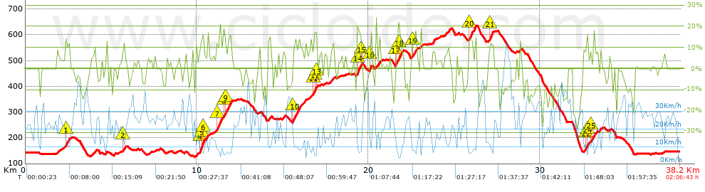
Distance in Km: 38.16
Climb in m: 1230
IBP: 120 BYC

Near ...
Abarrio, Ables, Aguera (Llanera), Andorcio, Arroyo (Llanera), Bauro
Olbap_AG
Author: Olbap_AG
358 published routes

Add to my Group or Club

 Height in m      Climb in %      Speed in Km/h      Speed < 2 Km/h

Climbs > 5%

Climbs >5% Climbs >10% Climbs >15% Climbs >20% Climbs >25%
 Steep slope of 134 m.   Average slope  Distances  Download as waypoint
1
 Km 1.84  7%  134 m
 Steep slope of 369 m.  Average slope  Distances  Download as waypoint
2
 Km 2.28  7%  33 m
3
 Km 2.313  12%  223 m
4
 Km 2.535  8%  113 m
 Steep slope of 279 m.  Average slope  Distances  Download as waypoint
5
 Km 3.827  8%  279 m
 Steep slope of 111 m.  Average slope  Distances  Download as waypoint
6
 Km 4.676  9%  111 m
 Steep slope of 193 m.  Average slope  Distances  Download as waypoint
7
 Km 5.647  6%  46 m
8
 Km 5.693  14%  105 m
9
 Km 5.797  7%  42 m
 Steep slope of 114 m.  Average slope  Distances  Download as waypoint
10
 Km 7.137  5%  114 m
 Steep slope of 123 m.  Average slope  Distances  Download as waypoint
11
 Km 7.526  6%  123 m
 Steep slope of 488 m.  Average slope  Distances  Download as waypoint
12
 Km 9.914  7%  239 m
13
 Km 10.153  14%  36 m
14
 Km 10.189  15%  73 m
15
 Km 10.262  19%  106 m
16
 Km 10.368  21%  34 m
 Steep slope of 279 m.  Average slope  Distances  Download as waypoint
17
 Km 10.438  5%  134 m
18
 Km 10.572  9%  145 m
 Steep slope of 329 m.  Average slope  Distances  Download as waypoint
19
 Km 11.092  7%  42 m
20
 Km 11.135  16%  287 m
 Steep slope of 413 m.  Average slope  Distances  Download as waypoint
21
 Km 11.545  16%  109 m
22
 Km 11.654  13%  304 m
 Steep slope of 223 m.  Average slope  Distances  Download as waypoint
23
 Km 14.1  9%  36 m
24
 Km 14.136  9%  107 m
25
 Km 14.244  13%  80 m
 Steep slope of 162 m.  Average slope  Distances  Download as waypoint
26
 Km 14.988  10%  162 m
 Steep slope of 762 m.  Average slope  Distances  Download as waypoint
27
 Km 15.557  9%  41 m
28
 Km 15.597  13%  403 m
29
 Km 16  8%  318 m
 Steep slope of 160 m.  Average slope  Distances  Download as waypoint
30
 Km 16.432  6%  160 m
 Steep slope of 317 m.  Average slope  Distances  Download as waypoint
31
 Km 16.694  8%  111 m
32
 Km 16.804  12%  33 m
33
 Km 16.837  14%  101 m
34
 Km 16.938  19%  72 m
 Steep slope of 249 m.  Average slope  Distances  Download as waypoint
35
 Km 17.781  9%  249 m
 Steep slope of 321 m.  Average slope  Distances  Download as waypoint
36
 Km 19.321  17%  216 m
37
 Km 19.537  18%  66 m
38
 Km 19.603  6%  39 m
 Steep slope of 138 m.  Average slope  Distances  Download as waypoint
39
 Km 20.077  19%  99 m
40
 Km 20.176  6%  39 m
 Steep slope of 186 m.  Average slope  Distances  Download as waypoint
41
 Km 20.606  9%  186 m
 Steep slope of 498 m.  Average slope  Distances  Download as waypoint
42
 Km 21.555  10%  188 m
43
 Km 21.742  18%  108 m
44
 Km 21.85  11%  202 m
 Steep slope of 320 m.  Average slope  Distances  Download as waypoint
45
 Km 22.478  7%  38 m
46
 Km 22.517  10%  209 m
47
 Km 22.726  17%  73 m
 Steep slope of 122 m.  Average slope  Distances  Download as waypoint
48
 Km 23.037  11%  122 m
 Steep slope of 150 m.  Average slope  Distances  Download as waypoint
49
 Km 23.721  10%  150 m
 Steep slope of 373 m.  Average slope  Distances  Download as waypoint
50
 Km 24.431  8%  373 m
 Steep slope of 106 m.  Average slope  Distances  Download as waypoint
51
 Km 25.134  8%  106 m
 Steep slope of 423 m.  Average slope  Distances  Download as waypoint
52
 Km 25.849  14%  387 m
53
 Km 26.236  15%  36 m
 Steep slope of 244 m.  Average slope  Distances  Download as waypoint
54
 Km 27.023  9%  35 m
55
 Km 27.058  15%  209 m
 Steep slope of 765 m.  Average slope  Distances  Download as waypoint
56
 Km 32.519  8%  146 m
57
 Km 32.664  12%  72 m
58
 Km 32.737  16%  30 m
59
 Km 32.767  14%  76 m
60
 Km 32.843  6%  107 m
61
 Km 32.95  10%  221 m
62
 Km 33.171  9%  113 m
 Steep slope of 106 m.  Average slope  Distances  Download as waypoint
63
 Km 33.458  10%  106 m
 Steep slope of 117 m.  Average slope  Distances  Download as waypoint
64
 Km 34.025  5%  117 m


Description of the route


Presence of ramps


 Climbs  Distance  % of the total  Speed  Your speed would be  Time  Your time would be
   15 - 30%  1.749  4.58  7.42  ?  0:14:09  ?
   10 - 15%  3.313  8.68  9.65  ?  0:20:36  ?
   5 - 10%  5.083  13.32  14.34  ?  0:21:16  ?
   1 - 5%  4.666  12.23  18.38  ?  0:15:14  ?
   Total*  14.811 Km  38.82 %  12.47 Km/h  ? Km/h    1:11:15 h  ? h  
 Flat
   1 - -1%  9.442 Km  24.75 %  22.13 Km/h  ? Km/h    0:25:36 h  ? h  
 Descents
   -1 - -5%  3.284  8.61  27.3  ?  0:07:13  ?
   -5 - -10%  6.057  15.87  30.58  ?  0:11:53  ?
   -10 - -15%  2.896  7.59  29.53  ?  0:05:53  ?
   -15 - -30%  1.667  4.37  20.48  ?  0:04:53  ?
   Total*  13.902 Km  36.44 %  27.93 Km/h  ? Km/h    0:29:52 h  ? h  
* The total has not necessarily coincide with the sum of the partials after correction of errors

How long would it take you?

How long would it take you to cover this route?
There are routes without a valid time information, but with your average stats you can assess the possible duration

Olbap_AG to cover this route you've need a time of:   2:06:43 h 
If you sign in and have a minimum of two tracks of this same modality, you can know your time for this route, calculated from your stats..


¿Cuanto consumirá tu E-BIKE?

Entra tu E-IBP (formato n,nn)

E-IBP :   X 120 = 


 Detected activity type =  ()
 Penalization due to track conditions: 77 %   ( > 50 % = MTB, < 50 % = RDB)
 Reliability of the track: B   (1230/64/0/-/-/64)
 Correction level applied to the track: 0
DIFFICULTY OF THE ROUTE
IBP = 120 BYC
According to your statistics
 Your time in motion would be: ? h
Your average speed would be: ? Km/h
 

 Total Distance: 38.16 Km
 Analysed distance: 38.16 Km
 Linear distance: 0.02 Km

 Cumulated positive ramps: 1230.2 m  list of points info
 Cumulated negative ramps: 1226.6 m
 Maximum height: 636.6 m
 Minimum height: 125 m
 Climbing Ratio: 8.31 %
 Descent ratio: 8.82 %
 Cumulated postive ramps per Km: 32.24 m
 Cumulated negative ramps per Km: 32.14 m

 Total time: 2:06:43 h
 Time in movement: 2:06:43 h
 According to your statistics
 Your time in motion would be: ? h  
 Stopped time: 0:00:00 h
 Maximum slope filter: ~30 %
 Minimum separation analysed: ~30 m
 Number of points: 2360   (cad. 16.17 m)
 Significant waypoints: 997   (cad. 38.27 m / 42.25 %)

 Changes in direction per Km: 11.27
 Changes in direction > 5º por Km: 9.17
 Cumulated straight stretches: 3.858 Km
 Straight stretches per Km: 101.1 m
 Penalized slope changes: 12
 Penalized slope changes per Km: 0.314

 Average speed in total: 18.07 Km/h
 Average speed while moving: 18.07 Km/h
 According to your statistics
 Your average speed would be: ? Km/h  
 Maximum sustained speed: 70.91 Km/h


Comments

You can be the first one in commenting this route

 
My comments
:
Add comment  (Registered users)
 
Notify me answers to my comment  Do not notify answers to my comment


Share this route with a friend

Your friend will receive a message with a link to this page:
will see your email and your user name if you do it as registered user.


Write here your name (optional)

E-mail address of your friend(s). You can include various addresses separated by commas

Text or comment (optional) maximum 255 characters long, 255 Available characters

As a non registered users you need to fill-in the captcha text.
  Change image
Type the image characters.
 
 Share with a friend


Visited history

Delete history

Marked routes for review later or compare

My favorites


  Notify anomaly in this route Share in Facebook