Quebrantahuesos 2019 -7:34

Road
Road
Ref..: 750647
Published: 24/06/2019
Performed: 22/06/2019
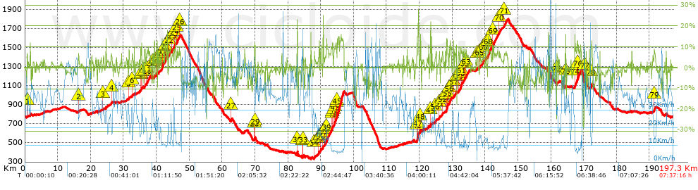
Distance in Km: 197.26
Climb in m: 4207
IBP: 287 BYC

Near ...
Aurin, Canfranc (Pueblo), Cartirana, Latas, Panticosa (Balneario), Panticosa (Pueblo)

 Height in m      Climb in %      Speed in Km/h      Speed < 2 Km/h

Climbs > 5%

Climbs >5% Climbs >10% Climbs >15% Climbs >20% Climbs >25%
 Steep slope of 138 m.   Average slope  Distances  Download as waypoint
1
 Km 0.724  6%  138 m
 Steep slope of 116 m.  Average slope  Distances  Download as waypoint
2
 Km 16.305  7%  116 m
 Steep slope of 197 m.  Average slope  Distances  Download as waypoint
3
 Km 23.796  5%  197 m
 Steep slope of 193 m.  Average slope  Distances  Download as waypoint
4
 Km 26.305  7%  193 m
 Steep slope of 237 m.  Average slope  Distances  Download as waypoint
5
 Km 31.586  8%  237 m
 Steep slope of 191 m.  Average slope  Distances  Download as waypoint
6
 Km 32.63  6%  191 m
 Steep slope of 387 m.  Average slope  Distances  Download as waypoint
7
 Km 35.242  9%  65 m
8
 Km 35.306  9%  217 m
9
 Km 35.523  11%  105 m
 Steep slope of 290 m.  Average slope  Distances  Download as waypoint
10
 Km 36.438  9%  290 m
 Steep slope of 1297 m.  Average slope  Distances  Download as waypoint
11
 Km 36.957  7%  1297 m
 Steep slope of 288 m.  Average slope  Distances  Download as waypoint
12
 Km 38.822  7%  288 m
 Steep slope of 212 m.  Average slope  Distances  Download as waypoint
13
 Km 39.361  9%  52 m
14
 Km 39.412  13%  160 m
 Steep slope of 295 m.  Average slope  Distances  Download as waypoint
15
 Km 40.004  8%  136 m
16
 Km 40.14  14%  159 m
 Steep slope of 242 m.  Average slope  Distances  Download as waypoint
17
 Km 40.742  7%  242 m
 Steep slope of 451 m.  Average slope  Distances  Download as waypoint
18
 Km 41.686  11%  302 m
19
 Km 41.988  10%  149 m
 Steep slope of 371 m.  Average slope  Distances  Download as waypoint
20
 Km 42.574  5%  60 m
21
 Km 42.634  12%  311 m
 Steep slope of 628 m.  Average slope  Distances  Download as waypoint
22
 Km 43.767  7%  628 m
 Steep slope of 558 m.  Average slope  Distances  Download as waypoint
23
 Km 44.712  7%  558 m
 Steep slope of 487 m.  Average slope  Distances  Download as waypoint
24
 Km 45.461  7%  487 m
 Steep slope of 664 m.  Average slope  Distances  Download as waypoint
25
 Km 46.168  7%  664 m
 Steep slope of 366 m.  Average slope  Distances  Download as waypoint
26
 Km 47.015  7%  366 m
 Steep slope of 349 m.  Average slope  Distances  Download as waypoint
27
 Km 62.659  7%  349 m
 Steep slope of 273 m.  Average slope  Distances  Download as waypoint
28
 Km 69.801  11%  204 m
29
 Km 70.005  10%  69 m
 Steep slope of 233 m.  Average slope  Distances  Download as waypoint
30
 Km 82.774  15%  233 m
 Steep slope of 190 m.  Average slope  Distances  Download as waypoint
31
 Km 84.513  7%  43 m
32
 Km 84.556  13%  117 m
33
 Km 84.673  9%  30 m
 Steep slope of 129 m.  Average slope  Distances  Download as waypoint
34
 Km 87.992  9%  129 m
 Steep slope of 422 m.  Average slope  Distances  Download as waypoint
35
 Km 89.187  6%  422 m
 Steep slope of 316 m.  Average slope  Distances  Download as waypoint
36
 Km 89.861  9%  316 m
 Steep slope of 249 m.  Average slope  Distances  Download as waypoint
37
 Km 90.686  9%  249 m
 Steep slope of 277 m.  Average slope  Distances  Download as waypoint
38
 Km 91.18  5%  277 m
 Steep slope of 2041 m.  Average slope  Distances  Download as waypoint
39
 Km 91.625  8%  1703 m
40
 Km 93.328  10%  242 m
41
 Km 93.571  11%  96 m
 Steep slope of 3020 m.  Average slope  Distances  Download as waypoint
42
 Km 93.909  8%  369 m
43
 Km 94.278  10%  415 m
44
 Km 94.694  8%  303 m
45
 Km 94.997  13%  1933 m
 Steep slope of 646 m.  Average slope  Distances  Download as waypoint
46
 Km 119.21  8%  209 m
47
 Km 119.42  16%  437 m
 Steep slope of 251 m.  Average slope  Distances  Download as waypoint
48
 Km 120.208  11%  251 m
 Steep slope of 203 m.  Average slope  Distances  Download as waypoint
49
 Km 123.324  15%  203 m
 Steep slope of 459 m.  Average slope  Distances  Download as waypoint
50
 Km 124.756  6%  459 m
 Steep slope of 282 m.  Average slope  Distances  Download as waypoint
51
 Km 125.966  9%  282 m
 Steep slope of 186 m.  Average slope  Distances  Download as waypoint
52
 Km 126.973  8%  186 m
 Steep slope of 727 m.  Average slope  Distances  Download as waypoint
53
 Km 128.151  9%  61 m
54
 Km 128.212  13%  280 m
55
 Km 128.492  10%  386 m
 Steep slope of 724 m.  Average slope  Distances  Download as waypoint
56
 Km 129.092  9%  724 m
 Steep slope of 632 m.  Average slope  Distances  Download as waypoint
57
 Km 130.309  6%  632 m
 Steep slope of 190 m.  Average slope  Distances  Download as waypoint
58
 Km 131.248  11%  190 m
 Steep slope of 320 m.  Average slope  Distances  Download as waypoint
59
 Km 131.827  7%  320 m
 Steep slope of 1072 m.  Average slope  Distances  Download as waypoint
60
 Km 132.49  12%  214 m
61
 Km 132.703  7%  858 m
 Steep slope of 237 m.  Average slope  Distances  Download as waypoint
62
 Km 133.699  8%  237 m
 Steep slope of 1024 m.  Average slope  Distances  Download as waypoint
63
 Km 134.175  7%  1024 m
 Steep slope of 207 m.  Average slope  Distances  Download as waypoint
64
 Km 137.555  6%  207 m
 Steep slope of 412 m.  Average slope  Distances  Download as waypoint
65
 Km 138.27  6%  412 m
 Steep slope of 180 m.  Average slope  Distances  Download as waypoint
66
 Km 139.401  12%  180 m
 Steep slope of 165 m.  Average slope  Distances  Download as waypoint
67
 Km 140.205  13%  165 m
 Steep slope of 1202 m.  Average slope  Distances  Download as waypoint
68
 Km 140.809  8%  1202 m
 Steep slope of 1811 m.  Average slope  Distances  Download as waypoint
69
 Km 142.246  7%  1811 m
 Steep slope of 606 m.  Average slope  Distances  Download as waypoint
70
 Km 144.191  6%  606 m
 Steep slope of 1022 m.  Average slope  Distances  Download as waypoint
71
 Km 145.703  7%  1022 m
 Steep slope of 419 m.  Average slope  Distances  Download as waypoint
72
 Km 161.759  6%  419 m
 Steep slope of 32 m.  Average slope  Distances  Download as waypoint
73
 Km 164.504  14%  32 m
 Steep slope of 1991 m.  Average slope  Distances  Download as waypoint
74
 Km 167.266  9%  615 m
75
 Km 167.881  10%  210 m
76
 Km 168.092  9%  1166 m
 Steep slope of 183 m.  Average slope  Distances  Download as waypoint
77
 Km 170.21  8%  183 m
 Steep slope of 473 m.  Average slope  Distances  Download as waypoint
78
 Km 172.123  10%  473 m
 Steep slope of 417 m.  Average slope  Distances  Download as waypoint
79
 Km 191.37  8%  417 m


Description of the route


Presence of ramps


 Climbs  Distance  % of the total  Speed  Your speed would be  Time  Your time would be
   15 - 30%  1.357  0.69  15.76  ?  0:05:10  ?
   10 - 15%  7.387  3.74  11.19  ?  0:39:37  ?
   5 - 10%  26.288  13.33  13.55  ?  1:56:22  ?
   1 - 5%  43.538  22.07  23.85  ?  1:49:33  ?
   Total*  78.57 Km  39.83 %  17.41 Km/h  ? Km/h    4:30:42 h  ? h  
 Flat
   1 - -1%  40.139 Km  20.35 %  33.67 Km/h  ? Km/h    1:11:32 h  ? h  
 Descents
   -1 - -5%  41.714  21.15  40.35  ?  1:02:02  ?
   -5 - -10%  28.733  14.57  46.18  ?  0:37:20  ?
   -10 - -15%  6.429  3.26  49.66  ?  0:07:46  ?
   -15 - -30%  1.672  0.85  40.67  ?  0:02:28  ?
   Total*  78.548 Km  39.82 %  43 Km/h  ? Km/h    1:49:36 h  ? h  
* The total has not necessarily coincide with the sum of the partials after correction of errors

How long would it take you?

How long would it take you to cover this route?
There are routes without a valid time information, but with your average stats you can assess the possible duration

Agustin_Perez_Senchermes to cover this route you've need a time of:   7:31:50 h 
If you sign in and have a minimum of two tracks of this same modality, you can know your time for this route, calculated from your stats..


¿Cuanto consumirá tu E-BIKE?

Entra tu E-IBP (formato n,nn)

E-IBP :   X 287 = 


 Detected activity type =  ()
 Penalization due to track conditions: 32 %   ( > 50 % = MTB, < 50 % = RDB)
 Reliability of the track: A   (4204/73/0/-/-/73)
 Correction level applied to the track: 0
DIFFICULTY OF THE ROUTE
IBP = 287 BYC
According to your statistics
 Your time in motion would be: ? h
Your average speed would be: ? Km/h
 

 Total Distance: 197.26 Km
 Analysed distance: 197.26 Km
 Linear distance: 0.16 Km

 Cumulated positive ramps: 4206.7 m  list of points info
 Cumulated negative ramps: 4222.9 m
 Maximum height: 1799.4 m
 Minimum height: 328.5 m
 Climbing Ratio: 5.35 %
 Descent ratio: 5.38 %
 Cumulated postive ramps per Km: 21.33 m
 Cumulated negative ramps per Km: 21.41 m

 Total time: 7:37:16 h
 Time in movement: 7:31:50 h
 According to your statistics
 Your time in motion would be: ? h  
 Stopped time: 0:05:26 h
 Maximum slope filter: ~30 %
 Minimum separation analysed: ~30 m
 Number of points: 4128   (cad. 47.79 m)
 Significant waypoints: 3409   (cad. 57.86 m / 82.58 %)

 Changes in direction per Km: 5.46
 Changes in direction > 5º por Km: 3.54
 Cumulated straight stretches: 61.326 Km
 Straight stretches per Km: 310.89 m
 Penalized slope changes: 31
 Penalized slope changes per Km: 0.157

 Average speed in total: 25.88 Km/h
 Average speed while moving: 26.19 Km/h
 According to your statistics
 Your average speed would be: ? Km/h  
 Maximum sustained speed: 74.47 Km/h


Comments

You can be the first one in commenting this route

 
My comments
:
Add comment  (Registered users)
 
Notify me answers to my comment  Do not notify answers to my comment


Share this route with a friend

Your friend will receive a message with a link to this page:
will see your email and your user name if you do it as registered user.


Write here your name (optional)

E-mail address of your friend(s). You can include various addresses separated by commas

Text or comment (optional) maximum 255 characters long, 255 Available characters

As a non registered users you need to fill-in the captcha text.
  Change image
Type the image characters.
 
 Share with a friend


Visited history

Delete history

Marked routes for review later or compare

My favorites


  Notify anomaly in this route Share in Facebook