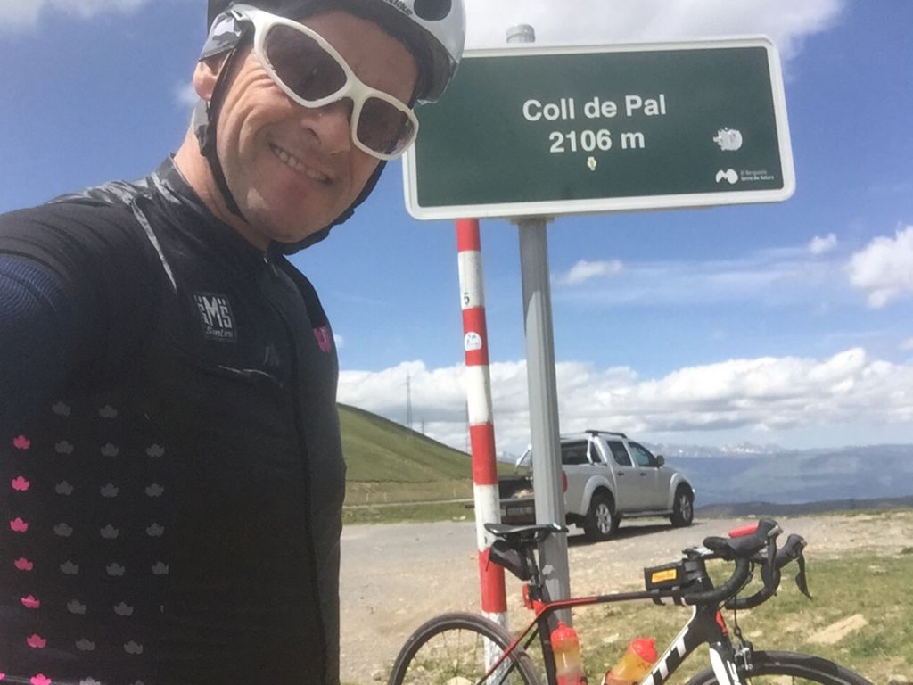
Guardiola De Bergueda (Barcelona)

MTB
MTB
Ref..: 734745
Published: 09/06/2019
Performed: 06/06/2019
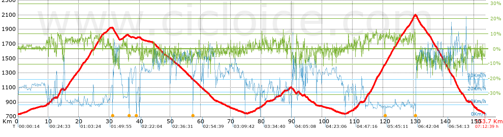
Distance in Km: 153.72
Climb in m: 3353
IBP: 216 BYC

CARLOS_BELOKI
177 published routes

Add to my Group or Club

 Height in m      Climb in %      Speed in Km/h      Speed < 2 Km/h

Climbs > 5%

Climbs >5% Climbs >10% Climbs >15% Climbs >20% Climbs >25%
 Steep slope of 155 m.   Average slope  Distances  Download as waypoint
1
 Km 9.381  6%  155 m
 Steep slope of 155 m.  Average slope  Distances  Download as waypoint
2
 Km 9.645  5%  155 m
 Steep slope of 390 m.  Average slope  Distances  Download as waypoint
3
 Km 10.059  7%  390 m
 Steep slope of 420 m.  Average slope  Distances  Download as waypoint
4
 Km 10.905  7%  420 m
 Steep slope of 214 m.  Average slope  Distances  Download as waypoint
5
 Km 11.69  7%  214 m
 Steep slope of 133 m.  Average slope  Distances  Download as waypoint
6
 Km 12.275  6%  133 m
 Steep slope of 1072 m.  Average slope  Distances  Download as waypoint
7
 Km 12.991  8%  32 m
8
 Km 13.023  10%  109 m
9
 Km 13.132  8%  530 m
10
 Km 13.662  9%  103 m
11
 Km 13.765  10%  96 m
12
 Km 13.861  12%  130 m
13
 Km 13.991  10%  72 m
 Steep slope of 204 m.  Average slope  Distances  Download as waypoint
14
 Km 14.222  6%  204 m
 Steep slope of 151 m.  Average slope  Distances  Download as waypoint
15
 Km 14.698  6%  151 m
 Steep slope of 425 m.  Average slope  Distances  Download as waypoint
16
 Km 15.62  6%  425 m
 Steep slope of 946 m.  Average slope  Distances  Download as waypoint
17
 Km 16.203  7%  946 m
 Steep slope of 484 m.  Average slope  Distances  Download as waypoint
18
 Km 17.312  7%  484 m
 Steep slope of 392 m.  Average slope  Distances  Download as waypoint
19
 Km 17.943  6%  392 m
 Steep slope of 122 m.  Average slope  Distances  Download as waypoint
20
 Km 18.456  7%  122 m
 Steep slope of 403 m.  Average slope  Distances  Download as waypoint
21
 Km 18.838  6%  403 m
 Steep slope of 188 m.  Average slope  Distances  Download as waypoint
22
 Km 19.363  6%  188 m
 Steep slope of 1159 m.  Average slope  Distances  Download as waypoint
23
 Km 19.974  7%  1159 m
 Steep slope of 339 m.  Average slope  Distances  Download as waypoint
24
 Km 21.228  7%  339 m
 Steep slope of 548 m.  Average slope  Distances  Download as waypoint
25
 Km 22.05  7%  548 m
 Steep slope of 1436 m.  Average slope  Distances  Download as waypoint
26
 Km 22.855  8%  1436 m
 Steep slope of 150 m.  Average slope  Distances  Download as waypoint
27
 Km 24.426  5%  150 m
 Steep slope of 1858 m.  Average slope  Distances  Download as waypoint
28
 Km 24.965  7%  1858 m
 Steep slope of 331 m.  Average slope  Distances  Download as waypoint
29
 Km 26.968  7%  331 m
 Steep slope of 325 m.  Average slope  Distances  Download as waypoint
30
 Km 27.459  7%  325 m
 Steep slope of 229 m.  Average slope  Distances  Download as waypoint
31
 Km 28.042  6%  229 m
 Steep slope of 236 m.  Average slope  Distances  Download as waypoint
32
 Km 29.26  6%  236 m
 Steep slope of 139 m.  Average slope  Distances  Download as waypoint
33
 Km 34.48  5%  139 m
 Steep slope of 115 m.  Average slope  Distances  Download as waypoint
34
 Km 35.463  6%  115 m
 Steep slope of 221 m.  Average slope  Distances  Download as waypoint
35
 Km 78.015  7%  221 m
 Steep slope of 97 m.  Average slope  Distances  Download as waypoint
36
 Km 79.31  6%  97 m
 Steep slope of 127 m.  Average slope  Distances  Download as waypoint
37
 Km 80.248  6%  127 m
 Steep slope of 474 m.  Average slope  Distances  Download as waypoint
38
 Km 81.132  6%  474 m
 Steep slope of 322 m.  Average slope  Distances  Download as waypoint
39
 Km 84.534  5%  322 m
 Steep slope of 222 m.  Average slope  Distances  Download as waypoint
40
 Km 86.34  5%  222 m
 Steep slope of 110 m.  Average slope  Distances  Download as waypoint
41
 Km 86.713  5%  110 m
 Steep slope of 133 m.  Average slope  Distances  Download as waypoint
42
 Km 86.977  7%  133 m
 Steep slope of 196 m.  Average slope  Distances  Download as waypoint
43
 Km 87.423  6%  196 m
 Steep slope of 280 m.  Average slope  Distances  Download as waypoint
44
 Km 89.083  7%  280 m
 Steep slope of 178 m.  Average slope  Distances  Download as waypoint
45
 Km 91.767  6%  178 m
 Steep slope of 110 m.  Average slope  Distances  Download as waypoint
46
 Km 108.619  7%  110 m
 Steep slope of 218 m.  Average slope  Distances  Download as waypoint
47
 Km 110.354  7%  218 m
 Steep slope of 204 m.  Average slope  Distances  Download as waypoint
48
 Km 111.061  8%  204 m
 Steep slope of 783 m.  Average slope  Distances  Download as waypoint
49
 Km 111.437  6%  783 m
 Steep slope of 94 m.  Average slope  Distances  Download as waypoint
50
 Km 112.329  5%  94 m
 Steep slope of 1062 m.  Average slope  Distances  Download as waypoint
51
 Km 114.067  8%  1062 m
 Steep slope of 453 m.  Average slope  Distances  Download as waypoint
52
 Km 115.452  6%  453 m
 Steep slope of 2176 m.  Average slope  Distances  Download as waypoint
53
 Km 116.058  8%  680 m
54
 Km 116.737  11%  140 m
55
 Km 116.878  8%  281 m
56
 Km 117.159  10%  108 m
57
 Km 117.266  10%  377 m
58
 Km 117.643  10%  191 m
59
 Km 117.834  9%  399 m
 Steep slope of 1841 m.  Average slope  Distances  Download as waypoint
60
 Km 118.54  8%  1841 m
 Steep slope of 2281 m.  Average slope  Distances  Download as waypoint
61
 Km 120.697  8%  2281 m
 Steep slope of 741 m.  Average slope  Distances  Download as waypoint
62
 Km 123.142  8%  741 m
 Steep slope of 1700 m.  Average slope  Distances  Download as waypoint
63
 Km 124.154  7%  1331 m
64
 Km 125.485  9%  95 m
65
 Km 125.58  9%  274 m
 Steep slope of 144 m.  Average slope  Distances  Download as waypoint
66
 Km 126.021  5%  144 m
 Steep slope of 222 m.  Average slope  Distances  Download as waypoint
67
 Km 126.404  5%  222 m
 Steep slope of 870 m.  Average slope  Distances  Download as waypoint
68
 Km 126.822  7%  870 m
 Steep slope of 212 m.  Average slope  Distances  Download as waypoint
69
 Km 127.806  6%  212 m
 Steep slope of 174 m.  Average slope  Distances  Download as waypoint
70
 Km 128.442  8%  174 m
 Steep slope of 669 m.  Average slope  Distances  Download as waypoint
71
 Km 128.759  7%  669 m
 Steep slope of 646 m.  Average slope  Distances  Download as waypoint
72
 Km 129.546  8%  253 m
73
 Km 129.799  10%  205 m
74
 Km 130.004  8%  188 m
 Steep slope of 296 m.  Average slope  Distances  Download as waypoint
75
 Km 130.302  7%  296 m


Description of the route


Presence of ramps


 Climbs  Distance  % of the total  Speed  Your speed would be  Time  Your time would be
   15 - 30%  0  0  0  ?  0:00:00  ?
   10 - 15%  2.927  1.9  10  ?  0:17:34  ?
   5 - 10%  30.177  19.63  12.39  ?  2:26:05  ?
   1 - 5%  32.487  21.13  20.55  ?  1:34:50  ?
   Total*  65.591 Km  42.67 %  15.23 Km/h  ? Km/h    4:18:29 h  ? h  
 Flat
   1 - -1%  23.751 Km  15.45 %  28.67 Km/h  ? Km/h    0:49:42 h  ? h  
 Descents
   -1 - -5%  36.418  23.69  36.46  ?  0:59:56  ?
   -5 - -10%  22.212  14.45  42.58  ?  0:31:18  ?
   -10 - -15%  4.891  3.18  49.46  ?  0:05:56  ?
   -15 - -30%  0.855  0.56  46.64  ?  0:01:06  ?
   Total*  64.375 Km  41.88 %  39.31 Km/h  ? Km/h    1:38:16 h  ? h  
* The total has not necessarily coincide with the sum of the partials after correction of errors

How long would it take you?

How long would it take you to cover this route?
There are routes without a valid time information, but with your average stats you can assess the possible duration

CARLOS_BELOKI to cover this route you've need a time of:   6:46:27 h 
If you sign in and have a minimum of two tracks of this same modality, you can know your time for this route, calculated from your stats..


¿Cuanto consumirá tu E-BIKE?

Entra tu E-IBP (formato n,nn)

E-IBP :   X 216 = 


 Detected activity type =  ()
 Penalization due to track conditions: 62 %   ( > 50 % = MTB, < 50 % = RDB)
 Reliability of the track: B   (3356/65/0/-/-/65)
 Correction level applied to the track: 0
DIFFICULTY OF THE ROUTE
IBP = 216 BYC
According to your statistics
 Your time in motion would be: ? h
Your average speed would be: ? Km/h
 

 Total Distance: 153.72 Km
 Analysed distance: 153.72 Km
 Linear distance: 0.03 Km

 Cumulated positive ramps: 3353.36 m  list of points info
 Cumulated negative ramps: 3344.27 m
 Maximum height: 2102 m
 Minimum height: 731.8 m
 Climbing Ratio: 5.11 %
 Descent ratio: 5.19 %
 Cumulated postive ramps per Km: 21.81 m
 Cumulated negative ramps per Km: 21.76 m

 Total time: 7:12:39 h
 Time in movement: 6:46:27 h
 According to your statistics
 Your time in motion would be: ? h  
 Stopped time: 0:26:12 h
 Maximum slope filter: ~30 %
 Minimum separation analysed: ~30 m
 Number of points: 7300   (cad. 21.06 m)
 Significant waypoints: 3667   (cad. 41.92 m / 50.23 %)

 Changes in direction per Km: 8.19
 Changes in direction > 5º por Km: 5.82
 Cumulated straight stretches: 35.708 Km
 Straight stretches per Km: 232.29 m
 Penalized slope changes: 15
 Penalized slope changes per Km: 0.098

 Average speed in total: 21.32 Km/h
 Average speed while moving: 22.69 Km/h
 According to your statistics
 Your average speed would be: ? Km/h  
 Maximum sustained speed: 76.66 Km/h


Comments

You can be the first one in commenting this route

 
My comments
:
Add comment  (Registered users)
 
Notify me answers to my comment  Do not notify answers to my comment


Share this route with a friend

Your friend will receive a message with a link to this page:
will see your email and your user name if you do it as registered user.


Write here your name (optional)

E-mail address of your friend(s). You can include various addresses separated by commas

Text or comment (optional) maximum 255 characters long, 255 Available characters

As a non registered users you need to fill-in the captcha text.
  Change image
Type the image characters.
 
 Share with a friend


Visited history

Delete history

Marked routes for review later or compare

My favorites


  Notify anomaly in this route Share in Facebook