Barcelona (Barcelona)

MTB
MTB
Ref..: 724590
Published: 30/05/2019
Performed: 28/05/2019
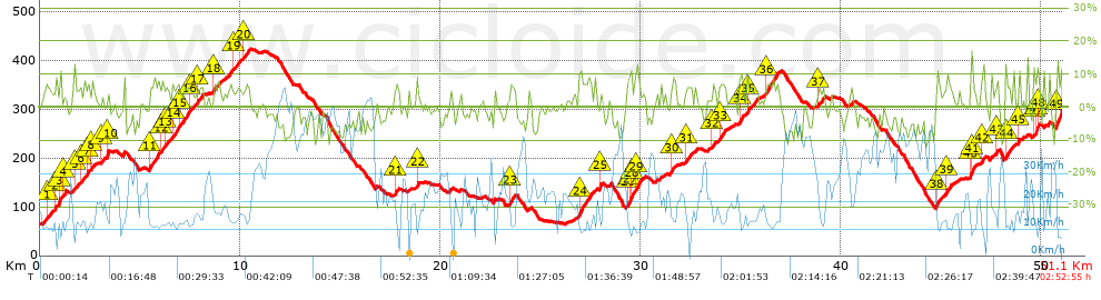
Distance in Km: 51.13
Climb in m: 1187
IBP: 72 BYC

paco_espinosa
798 published routes

Add to my Group or Club

 Height in m      Climb in %      Speed in Km/h      Speed < 2 Km/h

Climbs > 5%

Climbs >5% Climbs >10% Climbs >15% Climbs >20% Climbs >25%
 Steep slope of 212 m.   Average slope  Distances  Download as waypoint
1
 Km 0.34  6%  212 m
 Steep slope of 247 m.  Average slope  Distances  Download as waypoint
2
 Km 0.801  5%  158 m
3
 Km 0.959  11%  89 m
 Steep slope of 106 m.  Average slope  Distances  Download as waypoint
4
 Km 1.181  7%  106 m
 Steep slope of 139 m.  Average slope  Distances  Download as waypoint
5
 Km 1.733  5%  139 m
 Steep slope of 150 m.  Average slope  Distances  Download as waypoint
6
 Km 2.028  5%  150 m
 Steep slope of 109 m.  Average slope  Distances  Download as waypoint
7
 Km 2.378  8%  109 m
 Steep slope of 114 m.  Average slope  Distances  Download as waypoint
8
 Km 2.601  6%  114 m
 Steep slope of 95 m.  Average slope  Distances  Download as waypoint
9
 Km 3.099  6%  95 m
 Steep slope of 93 m.  Average slope  Distances  Download as waypoint
10
 Km 3.356  15%  93 m
 Steep slope of 447 m.  Average slope  Distances  Download as waypoint
11
 Km 5.47  6%  447 m
 Steep slope of 135 m.  Average slope  Distances  Download as waypoint
12
 Km 6.034  6%  135 m
 Steep slope of 146 m.  Average slope  Distances  Download as waypoint
13
 Km 6.283  6%  146 m
 Steep slope of 278 m.  Average slope  Distances  Download as waypoint
14
 Km 6.617  6%  278 m
 Steep slope of 389 m.  Average slope  Distances  Download as waypoint
15
 Km 7.015  6%  389 m
 Steep slope of 150 m.  Average slope  Distances  Download as waypoint
16
 Km 7.503  5%  150 m
 Steep slope of 223 m.  Average slope  Distances  Download as waypoint
17
 Km 7.876  6%  223 m
 Steep slope of 224 m.  Average slope  Distances  Download as waypoint
18
 Km 8.66  6%  224 m
 Steep slope of 123 m.  Average slope  Distances  Download as waypoint
19
 Km 9.692  5%  123 m
 Steep slope of 299 m.  Average slope  Distances  Download as waypoint
20
 Km 10.186  6%  299 m
 Steep slope of 158 m.  Average slope  Distances  Download as waypoint
21
 Km 17.742  6%  158 m
 Steep slope of 109 m.  Average slope  Distances  Download as waypoint
22
 Km 18.841  8%  109 m
 Steep slope of 267 m.  Average slope  Distances  Download as waypoint
23
 Km 23.495  7%  267 m
 Steep slope of 598 m.  Average slope  Distances  Download as waypoint
24
 Km 26.931  8%  598 m
 Steep slope of 106 m.  Average slope  Distances  Download as waypoint
25
 Km 27.962  10%  106 m
 Steep slope of 259 m.  Average slope  Distances  Download as waypoint
26
 Km 29.346  8%  113 m
27
 Km 29.458  11%  105 m
28
 Km 29.563  12%  41 m
 Steep slope of 277 m.  Average slope  Distances  Download as waypoint
29
 Km 29.717  8%  277 m
 Steep slope of 265 m.  Average slope  Distances  Download as waypoint
30
 Km 31.525  6%  265 m
 Steep slope of 226 m.  Average slope  Distances  Download as waypoint
31
 Km 32.282  5%  226 m
 Steep slope of 142 m.  Average slope  Distances  Download as waypoint
32
 Km 33.583  7%  142 m
 Steep slope of 300 m.  Average slope  Distances  Download as waypoint
33
 Km 33.927  7%  300 m
 Steep slope of 215 m.  Average slope  Distances  Download as waypoint
34
 Km 34.939  8%  215 m
 Steep slope of 241 m.  Average slope  Distances  Download as waypoint
35
 Km 35.317  6%  241 m
 Steep slope of 558 m.  Average slope  Distances  Download as waypoint
36
 Km 36.29  7%  558 m
 Steep slope of 253 m.  Average slope  Distances  Download as waypoint
37
 Km 38.907  6%  253 m
 Steep slope of 220 m.  Average slope  Distances  Download as waypoint
38
 Km 44.809  9%  220 m
 Steep slope of 301 m.  Average slope  Distances  Download as waypoint
39
 Km 45.238  6%  301 m
 Steep slope of 287 m.  Average slope  Distances  Download as waypoint
40
 Km 46.481  14%  106 m
41
 Km 46.587  6%  181 m
 Steep slope of 117 m.  Average slope  Distances  Download as waypoint
42
 Km 47.023  5%  117 m
 Steep slope of 108 m.  Average slope  Distances  Download as waypoint
43
 Km 47.769  7%  108 m
 Steep slope of 352 m.  Average slope  Distances  Download as waypoint
44
 Km 48.228  7%  352 m
 Steep slope of 185 m.  Average slope  Distances  Download as waypoint
45
 Km 48.867  5%  185 m
 Steep slope of 281 m.  Average slope  Distances  Download as waypoint
46
 Km 49.627  6%  132 m
47
 Km 49.759  12%  114 m
48
 Km 49.873  6%  35 m
 Steep slope of 215 m.  Average slope  Distances  Download as waypoint
49
 Km 50.808  11%  215 m


Description of the route


Presence of ramps


 Climbs  Distance  % of the total  Speed  Your speed would be  Time  Your time would be
   15 - 30%  0.134  0.26  10.51  ?  0:00:46  ?
   10 - 15%  1.389  2.72  9.4  ?  0:08:52  ?
   5 - 10%  9.669  18.91  12.85  ?  0:45:09  ?
   1 - 5%  11.392  22.28  15.73  ?  0:43:27  ?
   Total*  22.585 Km  44.17 %  13.79 Km/h  ? Km/h    1:38:14 h  ? h  
 Flat
   1 - -1%  9.191 Km  17.98 %  23.02 Km/h  ? Km/h    0:23:57 h  ? h  
 Descents
   -1 - -5%  10.957  21.43  28.1  ?  0:23:24  ?
   -5 - -10%  7.586  14.84  39.69  ?  0:11:28  ?
   -10 - -15%  0.774  1.51  32.42  ?  0:01:26  ?
   -15 - -30%  0.033  0.06  29.5  ?  0:00:04  ?
   Total*  19.351 Km  37.85 %  31.93 Km/h  ? Km/h    0:36:22 h  ? h  
* The total has not necessarily coincide with the sum of the partials after correction of errors

How long would it take you?

How long would it take you to cover this route?
There are routes without a valid time information, but with your average stats you can assess the possible duration

paco_espinosa to cover this route you've need a time of:   2:38:33 h 
If you sign in and have a minimum of two tracks of this same modality, you can know your time for this route, calculated from your stats..


¿Cuanto consumirá tu E-BIKE?

Entra tu E-IBP (formato n,nn)

E-IBP :   X 72 = 


 Detected activity type =  ()
 Penalization due to track conditions: 55 %   ( > 50 % = MTB, < 50 % = RDB)
 Reliability of the track: A   (1185/74/0/-/-/74)
 Correction level applied to the track: 0
DIFFICULTY OF THE ROUTE
IBP = 72 BYC
According to your statistics
 Your time in motion would be: ? h
Your average speed would be: ? Km/h
 

 Total Distance: 51.13 Km
 Analysed distance: 51.13 Km
 Linear distance: 26.15 Km

 Cumulated positive ramps: 1186.6 m  list of points info
 Cumulated negative ramps: 951.6 m
 Maximum height: 423.6 m
 Minimum height: 64 m
 Climbing Ratio: 5.25 %
 Descent ratio: 4.92 %
 Cumulated postive ramps per Km: 23.21 m
 Cumulated negative ramps per Km: 18.61 m

 Total time: 2:52:55 h
 Time in movement: 2:38:33 h
 According to your statistics
 Your time in motion would be: ? h  
 Stopped time: 0:14:22 h
 Maximum slope filter: ~30 %
 Minimum separation analysed: ~30 m
 Number of points: 3396   (cad. 15.05 m)
 Significant waypoints: 1368   (cad. 37.37 m / 40.28 %)

 Changes in direction per Km: 9.25
 Changes in direction > 5º por Km: 5.81
 Cumulated straight stretches: 14.426 Km
 Straight stretches per Km: 282.14 m
 Penalized slope changes: 9
 Penalized slope changes per Km: 0.176

 Average speed in total: 17.74 Km/h
 Average speed while moving: 19.35 Km/h
 According to your statistics
 Your average speed would be: ? Km/h  
 Maximum sustained speed: 62.59 Km/h


Comments

You can be the first one in commenting this route

 
My comments
:
Add comment  (Registered users)
 
Notify me answers to my comment  Do not notify answers to my comment


Share this route with a friend

Your friend will receive a message with a link to this page:
will see your email and your user name if you do it as registered user.


Write here your name (optional)

E-mail address of your friend(s). You can include various addresses separated by commas

Text or comment (optional) maximum 255 characters long, 255 Available characters

As a non registered users you need to fill-in the captcha text.
  Change image
Type the image characters.
 
 Share with a friend


Visited history

Delete history

Marked routes for review later or compare

My favorites


  Notify anomaly in this route Share in Facebook