Ports de la Ribagorça 2019, repte aconseguit.

Road
Road
Ref..: 719767
Published: 26/05/2019
Performed: 25/05/2019
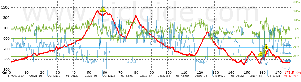
Distance in Km: 178.45
Climb in m: 3045
IBP: 200 BYC

Near ...
Bellestar (Graus), Benavente De Aragon, Graus, Torre De Esera, Ventas De Santa Lucia
Santi Dongil Diaz
926 published routes

Add to my Group or Club

 Height in m      Climb in %      Speed in Km/h      Speed < 2 Km/h

Climbs > 5%

Climbs >5% Climbs >10% Climbs >15% Climbs >20% Climbs >25%
 Steep slope of 137 m.   Average slope  Distances  Download as waypoint
1
 Km 8.311  5%  137 m
 Steep slope of 288 m.  Average slope  Distances  Download as waypoint
2
 Km 13.271  6%  288 m
 Steep slope of 314 m.  Average slope  Distances  Download as waypoint
3
 Km 14.308  6%  314 m
 Steep slope of 490 m.  Average slope  Distances  Download as waypoint
4
 Km 28.136  6%  490 m
 Steep slope of 348 m.  Average slope  Distances  Download as waypoint
5
 Km 28.762  8%  348 m
 Steep slope of 139 m.  Average slope  Distances  Download as waypoint
6
 Km 30.978  6%  139 m
 Steep slope of 166 m.  Average slope  Distances  Download as waypoint
7
 Km 33.427  5%  166 m
 Steep slope of 128 m.  Average slope  Distances  Download as waypoint
8
 Km 37.151  5%  128 m
 Steep slope of 183 m.  Average slope  Distances  Download as waypoint
9
 Km 41.964  6%  183 m
 Steep slope of 373 m.  Average slope  Distances  Download as waypoint
10
 Km 45.792  6%  373 m
 Steep slope of 319 m.  Average slope  Distances  Download as waypoint
11
 Km 46.307  6%  319 m
 Steep slope of 887 m.  Average slope  Distances  Download as waypoint
12
 Km 47.315  7%  887 m
 Steep slope of 974 m.  Average slope  Distances  Download as waypoint
13
 Km 48.862  8%  974 m
 Steep slope of 160 m.  Average slope  Distances  Download as waypoint
14
 Km 50.434  7%  160 m
 Steep slope of 1739 m.  Average slope  Distances  Download as waypoint
15
 Km 50.964  7%  1739 m
 Steep slope of 1216 m.  Average slope  Distances  Download as waypoint
16
 Km 53.421  7%  1216 m
 Steep slope of 285 m.  Average slope  Distances  Download as waypoint
17
 Km 54.751  6%  285 m
 Steep slope of 400 m.  Average slope  Distances  Download as waypoint
18
 Km 58.779  12%  126 m
19
 Km 58.905  7%  274 m
 Steep slope of 1259 m.  Average slope  Distances  Download as waypoint
20
 Km 73.686  8%  1259 m
 Steep slope of 734 m.  Average slope  Distances  Download as waypoint
21
 Km 75.07  8%  734 m
 Steep slope of 1717 m.  Average slope  Distances  Download as waypoint
22
 Km 75.961  7%  1717 m
 Steep slope of 1737 m.  Average slope  Distances  Download as waypoint
23
 Km 78.028  7%  1737 m
 Steep slope of 274 m.  Average slope  Distances  Download as waypoint
24
 Km 101.953  6%  274 m
 Steep slope of 100 m.  Average slope  Distances  Download as waypoint
25
 Km 103.087  5%  100 m
 Steep slope of 203 m.  Average slope  Distances  Download as waypoint
26
 Km 113.622  5%  203 m
 Steep slope of 143 m.  Average slope  Distances  Download as waypoint
27
 Km 115.099  7%  143 m
 Steep slope of 337 m.  Average slope  Distances  Download as waypoint
28
 Km 118.478  6%  337 m
 Steep slope of 287 m.  Average slope  Distances  Download as waypoint
29
 Km 118.928  6%  287 m
 Steep slope of 802 m.  Average slope  Distances  Download as waypoint
30
 Km 119.317  6%  802 m
 Steep slope of 344 m.  Average slope  Distances  Download as waypoint
31
 Km 120.238  7%  344 m
 Steep slope of 309 m.  Average slope  Distances  Download as waypoint
32
 Km 120.771  7%  309 m
 Steep slope of 390 m.  Average slope  Distances  Download as waypoint
33
 Km 121.261  6%  390 m
 Steep slope of 977 m.  Average slope  Distances  Download as waypoint
34
 Km 121.815  7%  977 m
 Steep slope of 239 m.  Average slope  Distances  Download as waypoint
35
 Km 122.905  8%  239 m
 Steep slope of 723 m.  Average slope  Distances  Download as waypoint
36
 Km 123.243  6%  723 m
 Steep slope of 467 m.  Average slope  Distances  Download as waypoint
37
 Km 124.414  7%  467 m
 Steep slope of 397 m.  Average slope  Distances  Download as waypoint
38
 Km 125.013  6%  397 m
 Steep slope of 742 m.  Average slope  Distances  Download as waypoint
39
 Km 148.956  6%  742 m
 Steep slope of 1144 m.  Average slope  Distances  Download as waypoint
40
 Km 149.947  7%  1144 m
 Steep slope of 197 m.  Average slope  Distances  Download as waypoint
41
 Km 151.245  6%  197 m
 Steep slope of 144 m.  Average slope  Distances  Download as waypoint
42
 Km 152.751  7%  144 m
 Steep slope of 340 m.  Average slope  Distances  Download as waypoint
43
 Km 153.421  5%  340 m
 Steep slope of 184 m.  Average slope  Distances  Download as waypoint
44
 Km 158.891  8%  184 m
 Steep slope of 910 m.  Average slope  Distances  Download as waypoint
45
 Km 159.215  7%  500 m
46
 Km 159.715  10%  102 m
47
 Km 159.817  9%  308 m
 Steep slope of 126 m.  Average slope  Distances  Download as waypoint
48
 Km 160.249  8%  126 m
 Steep slope of 1335 m.  Average slope  Distances  Download as waypoint
49
 Km 161.941  7%  35 m
50
 Km 161.976  14%  279 m
51
 Km 162.255  8%  665 m
52
 Km 162.92  10%  139 m
53
 Km 163.059  10%  217 m
 Steep slope of 584 m.  Average slope  Distances  Download as waypoint
54
 Km 163.403  7%  584 m
 Steep slope of 100 m.  Average slope  Distances  Download as waypoint
55
 Km 164.316  6%  100 m
 Steep slope of 163 m.  Average slope  Distances  Download as waypoint
56
 Km 167.263  6%  163 m


Description of the route


Presence of ramps


 Climbs  Distance  % of the total  Speed  Your speed would be  Time  Your time would be
   15 - 30%  0.106  0.06  3.54  ?  0:01:48  ?
   10 - 15%  1.755  0.98  9.66  ?  0:10:54  ?
   5 - 10%  26.042  14.59  12.96  ?  2:00:36  ?
   1 - 5%  36.633  20.53  23.02  ?  1:35:28  ?
   Total*  64.537 Km  36.17 %  16.93 Km/h  ? Km/h    3:48:46 h  ? h  
 Flat
   1 - -1%  40.227 Km  22.54 %  35.05 Km/h  ? Km/h    1:08:52 h  ? h  
 Descents
   -1 - -5%  49.683  27.84  44.38  ?  1:07:10  ?
   -5 - -10%  22.078  12.37  50.88  ?  0:26:02  ?
   -10 - -15%  1.775  0.99  49.55  ?  0:02:09  ?
   -15 - -30%  0.15  0.08  53.97  ?  0:00:10  ?
   Total*  73.686 Km  41.29 %  46.29 Km/h  ? Km/h    1:35:31 h  ? h  
* The total has not necessarily coincide with the sum of the partials after correction of errors

How long would it take you?

How long would it take you to cover this route?
There are routes without a valid time information, but with your average stats you can assess the possible duration

Santi Dongil Diaz to cover this route you've need a time of:   6:33:09 h 
If you sign in and have a minimum of two tracks of this same modality, you can know your time for this route, calculated from your stats..


¿Cuanto consumirá tu E-BIKE?

Entra tu E-IBP (formato n,nn)

E-IBP :   X 200 = 


 Detected activity type =  ()
 Penalization due to track conditions: 26 %   ( > 50 % = MTB, < 50 % = RDB)
 Reliability of the track: A   (3048/85/0/-/-/85)
 Correction level applied to the track: 0
DIFFICULTY OF THE ROUTE
IBP = 200 BYC
According to your statistics
 Your time in motion would be: ? h
Your average speed would be: ? Km/h
 

 Total Distance: 178.45 Km
 Analysed distance: 178.45 Km
 Linear distance: 0.27 Km

 Cumulated positive ramps: 3045.37 m  list of points info
 Cumulated negative ramps: 3071.97 m
 Maximum height: 1439.4 m
 Minimum height: 396.2 m
 Climbing Ratio: 4.72 %
 Descent ratio: 4.17 %
 Cumulated postive ramps per Km: 17.07 m
 Cumulated negative ramps per Km: 17.21 m

 Total time: 6:37:49 h
 Time in movement: 6:33:09 h
 According to your statistics
 Your time in motion would be: ? h  
 Stopped time: 0:04:40 h
 Maximum slope filter: ~30 %
 Minimum separation analysed: ~30 m
 Number of points: 6280   (cad. 28.42 m)
 Significant waypoints: 3810   (cad. 46.84 m / 60.67 %)

 Changes in direction per Km: 6.05
 Changes in direction > 5º por Km: 3.47
 Cumulated straight stretches: 64.45 Km
 Straight stretches per Km: 361.17 m
 Penalized slope changes: 23
 Penalized slope changes per Km: 0.129

 Average speed in total: 26.91 Km/h
 Average speed while moving: 27.23 Km/h
 According to your statistics
 Your average speed would be: ? Km/h  
 Maximum sustained speed: 73.26 Km/h


Comments

You can be the first one in commenting this route

 
My comments
:
Add comment  (Registered users)
 
Notify me answers to my comment  Do not notify answers to my comment


Share this route with a friend

Your friend will receive a message with a link to this page:
will see your email and your user name if you do it as registered user.


Write here your name (optional)

E-mail address of your friend(s). You can include various addresses separated by commas

Text or comment (optional) maximum 255 characters long, 255 Available characters

As a non registered users you need to fill-in the captcha text.
  Change image
Type the image characters.
 
 Share with a friend


Visited history

Delete history

Marked routes for review later or compare

My favorites


  Notify anomaly in this route Share in Facebook