2019-05-01 09:18

MTB
MTB
Ref..: 695840
Published: 03/05/2019
Performed: 01/05/2019
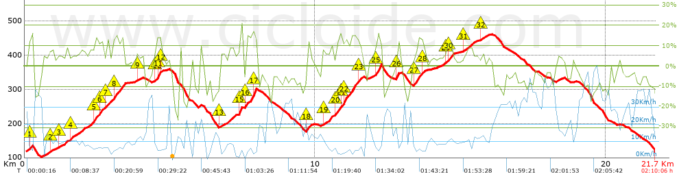
Distance in Km: 21.73
Climb in m: 828
IBP: 83 BYC

bernatekumula
163 published routes

Add to my Group or Club

 Height in m      Climb in %      Speed in Km/h      Speed < 2 Km/h

Climbs > 5%

Climbs >5% Climbs >10% Climbs >15% Climbs >20% Climbs >25%
 Steep slope of 129 m.   Average slope  Distances  Download as waypoint
1
 Km 0.129  13%  129 m
 Steep slope of 132 m.  Average slope  Distances  Download as waypoint
2
 Km 0.833  7%  132 m
 Steep slope of 214 m.  Average slope  Distances  Download as waypoint
3
 Km 1.181  5%  214 m
 Steep slope of 1070 m.  Average slope  Distances  Download as waypoint
4
 Km 1.566  7%  815 m
5
 Km 2.381  13%  213 m
6
 Km 2.594  10%  42 m
 Steep slope of 637 m.  Average slope  Distances  Download as waypoint
7
 Km 2.765  8%  255 m
8
 Km 3.021  12%  382 m
 Steep slope of 137 m.  Average slope  Distances  Download as waypoint
9
 Km 3.832  5%  137 m
 Steep slope of 254 m.  Average slope  Distances  Download as waypoint
10
 Km 4.476  7%  42 m
11
 Km 4.517  14%  170 m
12
 Km 4.687  9%  42 m
 Steep slope of 474 m.  Average slope  Distances  Download as waypoint
13
 Km 6.706  6%  474 m
 Steep slope of 174 m.  Average slope  Distances  Download as waypoint
14
 Km 7.309  7%  43 m
15
 Km 7.352  16%  131 m
 Steep slope of 343 m.  Average slope  Distances  Download as waypoint
16
 Km 7.607  14%  258 m
17
 Km 7.865  19%  85 m
 Steep slope of 175 m.  Average slope  Distances  Download as waypoint
18
 Km 9.673  11%  175 m
 Steep slope of 1297 m.  Average slope  Distances  Download as waypoint
19
 Km 10.244  7%  462 m
20
 Km 10.706  12%  123 m
21
 Km 10.829  12%  124 m
22
 Km 10.954  13%  502 m
23
 Km 11.455  8%  86 m
 Steep slope of 258 m.  Average slope  Distances  Download as waypoint
24
 Km 12.029  9%  41 m
25
 Km 12.07  14%  217 m
 Steep slope of 133 m.  Average slope  Distances  Download as waypoint
26
 Km 12.755  13%  133 m
 Steep slope of 383 m.  Average slope  Distances  Download as waypoint
27
 Km 13.377  11%  255 m
28
 Km 13.632  11%  128 m
 Steep slope of 305 m.  Average slope  Distances  Download as waypoint
29
 Km 14.44  6%  86 m
30
 Km 14.525  11%  219 m
 Steep slope of 395 m.  Average slope  Distances  Download as waypoint
31
 Km 15.092  7%  395 m
 Steep slope of 178 m.  Average slope  Distances  Download as waypoint
32
 Km 15.661  6%  178 m


Description of the route


Presence of ramps


 Climbs  Distance  % of the total  Speed  Your speed would be  Time  Your time would be
   15 - 30%  0.776  3.57  4.35  ?  0:10:42  ?
   10 - 15%  2.469  11.36  6.66  ?  0:22:14  ?
   5 - 10%  3.881  17.86  7.96  ?  0:29:14  ?
   1 - 5%  3.847  17.7  10.36  ?  0:22:17  ?
   Total*  10.973 Km  50.49 %  7.8 Km/h  ? Km/h    1:24:27 h  ? h  
 Flat
   1 - -1%  0.867 Km  3.99 %  12.39 Km/h  ? Km/h    0:04:12 h  ? h  
 Descents
   -1 - -5%  1.806  8.31  14.58  ?  0:07:26  ?
   -5 - -10%  5.495  25.28  22.74  ?  0:14:30  ?
   -10 - -15%  1.749  8.05  20.98  ?  0:05:00  ?
   -15 - -30%  0.844  3.88  12.82  ?  0:03:57  ?
   Total*  9.893 Km  45.52 %  19.22 Km/h  ? Km/h    0:30:53 h  ? h  
* The total has not necessarily coincide with the sum of the partials after correction of errors

How long would it take you?

How long would it take you to cover this route?
There are routes without a valid time information, but with your average stats you can assess the possible duration

bernatekumula to cover this route you've need a time of:   1:59:32 h 
If you sign in and have a minimum of two tracks of this same modality, you can know your time for this route, calculated from your stats..


¿Cuanto consumirá tu E-BIKE?

Entra tu E-IBP (formato n,nn)

E-IBP :   X 83 = 


 Detected activity type =  ()
 Penalization due to track conditions: 75 %   ( > 50 % = MTB, < 50 % = RDB)
 Reliability of the track: A   (828/74/0/-/-/74)
 Correction level applied to the track: 0
DIFFICULTY OF THE ROUTE
IBP = 83 BYC
According to your statistics
 Your time in motion would be: ? h
Your average speed would be: ? Km/h
 

 Total Distance: 21.73 Km
 Analysed distance: 21.73 Km
 Linear distance: 0.13 Km

 Cumulated positive ramps: 827.7 m  list of points info
 Cumulated negative ramps: 841.9 m
 Maximum height: 462.3 m
 Minimum height: 102.1 m
 Climbing Ratio: 7.54 %
 Descent ratio: 8.51 %
 Cumulated postive ramps per Km: 38.09 m
 Cumulated negative ramps per Km: 38.74 m

 Total time: 2:10:06 h
 Time in movement: 1:59:32 h
 According to your statistics
 Your time in motion would be: ? h  
 Stopped time: 0:10:34 h
 Maximum slope filter: ~30 %
 Minimum separation analysed: ~30 m
 Number of points: 962   (cad. 22.59 m)
 Significant waypoints: 488   (cad. 44.54 m / 50.73 %)

 Changes in direction per Km: 9.71
 Changes in direction > 5º por Km: 7.82
 Cumulated straight stretches: 2.354 Km
 Straight stretches per Km: 108.33 m
 Penalized slope changes: 7
 Penalized slope changes per Km: 0.322

 Average speed in total: 10.02 Km/h
 Average speed while moving: 10.91 Km/h
 According to your statistics
 Your average speed would be: ? Km/h  
 Maximum sustained speed: 55.93 Km/h


Comments

You can be the first one in commenting this route

 
My comments
:
Add comment  (Registered users)
 
Notify me answers to my comment  Do not notify answers to my comment


Share this route with a friend

Your friend will receive a message with a link to this page:
will see your email and your user name if you do it as registered user.


Write here your name (optional)

E-mail address of your friend(s). You can include various addresses separated by commas

Text or comment (optional) maximum 255 characters long, 255 Available characters

As a non registered users you need to fill-in the captcha text.
  Change image
Type the image characters.
 
 Share with a friend


Visited history

Delete history

Marked routes for review later or compare

My favorites


  Notify anomaly in this route Share in Facebook