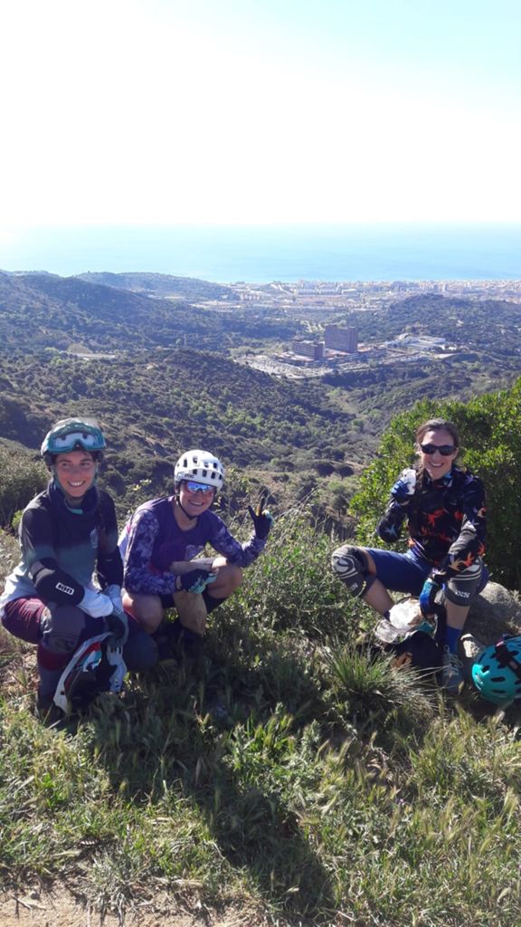
Badalona tiene flow _

MTB
MTB
Ref..: 669892
Published: 09/04/2019
Performed: 07/04/2019
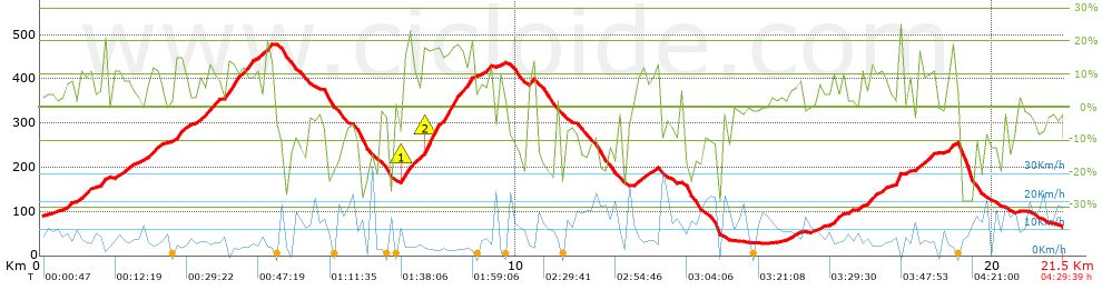
Distance in Km: 21.5
Climb in m: 967
IBP: 100 BYC

charlotte debarle
237 published routes

Add to my Group or Club

 Height in m      Climb in %      Speed in Km/h      Speed < 2 Km/h

Climbs > 5%

Climbs >5% Climbs >10% Climbs >15% Climbs >20% Climbs >25%
 Steep slope of 476 m.   Average slope  Distances  Download as waypoint
1
 Km 0.535  8%  476 m
 Steep slope of 159 m.  Average slope  Distances  Download as waypoint
2
 Km 1.264  13%  159 m
 Steep slope of 407 m.  Average slope  Distances  Download as waypoint
3
 Km 1.54  8%  407 m
 Steep slope of 474 m.  Average slope  Distances  Download as waypoint
4
 Km 2.075  7%  253 m
5
 Km 2.328  11%  114 m
6
 Km 2.441  9%  107 m
 Steep slope of 324 m.  Average slope  Distances  Download as waypoint
7
 Km 2.815  13%  242 m
8
 Km 3.057  7%  82 m
 Steep slope of 1132 m.  Average slope  Distances  Download as waypoint
9
 Km 3.259  8%  133 m
10
 Km 3.392  12%  241 m
11
 Km 3.634  8%  217 m
12
 Km 3.85  14%  403 m
13
 Km 4.253  13%  99 m
14
 Km 4.352  14%  39 m
 Steep slope of 353 m.  Average slope  Distances  Download as waypoint
15
 Km 4.513  7%  195 m
16
 Km 4.708  6%  39 m
17
 Km 4.747  16%  119 m
 Steep slope of 1542 m.  Average slope  Distances  Download as waypoint
18
 Km 7.575  9%  32 m
19
 Km 7.607  20%  153 m
20
 Km 7.759  10%  263 m
21
 Km 8.022  18%  758 m
22
 Km 8.781  13%  266 m
23
 Km 9.046  16%  70 m
 Steep slope of 264 m.  Average slope  Distances  Download as waypoint
24
 Km 9.229  8%  264 m
 Steep slope of 130 m.  Average slope  Distances  Download as waypoint
25
 Km 10.231  6%  37 m
26
 Km 10.268  14%  93 m
 Steep slope of 436 m.  Average slope  Distances  Download as waypoint
27
 Km 12.472  8%  436 m
 Steep slope of 184 m.  Average slope  Distances  Download as waypoint
28
 Km 15.769  7%  184 m
 Steep slope of 227 m.  Average slope  Distances  Download as waypoint
29
 Km 16.606  8%  62 m
30
 Km 16.668  11%  123 m
31
 Km 16.79  7%  42 m
 Steep slope of 349 m.  Average slope  Distances  Download as waypoint
32
 Km 17.195  7%  221 m
33
 Km 17.416  13%  128 m
 Steep slope of 210 m.  Average slope  Distances  Download as waypoint
34
 Km 17.649  8%  210 m
 Steep slope of 216 m.  Average slope  Distances  Download as waypoint
35
 Km 17.969  11%  216 m
 Steep slope of 362 m.  Average slope  Distances  Download as waypoint
36
 Km 18.405  10%  180 m
37
 Km 18.585  10%  116 m
38
 Km 18.7  12%  66 m
 Steep slope of 166 m.  Average slope  Distances  Download as waypoint
39
 Km 19.046  13%  166 m


Description of the route


Presence of ramps


 Climbs  Distance  % of the total  Speed  Your speed would be  Time  Your time would be
   15 - 30%  1.649  7.67  4.51  ?  0:21:57  ?
   10 - 15%  2.479  11.53  5.47  ?  0:27:11  ?
   5 - 10%  3.524  16.39  6.89  ?  0:30:41  ?
   1 - 5%  3.009  13.99  9.79  ?  0:18:27  ?
   Total*  10.661 Km  49.58 %  6.51 Km/h  ? Km/h    1:38:16 h  ? h  
 Flat
   1 - -1%  1.933 Km  8.99 %  10.69 Km/h  ? Km/h    0:10:51 h  ? h  
 Descents
   -1 - -5%  2.268  10.55  15.67  ?  0:08:41  ?
   -5 - -10%  2.104  9.78  13.67  ?  0:09:14  ?
   -10 - -15%  1.949  9.06  11.77  ?  0:09:56  ?
   -15 - -30%  2.59  12.04  10.77  ?  0:14:26  ?
   Total*  8.91 Km  41.43 %  12.64 Km/h  ? Km/h    0:42:17 h  ? h  
* The total has not necessarily coincide with the sum of the partials after correction of errors

How long would it take you?

How long would it take you to cover this route?
There are routes without a valid time information, but with your average stats you can assess the possible duration

charlotte debarle to cover this route you've need a time of:   2:31:24 h 
If you sign in and have a minimum of two tracks of this same modality, you can know your time for this route, calculated from your stats..


¿Cuanto consumirá tu E-BIKE?

Entra tu E-IBP (formato n,nn)

E-IBP :   X 100 = 


 Detected activity type =  ()
 Penalization due to track conditions: 52 %   ( > 50 % = MTB, < 50 % = RDB)
 Reliability of the track: A   (971/85/0/-/-/85)
 Correction level applied to the track: 0
DIFFICULTY OF THE ROUTE
IBP = 100 BYC
According to your statistics
 Your time in motion would be: ? h
Your average speed would be: ? Km/h
 

 Total Distance: 21.5 Km
 Analysed distance: 21.5 Km
 Linear distance: 0.06 Km

 Cumulated positive ramps: 967.45 m  list of points info
 Cumulated negative ramps: 989.64 m
 Maximum height: 478.8 m
 Minimum height: 28.2 m
 Climbing Ratio: 9.07 %
 Descent ratio: 11.11 %
 Cumulated postive ramps per Km: 45 m
 Cumulated negative ramps per Km: 46.03 m

 Total time: 4:29:39 h
 Time in movement: 2:31:24 h
 According to your statistics
 Your time in motion would be: ? h  
 Stopped time: 1:58:15 h
 Maximum slope filter: ~30 %
 Minimum separation analysed: ~30 m
 Number of points: 1405   (cad. 15.31 m)
 Significant waypoints: 563   (cad. 38.2 m / 40.07 %)

 Changes in direction per Km: 11.86
 Changes in direction > 5º por Km: 10.09
 Cumulated straight stretches: 2.319 Km
 Straight stretches per Km: 107.86 m
 Penalized slope changes: 9
 Penalized slope changes per Km: 0.419

 Average speed in total: 4.78 Km/h
 Average speed while moving: 8.52 Km/h
 According to your statistics
 Your average speed would be: ? Km/h  
 Maximum sustained speed: 34.5 Km/h


Comments

You can be the first one in commenting this route

 
My comments
:
Add comment  (Registered users)
 
Notify me answers to my comment  Do not notify answers to my comment


Share this route with a friend

Your friend will receive a message with a link to this page:
will see your email and your user name if you do it as registered user.


Write here your name (optional)

E-mail address of your friend(s). You can include various addresses separated by commas

Text or comment (optional) maximum 255 characters long, 255 Available characters

As a non registered users you need to fill-in the captcha text.
  Change image
Type the image characters.
 
 Share with a friend


Visited history

Delete history

Marked routes for review later or compare

My favorites


  Notify anomaly in this route Share in Facebook