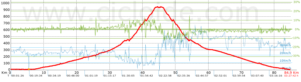
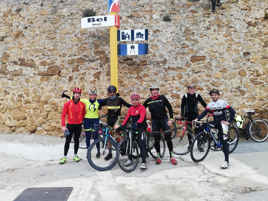
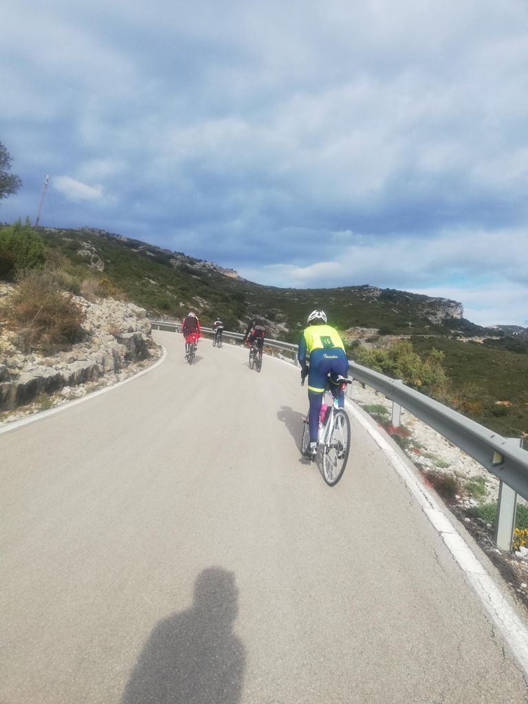
Crono escalada a...... Bel

Road
Road
Ref..: 665123
Published: 04/04/2019
Performed: 02/04/2019
Distance in Km: 84.9
Climb in m: 1084
IBP: 71 BYC


 Height in m      Climb in %      Speed in Km/h      Speed < 2 Km/h

Climbs > 5%

Climbs >5% Climbs >10% Climbs >15% Climbs >20% Climbs >25%
 Steep slope of 113 m.   Average slope  Distances  Download as waypoint
1
 Km 14.926  7%  113 m
 Steep slope of 150 m.  Average slope  Distances  Download as waypoint
2
 Km 25.777  10%  150 m
 Steep slope of 196 m.  Average slope  Distances  Download as waypoint
3
 Km 32.627  6%  196 m
 Steep slope of 250 m.  Average slope  Distances  Download as waypoint
4
 Km 33.313  6%  250 m
 Steep slope of 212 m.  Average slope  Distances  Download as waypoint
5
 Km 33.805  8%  212 m
 Steep slope of 202 m.  Average slope  Distances  Download as waypoint
6
 Km 34.254  7%  202 m
 Steep slope of 287 m.  Average slope  Distances  Download as waypoint
7
 Km 35.996  9%  287 m
 Steep slope of 230 m.  Average slope  Distances  Download as waypoint
8
 Km 36.551  5%  230 m
 Steep slope of 458 m.  Average slope  Distances  Download as waypoint
9
 Km 36.932  7%  458 m
 Steep slope of 181 m.  Average slope  Distances  Download as waypoint
10
 Km 37.499  6%  181 m
 Steep slope of 135 m.  Average slope  Distances  Download as waypoint
11
 Km 37.792  7%  135 m
 Steep slope of 653 m.  Average slope  Distances  Download as waypoint
12
 Km 38.04  8%  243 m
13
 Km 38.283  11%  137 m
14
 Km 38.421  7%  273 m
 Steep slope of 273 m.  Average slope  Distances  Download as waypoint
15
 Km 38.803  10%  35 m
16
 Km 38.838  11%  138 m
17
 Km 38.976  9%  100 m
 Steep slope of 335 m.  Average slope  Distances  Download as waypoint
18
 Km 39.178  8%  335 m
 Steep slope of 695 m.  Average slope  Distances  Download as waypoint
19
 Km 40.06  9%  499 m
20
 Km 40.559  13%  99 m
21
 Km 40.658  8%  97 m
 Steep slope of 997 m.  Average slope  Distances  Download as waypoint
22
 Km 41.154  7%  487 m
23
 Km 41.64  10%  99 m
24
 Km 41.739  8%  411 m
 Steep slope of 103 m.  Average slope  Distances  Download as waypoint
25
 Km 42.438  6%  103 m
 Steep slope of 1068 m.  Average slope  Distances  Download as waypoint
26
 Km 42.688  8%  1068 m
 Steep slope of 106 m.  Average slope  Distances  Download as waypoint
27
 Km 45.324  5%  106 m
 Steep slope of 212 m.  Average slope  Distances  Download as waypoint
28
 Km 49.086  8%  212 m
 Steep slope of 181 m.  Average slope  Distances  Download as waypoint
29
 Km 54.094  9%  181 m


Description of the route


Presence of ramps


 Climbs  Distance  % of the total  Speed  Your speed would be  Time  Your time would be
   15 - 30%  0  0  0  ?  0:00:00  ?
   10 - 15%  1.174  1.38  9.46  ?  0:07:27  ?
   5 - 10%  6.566  7.73  11.87  ?  0:33:11  ?
   1 - 5%  21.267  25.05  22.22  ?  0:57:26  ?
   Total*  29.008 Km  34.17 %  17.75 Km/h  ? Km/h    1:38:04 h  ? h  
 Flat
   1 - -1%  23.376 Km  27.53 %  27.47 Km/h  ? Km/h    0:51:04 h  ? h  
 Descents
   -1 - -5%  25.543  30.08  38.68  ?  0:39:37  ?
   -5 - -10%  5.784  6.81  38.49  ?  0:09:01  ?
   -10 - -15%  1.162  1.37  35.44  ?  0:01:58  ?
   -15 - -30%  0.03  0.04  36.49  ?  0:00:03  ?
   Total*  32.519 Km  38.3 %  38.52 Km/h  ? Km/h    0:50:39 h  ? h  
* The total has not necessarily coincide with the sum of the partials after correction of errors

How long would it take you?

How long would it take you to cover this route?
There are routes without a valid time information, but with your average stats you can assess the possible duration

Carlos_Batiste_(Viajes_Bici_Maestrat) to cover this route you've need a time of:   3:19:47 h 
If you sign in and have a minimum of two tracks of this same modality, you can know your time for this route, calculated from your stats..


¿Cuanto consumirá tu E-BIKE?

Entra tu E-IBP (formato n,nn)

E-IBP :   X 71 = 


 Detected activity type =  ()
 Penalization due to track conditions: 30 %   ( > 50 % = MTB, < 50 % = RDB)
 Reliability of the track: B   (1084/65/0/-/-/65)
 Correction level applied to the track: 0
DIFFICULTY OF THE ROUTE
IBP = 71 BYC
According to your statistics
 Your time in motion would be: ? h
Your average speed would be: ? Km/h
 

 Total Distance: 84.9 Km
 Analysed distance: 84.9 Km
 Linear distance: 7.97 Km

 Cumulated positive ramps: 1084.4 m  list of points info
 Cumulated negative ramps: 1103.2 m
 Maximum height: 947 m
 Minimum height: 3.6 m
 Climbing Ratio: 3.74 %
 Descent ratio: 3.39 %
 Cumulated postive ramps per Km: 12.77 m
 Cumulated negative ramps per Km: 12.99 m

 Total time: 3:27:42 h
 Time in movement: 3:19:47 h
 According to your statistics
 Your time in motion would be: ? h  
 Stopped time: 0:07:55 h
 Maximum slope filter: ~30 %
 Minimum separation analysed: ~30 m
 Number of points: 6433   (cad. 13.2 m)
 Significant waypoints: 2349   (cad. 36.14 m / 36.51 %)

 Changes in direction per Km: 8.2
 Changes in direction > 5º por Km: 3.05
 Cumulated straight stretches: 46.398 Km
 Straight stretches per Km: 546.5 m
 Penalized slope changes: 6
 Penalized slope changes per Km: 0.071

 Average speed in total: 24.53 Km/h
 Average speed while moving: 25.5 Km/h
 According to your statistics
 Your average speed would be: ? Km/h  
 Maximum sustained speed: 61.34 Km/h


Comments

You can be the first one in commenting this route

 
My comments
:
Add comment  (Registered users)
 
Notify me answers to my comment  Do not notify answers to my comment


Share this route with a friend

Your friend will receive a message with a link to this page:
will see your email and your user name if you do it as registered user.


Write here your name (optional)

E-mail address of your friend(s). You can include various addresses separated by commas

Text or comment (optional) maximum 255 characters long, 255 Available characters

As a non registered users you need to fill-in the captcha text.
  Change image
Type the image characters.
 
 Share with a friend


Visited history

Delete history

Marked routes for review later or compare

My favorites


  Notify anomaly in this route Share in Facebook