Castelldefels Panta de Foix btt

MTB
MTB
Ref..: 662342
Published: 01/04/2019
Performed: 31/03/2019
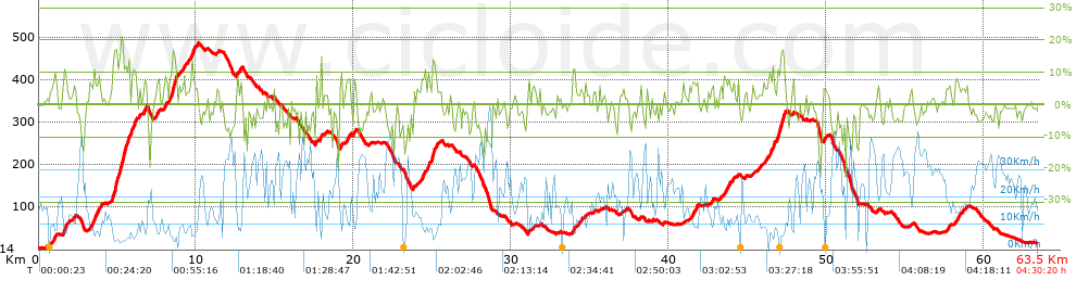
Distance in Km: 63.54
Climb in m: 1364
IBP: 102 BYC

Near ...
Bera (Urbanitzacio), Can Valls-To (Urbanitzacio), Casalot, El (Urbanitzacio), Castelldefels, Clara Mar (Urbanitzacio), Costa Zefir (Urbanitzacio)

 Height in m      Climb in %      Speed in Km/h      Speed < 2 Km/h

Climbs > 5%

Climbs >5% Climbs >10% Climbs >15% Climbs >20% Climbs >25%
 Steep slope of 223 m.   Average slope  Distances  Download as waypoint
1
 Km 0.931  8%  223 m
 Steep slope of 264 m.  Average slope  Distances  Download as waypoint
2
 Km 1.579  11%  119 m
3
 Km 1.698  8%  145 m
 Steep slope of 466 m.  Average slope  Distances  Download as waypoint
4
 Km 3.247  6%  253 m
5
 Km 3.5  10%  101 m
6
 Km 3.601  9%  112 m
 Steep slope of 154 m.  Average slope  Distances  Download as waypoint
7
 Km 3.81  8%  154 m
 Steep slope of 1555 m.  Average slope  Distances  Download as waypoint
8
 Km 4.675  13%  137 m
9
 Km 4.812  15%  168 m
10
 Km 4.981  12%  264 m
11
 Km 5.245  17%  230 m
12
 Km 5.474  11%  163 m
13
 Km 5.637  10%  230 m
14
 Km 5.867  10%  176 m
15
 Km 6.043  8%  104 m
16
 Km 6.147  11%  83 m
 Steep slope of 115 m.  Average slope  Distances  Download as waypoint
17
 Km 6.385  7%  115 m
 Steep slope of 215 m.  Average slope  Distances  Download as waypoint
18
 Km 6.653  7%  215 m
 Steep slope of 199 m.  Average slope  Distances  Download as waypoint
19
 Km 7.507  8%  199 m
 Steep slope of 175 m.  Average slope  Distances  Download as waypoint
20
 Km 7.987  8%  175 m
 Steep slope of 592 m.  Average slope  Distances  Download as waypoint
21
 Km 8.344  8%  31 m
22
 Km 8.375  13%  332 m
23
 Km 8.707  6%  229 m
 Steep slope of 111 m.  Average slope  Distances  Download as waypoint
24
 Km 9.235  9%  111 m
 Steep slope of 114 m.  Average slope  Distances  Download as waypoint
25
 Km 9.456  6%  114 m
 Steep slope of 364 m.  Average slope  Distances  Download as waypoint
26
 Km 9.69  11%  100 m
27
 Km 9.791  7%  264 m
 Steep slope of 248 m.  Average slope  Distances  Download as waypoint
28
 Km 12.583  7%  248 m
 Steep slope of 113 m.  Average slope  Distances  Download as waypoint
29
 Km 17.883  13%  113 m
 Steep slope of 152 m.  Average slope  Distances  Download as waypoint
30
 Km 19.158  8%  152 m
 Steep slope of 266 m.  Average slope  Distances  Download as waypoint
31
 Km 19.515  8%  266 m
 Steep slope of 194 m.  Average slope  Distances  Download as waypoint
32
 Km 19.974  8%  194 m
 Steep slope of 505 m.  Average slope  Distances  Download as waypoint
33
 Km 24.333  8%  505 m
 Steep slope of 380 m.  Average slope  Distances  Download as waypoint
34
 Km 24.956  9%  36 m
35
 Km 24.992  13%  185 m
36
 Km 25.177  7%  159 m
 Steep slope of 119 m.  Average slope  Distances  Download as waypoint
37
 Km 33.934  11%  119 m
 Steep slope of 216 m.  Average slope  Distances  Download as waypoint
38
 Km 34.252  5%  216 m
 Steep slope of 116 m.  Average slope  Distances  Download as waypoint
39
 Km 34.708  6%  116 m
 Steep slope of 470 m.  Average slope  Distances  Download as waypoint
40
 Km 41.331  6%  470 m
 Steep slope of 117 m.  Average slope  Distances  Download as waypoint
41
 Km 42.685  5%  117 m
 Steep slope of 361 m.  Average slope  Distances  Download as waypoint
42
 Km 43.538  8%  361 m
 Steep slope of 128 m.  Average slope  Distances  Download as waypoint
43
 Km 44.099  6%  128 m
 Steep slope of 347 m.  Average slope  Distances  Download as waypoint
44
 Km 46.422  7%  69 m
45
 Km 46.49  10%  167 m
46
 Km 46.657  10%  111 m
 Steep slope of 593 m.  Average slope  Distances  Download as waypoint
47
 Km 46.867  10%  108 m
48
 Km 46.975  11%  136 m
49
 Km 47.111  11%  39 m
50
 Km 47.149  16%  122 m
51
 Km 47.272  12%  155 m
52
 Km 47.427  5%  33 m
 Steep slope of 108 m.  Average slope  Distances  Download as waypoint
53
 Km 49.862  7%  108 m
 Steep slope of 205 m.  Average slope  Distances  Download as waypoint
54
 Km 57.641  5%  205 m
 Steep slope of 277 m.  Average slope  Distances  Download as waypoint
55
 Km 58.238  7%  277 m


Description of the route


Presence of ramps


 Climbs  Distance  % of the total  Speed  Your speed would be  Time  Your time would be
   15 - 30%  0.757  1.19  5.64  ?  0:08:03  ?
   10 - 15%  2.63  4.14  6.65  ?  0:23:43  ?
   5 - 10%  7.539  11.86  9.83  ?  0:46:01  ?
   1 - 5%  13.941  21.94  12.99  ?  1:04:23  ?
   Total*  24.867 Km  39.13 %  10.49 Km/h  ? Km/h    2:22:10 h  ? h  
 Flat
   1 - -1%  12.591 Km  19.82 %  20.33 Km/h  ? Km/h    0:37:10 h  ? h  
 Descents
   -1 - -5%  15.021  23.64  24.54  ?  0:36:44  ?
   -5 - -10%  8.656  13.62  29.18  ?  0:17:48  ?
   -10 - -15%  1.822  2.87  25.13  ?  0:04:21  ?
   -15 - -30%  0.587  0.92  13.98  ?  0:02:31  ?
   Total*  26.085 Km  41.05 %  25.49 Km/h  ? Km/h    1:01:24 h  ? h  
* The total has not necessarily coincide with the sum of the partials after correction of errors

How long would it take you?

How long would it take you to cover this route?
There are routes without a valid time information, but with your average stats you can assess the possible duration

Pau_"Polvorilla" to cover this route you've need a time of:   4:00:44 h 
If you sign in and have a minimum of two tracks of this same modality, you can know your time for this route, calculated from your stats..


¿Cuanto consumirá tu E-BIKE?

Entra tu E-IBP (formato n,nn)

E-IBP :   X 102 = 


 Detected activity type =  ()
 Penalization due to track conditions: 64 %   ( > 50 % = MTB, < 50 % = RDB)
 Reliability of the track: B   (1363/70/0/-/-/70)
 Correction level applied to the track: 0
DIFFICULTY OF THE ROUTE
IBP = 102 BYC
According to your statistics
 Your time in motion would be: ? h
Your average speed would be: ? Km/h
 

 Total Distance: 63.54 Km
 Analysed distance: 63.54 Km
 Linear distance: 21.41 Km

 Cumulated positive ramps: 1363.8 m  list of points info
 Cumulated negative ramps: 1344.2 m
 Maximum height: 486.6 m
 Minimum height: 3 m
 Climbing Ratio: 5.48 %
 Descent ratio: 5.15 %
 Cumulated postive ramps per Km: 21.46 m
 Cumulated negative ramps per Km: 21.16 m

 Total time: 4:30:20 h
 Time in movement: 4:00:44 h
 According to your statistics
 Your time in motion would be: ? h  
 Stopped time: 0:29:36 h
 Maximum slope filter: ~30 %
 Minimum separation analysed: ~30 m
 Number of points: 2926   (cad. 21.72 m)
 Significant waypoints: 1478   (cad. 42.99 m / 50.51 %)

 Changes in direction per Km: 9.07
 Changes in direction > 5º por Km: 6.61
 Cumulated straight stretches: 12.627 Km
 Straight stretches per Km: 198.73 m
 Penalized slope changes: 13
 Penalized slope changes per Km: 0.205

 Average speed in total: 14.1 Km/h
 Average speed while moving: 15.84 Km/h
 According to your statistics
 Your average speed would be: ? Km/h  
 Maximum sustained speed: 55.5 Km/h


Comments

You can be the first one in commenting this route

 
My comments
:
Add comment  (Registered users)
 
Notify me answers to my comment  Do not notify answers to my comment


Share this route with a friend

Your friend will receive a message with a link to this page:
will see your email and your user name if you do it as registered user.


Write here your name (optional)

E-mail address of your friend(s). You can include various addresses separated by commas

Text or comment (optional) maximum 255 characters long, 255 Available characters

As a non registered users you need to fill-in the captcha text.
  Change image
Type the image characters.
 
 Share with a friend


Visited history

Delete history

Marked routes for review later or compare

My favorites


  Notify anomaly in this route Share in Facebook