J ai beau être matinale, j'ai mal...

Road
Road
Ref..: 652760
Published: 24/03/2019
Performed: 24/03/2019
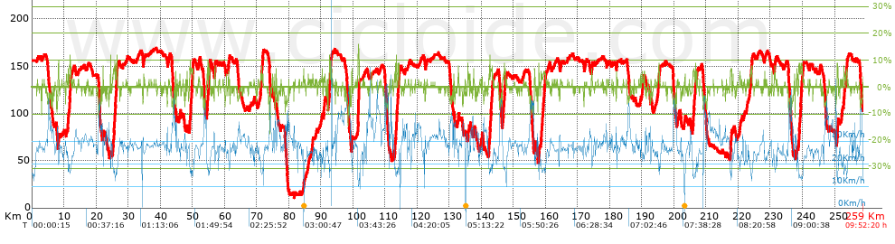
Distance in Km: 258.97
Climb in m: 2289
IBP: 238 BYC

Bixente_Hacala
61 published routes

Add to my Group or Club

 Height in m      Climb in %      Speed in Km/h      Speed < 2 Km/h

Climbs > 5%

Climbs >5% Climbs >10% Climbs >15% Climbs >20% Climbs >25%
 Steep slope of 117 m.   Average slope  Distances  Download as waypoint
1
 Km 8.219  5%  117 m
 Steep slope of 166 m.  Average slope  Distances  Download as waypoint
2
 Km 11.251  7%  166 m
 Steep slope of 222 m.  Average slope  Distances  Download as waypoint
3
 Km 11.653  6%  222 m
 Steep slope of 209 m.  Average slope  Distances  Download as waypoint
4
 Km 12.011  7%  209 m
 Steep slope of 131 m.  Average slope  Distances  Download as waypoint
5
 Km 22.17  7%  131 m
 Steep slope of 111 m.  Average slope  Distances  Download as waypoint
6
 Km 25.304  5%  111 m
 Steep slope of 518 m.  Average slope  Distances  Download as waypoint
7
 Km 25.514  7%  518 m
 Steep slope of 161 m.  Average slope  Distances  Download as waypoint
8
 Km 26.139  6%  161 m
 Steep slope of 248 m.  Average slope  Distances  Download as waypoint
9
 Km 26.398  9%  248 m
 Steep slope of 152 m.  Average slope  Distances  Download as waypoint
10
 Km 49.147  6%  152 m
 Steep slope of 483 m.  Average slope  Distances  Download as waypoint
11
 Km 49.454  6%  483 m
 Steep slope of 229 m.  Average slope  Distances  Download as waypoint
12
 Km 50.04  7%  229 m
 Steep slope of 154 m.  Average slope  Distances  Download as waypoint
13
 Km 54.493  6%  154 m
 Steep slope of 194 m.  Average slope  Distances  Download as waypoint
14
 Km 54.761  6%  194 m
 Steep slope of 353 m.  Average slope  Distances  Download as waypoint
15
 Km 55.121  7%  353 m
 Steep slope of 183 m.  Average slope  Distances  Download as waypoint
16
 Km 56.918  5%  183 m
 Steep slope of 200 m.  Average slope  Distances  Download as waypoint
17
 Km 71.313  6%  200 m
 Steep slope of 261 m.  Average slope  Distances  Download as waypoint
18
 Km 71.622  5%  261 m
 Steep slope of 116 m.  Average slope  Distances  Download as waypoint
19
 Km 91.015  5%  116 m
 Steep slope of 408 m.  Average slope  Distances  Download as waypoint
20
 Km 92.562  7%  408 m
 Steep slope of 127 m.  Average slope  Distances  Download as waypoint
21
 Km 93.078  7%  127 m
 Steep slope of 210 m.  Average slope  Distances  Download as waypoint
22
 Km 99.579  6%  210 m
 Steep slope of 430 m.  Average slope  Distances  Download as waypoint
23
 Km 101.533  9%  125 m
24
 Km 101.658  15%  115 m
25
 Km 101.774  13%  151 m
26
 Km 101.925  8%  39 m
 Steep slope of 111 m.  Average slope  Distances  Download as waypoint
27
 Km 112.952  5%  111 m
 Steep slope of 105 m.  Average slope  Distances  Download as waypoint
28
 Km 113.177  6%  105 m
 Steep slope of 421 m.  Average slope  Distances  Download as waypoint
29
 Km 113.519  12%  127 m
30
 Km 113.645  5%  111 m
31
 Km 113.756  7%  183 m
 Steep slope of 335 m.  Average slope  Distances  Download as waypoint
32
 Km 114.033  7%  335 m
 Steep slope of 110 m.  Average slope  Distances  Download as waypoint
33
 Km 132.783  7%  110 m
 Steep slope of 112 m.  Average slope  Distances  Download as waypoint
34
 Km 142.29  6%  112 m
 Steep slope of 163 m.  Average slope  Distances  Download as waypoint
35
 Km 142.579  8%  163 m
 Steep slope of 515 m.  Average slope  Distances  Download as waypoint
36
 Km 142.844  7%  515 m
 Steep slope of 102 m.  Average slope  Distances  Download as waypoint
37
 Km 143.47  6%  102 m
 Steep slope of 115 m.  Average slope  Distances  Download as waypoint
38
 Km 146.767  5%  115 m
 Steep slope of 429 m.  Average slope  Distances  Download as waypoint
39
 Km 146.981  6%  429 m
 Steep slope of 119 m.  Average slope  Distances  Download as waypoint
40
 Km 156.511  7%  119 m
 Steep slope of 216 m.  Average slope  Distances  Download as waypoint
41
 Km 158.994  5%  216 m
 Steep slope of 151 m.  Average slope  Distances  Download as waypoint
42
 Km 159.351  5%  151 m
 Steep slope of 281 m.  Average slope  Distances  Download as waypoint
43
 Km 159.649  5%  281 m
 Steep slope of 111 m.  Average slope  Distances  Download as waypoint
44
 Km 194.989  5%  111 m
 Steep slope of 199 m.  Average slope  Distances  Download as waypoint
45
 Km 205.845  5%  199 m
 Steep slope of 265 m.  Average slope  Distances  Download as waypoint
46
 Km 206.146  7%  265 m
 Steep slope of 116 m.  Average slope  Distances  Download as waypoint
47
 Km 207.057  6%  116 m
 Steep slope of 362 m.  Average slope  Distances  Download as waypoint
48
 Km 217.532  6%  362 m
 Steep slope of 218 m.  Average slope  Distances  Download as waypoint
49
 Km 223.787  6%  218 m
 Steep slope of 152 m.  Average slope  Distances  Download as waypoint
50
 Km 224.107  7%  152 m
 Steep slope of 408 m.  Average slope  Distances  Download as waypoint
51
 Km 238.843  6%  408 m
 Steep slope of 237 m.  Average slope  Distances  Download as waypoint
52
 Km 239.375  7%  237 m
 Steep slope of 246 m.  Average slope  Distances  Download as waypoint
53
 Km 239.802  6%  246 m
 Steep slope of 393 m.  Average slope  Distances  Download as waypoint
54
 Km 250.711  7%  393 m
 Steep slope of 108 m.  Average slope  Distances  Download as waypoint
55
 Km 252.764  6%  108 m
 Steep slope of 272 m.  Average slope  Distances  Download as waypoint
56
 Km 253.504  6%  272 m


Description of the route


Presence of ramps


 Climbs  Distance  % of the total  Speed  Your speed would be  Time  Your time would be
   15 - 30%  0.111  0.04  11.09  ?  0:00:36  ?
   10 - 15%  1.038  0.4  16.11  ?  0:03:52  ?
   5 - 10%  14.49  5.6  18.56  ?  0:46:51  ?
   1 - 5%  41.409  15.99  24.21  ?  1:42:37  ?
   Total*  57.048 Km  22.03 %  22.24 Km/h  ? Km/h    2:33:56 h  ? h  
 Flat
   1 - -1%  141.702 Km  54.72 %  28.54 Km/h  ? Km/h    4:57:51 h  ? h  
 Descents
   -1 - -5%  44.708  17.26  32.57  ?  1:22:22  ?
   -5 - -10%  14.779  5.71  37.08  ?  0:23:55  ?
   -10 - -15%  0.682  0.26  43.08  ?  0:00:57  ?
   -15 - -30%  0.054  0.02  48.9  ?  0:00:04  ?
   Total*  60.223 Km  23.25 %  33.68 Km/h  ? Km/h    1:47:18 h  ? h  
* The total has not necessarily coincide with the sum of the partials after correction of errors

How long would it take you?

How long would it take you to cover this route?
There are routes without a valid time information, but with your average stats you can assess the possible duration

Bixente_Hacala to cover this route you've need a time of:   9:19:05 h 
If you sign in and have a minimum of two tracks of this same modality, you can know your time for this route, calculated from your stats..


¿Cuanto consumirá tu E-BIKE?

Entra tu E-IBP (formato n,nn)

E-IBP :   X 238 = 


 Detected activity type =  ()
 Penalization due to track conditions: 32 %   ( > 50 % = MTB, < 50 % = RDB)
 Reliability of the track: A   (2289/74/0/-/-/74)
 Correction level applied to the track: 0
DIFFICULTY OF THE ROUTE
IBP = 238 BYC
According to your statistics
 Your time in motion would be: ? h
Your average speed would be: ? Km/h
 

 Total Distance: 258.97 Km
 Analysed distance: 258.97 Km
 Linear distance: 0.16 Km

 Cumulated positive ramps: 2289 m  list of points info
 Cumulated negative ramps: 2340 m
 Maximum height: 169.1 m
 Minimum height: 11.1 m
 Climbing Ratio: 4.01 %
 Descent ratio: 3.89 %
 Cumulated postive ramps per Km: 8.84 m
 Cumulated negative ramps per Km: 9.04 m

 Total time: 9:52:20 h
 Time in movement: 9:19:05 h
 According to your statistics
 Your time in motion would be: ? h  
 Stopped time: 0:33:15 h
 Maximum slope filter: ~30 %
 Minimum separation analysed: ~30 m
 Number of points: 14589   (cad. 17.75 m)
 Significant waypoints: 6805   (cad. 38.06 m / 46.64 %)

 Changes in direction per Km: 10.01
 Changes in direction > 5º por Km: 2.69
 Cumulated straight stretches: 136.156 Km
 Straight stretches per Km: 525.76 m
 Penalized slope changes: 33
 Penalized slope changes per Km: 0.127

 Average speed in total: 26.23 Km/h
 Average speed while moving: 27.79 Km/h
 According to your statistics
 Your average speed would be: ? Km/h  
 Maximum sustained speed: 57.88 Km/h


Comments

You can be the first one in commenting this route

 
My comments
:
Add comment  (Registered users)
 
Notify me answers to my comment  Do not notify answers to my comment


Share this route with a friend

Your friend will receive a message with a link to this page:
will see your email and your user name if you do it as registered user.


Write here your name (optional)

E-mail address of your friend(s). You can include various addresses separated by commas

Text or comment (optional) maximum 255 characters long, 255 Available characters

As a non registered users you need to fill-in the captcha text.
  Change image
Type the image characters.
 
 Share with a friend


Visited history

Delete history

Marked routes for review later or compare

My favorites


  Notify anomaly in this route Share in Facebook