Peares A Barrela Cea

Road
Road
Ref..: 650177
Published: 22/03/2019
Performed: 20/03/2019
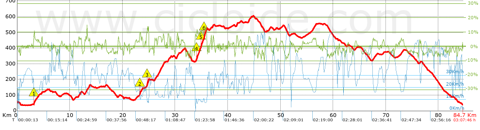
Distance in Km: 84.7
Climb in m: 1348
IBP: 83 BYC

Near ...
Arnoia, A (San Salvador), Aspera (San Cibrao Das Viñas), Astres, Barreiros Zona Comercial, Beiro (Ourense), Bemposta (Ourense)
Antonio Soto Domonte
388 published routes

Add to my Group or Club

 Height in m      Climb in %      Speed in Km/h      Speed < 2 Km/h

Climbs > 5%

Climbs >5% Climbs >10% Climbs >15% Climbs >20% Climbs >25%
 Steep slope of 484 m.   Average slope  Distances  Download as waypoint
1
 Km 3.131  7%  29 m
2
 Km 3.161  11%  117 m
3
 Km 3.278  6%  338 m
 Steep slope of 119 m.  Average slope  Distances  Download as waypoint
4
 Km 3.739  5%  119 m
 Steep slope of 133 m.  Average slope  Distances  Download as waypoint
5
 Km 3.972  5%  133 m
 Steep slope of 120 m.  Average slope  Distances  Download as waypoint
6
 Km 4.621  5%  120 m
 Steep slope of 261 m.  Average slope  Distances  Download as waypoint
7
 Km 11.667  5%  261 m
 Steep slope of 128 m.  Average slope  Distances  Download as waypoint
8
 Km 12.032  6%  128 m
 Steep slope of 307 m.  Average slope  Distances  Download as waypoint
9
 Km 12.88  6%  307 m
 Steep slope of 408 m.  Average slope  Distances  Download as waypoint
10
 Km 13.299  6%  408 m
 Steep slope of 366 m.  Average slope  Distances  Download as waypoint
11
 Km 23.244  8%  36 m
12
 Km 23.28  11%  119 m
13
 Km 23.398  7%  211 m
 Steep slope of 110 m.  Average slope  Distances  Download as waypoint
14
 Km 23.72  7%  110 m
 Steep slope of 468 m.  Average slope  Distances  Download as waypoint
15
 Km 24.544  7%  82 m
16
 Km 24.627  13%  343 m
17
 Km 24.97  10%  43 m
 Steep slope of 187 m.  Average slope  Distances  Download as waypoint
18
 Km 26.104  6%  187 m
 Steep slope of 113 m.  Average slope  Distances  Download as waypoint
19
 Km 26.399  5%  113 m
 Steep slope of 1236 m.  Average slope  Distances  Download as waypoint
20
 Km 26.656  7%  1236 m
 Steep slope of 291 m.  Average slope  Distances  Download as waypoint
21
 Km 28.6  7%  291 m
 Steep slope of 116 m.  Average slope  Distances  Download as waypoint
22
 Km 29.094  8%  116 m
 Steep slope of 417 m.  Average slope  Distances  Download as waypoint
23
 Km 30.252  7%  417 m
 Steep slope of 114 m.  Average slope  Distances  Download as waypoint
24
 Km 31.141  5%  114 m
 Steep slope of 2129 m.  Average slope  Distances  Download as waypoint
25
 Km 33.827  7%  233 m
26
 Km 34.06  11%  177 m
27
 Km 34.237  9%  659 m
28
 Km 34.897  11%  357 m
29
 Km 35.254  7%  204 m
30
 Km 35.458  12%  499 m
 Steep slope of 150 m.  Average slope  Distances  Download as waypoint
31
 Km 36.753  7%  150 m
 Steep slope of 122 m.  Average slope  Distances  Download as waypoint
32
 Km 37.09  5%  122 m
 Steep slope of 247 m.  Average slope  Distances  Download as waypoint
33
 Km 41.619  7%  247 m
 Steep slope of 251 m.  Average slope  Distances  Download as waypoint
34
 Km 43.934  7%  251 m
 Steep slope of 162 m.  Average slope  Distances  Download as waypoint
35
 Km 47.825  5%  162 m
 Steep slope of 596 m.  Average slope  Distances  Download as waypoint
36
 Km 56.067  6%  596 m
 Steep slope of 142 m.  Average slope  Distances  Download as waypoint
37
 Km 67.476  5%  142 m
 Steep slope of 114 m.  Average slope  Distances  Download as waypoint
38
 Km 72.82  5%  114 m
 Steep slope of 172 m.  Average slope  Distances  Download as waypoint
39
 Km 73.089  5%  172 m


Description of the route


Presence of ramps


 Climbs  Distance  % of the total  Speed  Your speed would be  Time  Your time would be
   15 - 30%  0.029  0.03  7.53  ?  0:00:14  ?
   10 - 15%  1.766  2.08  9.93  ?  0:10:40  ?
   5 - 10%  8.335  9.84  15.5  ?  0:32:16  ?
   1 - 5%  21.107  24.92  23.55  ?  0:53:46  ?
   Total*  31.236 Km  36.88 %  19.33 Km/h  ? Km/h    1:36:56 h  ? h  
 Flat
   1 - -1%  16.248 Km  19.18 %  30.04 Km/h  ? Km/h    0:32:27 h  ? h  
 Descents
   -1 - -5%  29.371  34.68  38.79  ?  0:45:26  ?
   -5 - -10%  7.603  8.98  43.65  ?  0:10:27  ?
   -10 - -15%  0.242  0.29  15.26  ?  0:00:57  ?
   -15 - -30%  0  0  0  ?  0:00:00  ?
   Total*  37.215 Km  43.94 %  39.29 Km/h  ? Km/h    0:56:50 h  ? h  
* The total has not necessarily coincide with the sum of the partials after correction of errors

How long would it take you?

How long would it take you to cover this route?
There are routes without a valid time information, but with your average stats you can assess the possible duration

Antonio Soto Domonte to cover this route you've need a time of:   3:06:13 h 
If you sign in and have a minimum of two tracks of this same modality, you can know your time for this route, calculated from your stats..


¿Cuanto consumirá tu E-BIKE?

Entra tu E-IBP (formato n,nn)

E-IBP :   X 83 = 


 Detected activity type =  ()
 Penalization due to track conditions: 33 %   ( > 50 % = MTB, < 50 % = RDB)
 Reliability of the track: A   (1352/74/0/-/-/74)
 Correction level applied to the track: 0
DIFFICULTY OF THE ROUTE
IBP = 83 BYC
According to your statistics
 Your time in motion would be: ? h
Your average speed would be: ? Km/h
 

 Total Distance: 84.7 Km
 Analysed distance: 84.7 Km
 Linear distance: 0.68 Km

 Cumulated positive ramps: 1348.04 m  list of points info
 Cumulated negative ramps: 1369.24 m
 Maximum height: 605.6 m
 Minimum height: 34.6 m
 Climbing Ratio: 4.32 %
 Descent ratio: 3.68 %
 Cumulated postive ramps per Km: 15.92 m
 Cumulated negative ramps per Km: 16.17 m

 Total time: 3:07:46 h
 Time in movement: 3:06:13 h
 According to your statistics
 Your time in motion would be: ? h  
 Stopped time: 0:01:33 h
 Maximum slope filter: ~30 %
 Minimum separation analysed: ~30 m
 Number of points: 3449   (cad. 24.56 m)
 Significant waypoints: 1916   (cad. 44.21 m / 55.55 %)

 Changes in direction per Km: 7.36
 Changes in direction > 5º por Km: 3.44
 Cumulated straight stretches: 38.392 Km
 Straight stretches per Km: 453.27 m
 Penalized slope changes: 15
 Penalized slope changes per Km: 0.177

 Average speed in total: 27.07 Km/h
 Average speed while moving: 27.29 Km/h
 According to your statistics
 Your average speed would be: ? Km/h  
 Maximum sustained speed: 74.37 Km/h


Comments

You can be the first one in commenting this route

 
My comments
:
Add comment  (Registered users)
 
Notify me answers to my comment  Do not notify answers to my comment


Share this route with a friend

Your friend will receive a message with a link to this page:
will see your email and your user name if you do it as registered user.


Write here your name (optional)

E-mail address of your friend(s). You can include various addresses separated by commas

Text or comment (optional) maximum 255 characters long, 255 Available characters

As a non registered users you need to fill-in the captcha text.
  Change image
Type the image characters.
 
 Share with a friend


Visited history

Delete history

Marked routes for review later or compare

My favorites


  Notify anomaly in this route Share in Facebook