Mogoda (Barcelona)

Road
Road
Ref..: 625468
Published: 24/02/2019
Performed: 24/02/2019
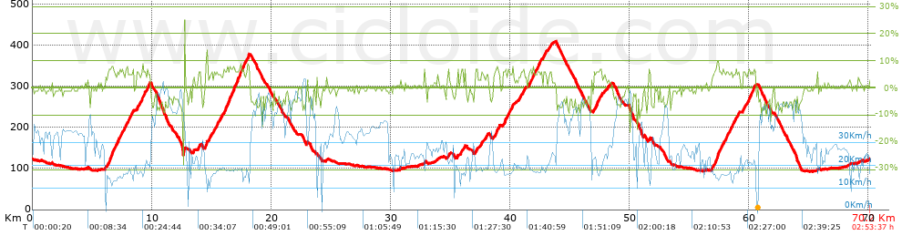
Distance in Km: 70.19
Climb in m: 1184
IBP: 73 BYC

Near ...
Florida, La, Llagosta, La, Mogoda, Ripollet, Santa Perpetua De Mogoda, Santiga (Santa Perpetua De Mogoda)

 Height in m      Climb in %      Speed in Km/h      Speed < 2 Km/h

Climbs > 5%

Climbs >5% Climbs >10% Climbs >15% Climbs >20% Climbs >25%
 Steep slope of 1716 m.   Average slope  Distances  Download as waypoint
1
 Km 6.336  6%  1716 m
 Steep slope of 250 m.  Average slope  Distances  Download as waypoint
2
 Km 8.179  6%  250 m
 Steep slope of 176 m.  Average slope  Distances  Download as waypoint
3
 Km 8.745  7%  176 m
 Steep slope of 495 m.  Average slope  Distances  Download as waypoint
4
 Km 9.161  6%  495 m
 Steep slope of 113 m.  Average slope  Distances  Download as waypoint
5
 Km 13.947  7%  113 m
 Steep slope of 219 m.  Average slope  Distances  Download as waypoint
6
 Km 14.5  7%  219 m
 Steep slope of 419 m.  Average slope  Distances  Download as waypoint
7
 Km 15.196  6%  419 m
 Steep slope of 1661 m.  Average slope  Distances  Download as waypoint
8
 Km 16.016  7%  1661 m
 Steep slope of 325 m.  Average slope  Distances  Download as waypoint
9
 Km 17.782  6%  325 m
 Steep slope of 179 m.  Average slope  Distances  Download as waypoint
10
 Km 35.906  7%  179 m
 Steep slope of 138 m.  Average slope  Distances  Download as waypoint
11
 Km 37.108  6%  138 m
 Steep slope of 130 m.  Average slope  Distances  Download as waypoint
12
 Km 37.598  6%  130 m
 Steep slope of 109 m.  Average slope  Distances  Download as waypoint
13
 Km 37.995  7%  109 m
 Steep slope of 328 m.  Average slope  Distances  Download as waypoint
14
 Km 38.724  6%  328 m
 Steep slope of 498 m.  Average slope  Distances  Download as waypoint
15
 Km 39.439  6%  498 m
 Steep slope of 207 m.  Average slope  Distances  Download as waypoint
16
 Km 40.033  6%  207 m
 Steep slope of 189 m.  Average slope  Distances  Download as waypoint
17
 Km 40.939  6%  189 m
 Steep slope of 967 m.  Average slope  Distances  Download as waypoint
18
 Km 41.621  6%  967 m
 Steep slope of 234 m.  Average slope  Distances  Download as waypoint
19
 Km 42.804  7%  234 m
 Steep slope of 175 m.  Average slope  Distances  Download as waypoint
20
 Km 43.182  5%  175 m
 Steep slope of 393 m.  Average slope  Distances  Download as waypoint
21
 Km 46.998  6%  393 m
 Steep slope of 112 m.  Average slope  Distances  Download as waypoint
22
 Km 47.505  6%  112 m
 Steep slope of 1043 m.  Average slope  Distances  Download as waypoint
23
 Km 57.043  6%  1043 m
 Steep slope of 533 m.  Average slope  Distances  Download as waypoint
24
 Km 58.21  6%  533 m
 Steep slope of 321 m.  Average slope  Distances  Download as waypoint
25
 Km 58.9  6%  321 m
 Steep slope of 223 m.  Average slope  Distances  Download as waypoint
26
 Km 59.49  6%  223 m
 Steep slope of 492 m.  Average slope  Distances  Download as waypoint
27
 Km 59.904  6%  492 m


Description of the route


Presence of ramps


 Climbs  Distance  % of the total  Speed  Your speed would be  Time  Your time would be
   15 - 30%  0.064  0.09  38.12  ?  0:00:06  ?
   10 - 15%  0.206  0.29  12.59  ?  0:00:59  ?
   5 - 10%  12.521  17.84  18.15  ?  0:41:23  ?
   1 - 5%  11.144  15.88  19.64  ?  0:34:03  ?
   Total*  23.935 Km  34.1 %  18.77 Km/h  ? Km/h    1:16:31 h  ? h  
 Flat
   1 - -1%  21.902 Km  31.2 %  27.47 Km/h  ? Km/h    0:47:50 h  ? h  
 Descents
   -1 - -5%  13.271  18.91  32.65  ?  0:24:23  ?
   -5 - -10%  10.447  14.88  41.6  ?  0:15:04  ?
   -10 - -15%  0.445  0.63  37.25  ?  0:00:43  ?
   -15 - -30%  0.189  0.27  26.19  ?  0:00:26  ?
   Total*  24.352 Km  34.69 %  35.99 Km/h  ? Km/h    0:40:36 h  ? h  
* The total has not necessarily coincide with the sum of the partials after correction of errors

How long would it take you?

How long would it take you to cover this route?
There are routes without a valid time information, but with your average stats you can assess the possible duration

Jose_Manuel_Blanco_Ardila to cover this route you've need a time of:   2:44:57 h 
If you sign in and have a minimum of two tracks of this same modality, you can know your time for this route, calculated from your stats..


¿Cuanto consumirá tu E-BIKE?

Entra tu E-IBP (formato n,nn)

E-IBP :   X 73 = 


 Detected activity type =  ()
 Penalization due to track conditions: 46 %   ( > 50 % = MTB, < 50 % = RDB)
 Reliability of the track: A   (1198/79/0/-/-/79)
 Correction level applied to the track: 0
DIFFICULTY OF THE ROUTE
IBP = 73 BYC
According to your statistics
 Your time in motion would be: ? h
Your average speed would be: ? Km/h
 

 Total Distance: 70.19 Km
 Analysed distance: 70.19 Km
 Linear distance: 0.04 Km

 Cumulated positive ramps: 1184.07 m  list of points info
 Cumulated negative ramps: 1175.47 m
 Maximum height: 410 m
 Minimum height: 92.6 m
 Climbing Ratio: 4.95 %
 Descent ratio: 4.83 %
 Cumulated postive ramps per Km: 16.87 m
 Cumulated negative ramps per Km: 16.75 m

 Total time: 2:53:37 h
 Time in movement: 2:44:57 h
 According to your statistics
 Your time in motion would be: ? h  
 Stopped time: 0:08:40 h
 Maximum slope filter: ~30 %
 Minimum separation analysed: ~30 m
 Number of points: 2704   (cad. 25.96 m)
 Significant waypoints: 1521   (cad. 46.15 m / 56.25 %)

 Changes in direction per Km: 7.58
 Changes in direction > 5º por Km: 5.27
 Cumulated straight stretches: 18.735 Km
 Straight stretches per Km: 266.92 m
 Penalized slope changes: 14
 Penalized slope changes per Km: 0.199

 Average speed in total: 24.26 Km/h
 Average speed while moving: 25.53 Km/h
 According to your statistics
 Your average speed would be: ? Km/h  
 Maximum sustained speed: 59.62 Km/h


Comments

You can be the first one in commenting this route

 
My comments
:
Add comment  (Registered users)
 
Notify me answers to my comment  Do not notify answers to my comment


Share this route with a friend

Your friend will receive a message with a link to this page:
will see your email and your user name if you do it as registered user.


Write here your name (optional)

E-mail address of your friend(s). You can include various addresses separated by commas

Text or comment (optional) maximum 255 characters long, 255 Available characters

As a non registered users you need to fill-in the captcha text.
  Change image
Type the image characters.
 
 Share with a friend


Visited history

Delete history

Marked routes for review later or compare

My favorites


  Notify anomaly in this route Share in Facebook