Incollato a Enzo____ps: Grazie Snow_

Road
Road
Ref..: 623829
Published: 23/02/2019
Performed: 22/02/2019
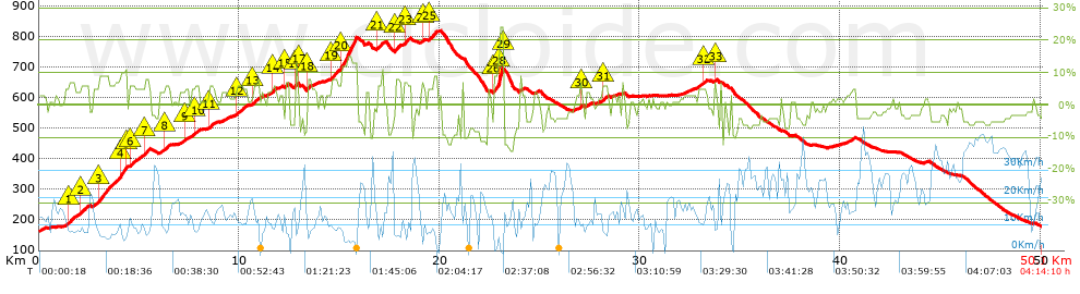
Distance in Km: 50.05
Climb in m: 1103
IBP: 66 BYC

Mario_Volpe
Author: Mario_Volpe
588 published routes

Add to my Group or Club

 Height in m      Climb in %      Speed in Km/h      Speed < 2 Km/h

Climbs > 5%

Climbs >5% Climbs >10% Climbs >15% Climbs >20% Climbs >25%
 Steep slope of 311 m.   Average slope  Distances  Download as waypoint
1
 Km 1.488  6%  311 m
 Steep slope of 434 m.  Average slope  Distances  Download as waypoint
2
 Km 2.073  6%  434 m
 Steep slope of 1480 m.  Average slope  Distances  Download as waypoint
3
 Km 2.944  8%  1116 m
4
 Km 4.06  10%  330 m
5
 Km 4.39  6%  34 m
 Steep slope of 274 m.  Average slope  Distances  Download as waypoint
6
 Km 4.525  5%  274 m
 Steep slope of 231 m.  Average slope  Distances  Download as waypoint
7
 Km 5.305  8%  231 m
 Steep slope of 248 m.  Average slope  Distances  Download as waypoint
8
 Km 6.297  6%  248 m
 Steep slope of 216 m.  Average slope  Distances  Download as waypoint
9
 Km 7.27  5%  216 m
 Steep slope of 208 m.  Average slope  Distances  Download as waypoint
10
 Km 7.794  6%  208 m
 Steep slope of 279 m.  Average slope  Distances  Download as waypoint
11
 Km 8.477  6%  279 m
 Steep slope of 532 m.  Average slope  Distances  Download as waypoint
12
 Km 9.875  6%  532 m
 Steep slope of 356 m.  Average slope  Distances  Download as waypoint
13
 Km 10.661  6%  356 m
 Steep slope of 171 m.  Average slope  Distances  Download as waypoint
14
 Km 11.673  6%  171 m
 Steep slope of 168 m.  Average slope  Distances  Download as waypoint
15
 Km 12.294  7%  168 m
 Steep slope of 136 m.  Average slope  Distances  Download as waypoint
16
 Km 12.816  13%  99 m
17
 Km 12.915  5%  37 m
 Steep slope of 168 m.  Average slope  Distances  Download as waypoint
18
 Km 13.404  8%  168 m
 Steep slope of 1297 m.  Average slope  Distances  Download as waypoint
19
 Km 14.586  7%  530 m
20
 Km 15.116  13%  767 m
 Steep slope of 345 m.  Average slope  Distances  Download as waypoint
21
 Km 16.859  7%  345 m
 Steep slope of 305 m.  Average slope  Distances  Download as waypoint
22
 Km 17.764  7%  305 m
 Steep slope of 303 m.  Average slope  Distances  Download as waypoint
23
 Km 18.245  7%  303 m
 Steep slope of 101 m.  Average slope  Distances  Download as waypoint
24
 Km 19.122  7%  101 m
 Steep slope of 473 m.  Average slope  Distances  Download as waypoint
25
 Km 19.42  7%  473 m
 Steep slope of 515 m.  Average slope  Distances  Download as waypoint
26
 Km 22.695  9%  225 m
27
 Km 22.92  14%  33 m
28
 Km 22.952  24%  223 m
29
 Km 23.175  11%  34 m
 Steep slope of 101 m.  Average slope  Distances  Download as waypoint
30
 Km 27.034  7%  101 m
 Steep slope of 237 m.  Average slope  Distances  Download as waypoint
31
 Km 28.122  6%  237 m
 Steep slope of 208 m.  Average slope  Distances  Download as waypoint
32
 Km 33.129  5%  208 m
 Steep slope of 100 m.  Average slope  Distances  Download as waypoint
33
 Km 33.734  7%  100 m


Description of the route


Presence of ramps


 Climbs  Distance  % of the total  Speed  Your speed would be  Time  Your time would be
   15 - 30%  0.223  0.45  3.99  ?  0:03:21  ?
   10 - 15%  1.295  2.59  6.4  ?  0:12:09  ?
   5 - 10%  7.987  15.96  8.6  ?  0:55:42  ?
   1 - 5%  12.018  24.01  12.89  ?  0:55:57  ?
   Total*  21.524 Km  43 %  10.16 Km/h  ? Km/h    2:07:09 h  ? h  
 Flat
   1 - -1%  6.883 Km  13.75 %  14.95 Km/h  ? Km/h    0:27:37 h  ? h  
 Descents
   -1 - -5%  13.189  26.35  21.69  ?  0:36:29  ?
   -5 - -10%  6.802  13.59  22.59  ?  0:18:04  ?
   -10 - -15%  1.742  3.48  17.23  ?  0:06:04  ?
   -15 - -30%  0  0  0  ?  0:00:00  ?
   Total*  21.733 Km  43.42 %  21.51 Km/h  ? Km/h    1:00:37 h  ? h  
* The total has not necessarily coincide with the sum of the partials after correction of errors

How long would it take you?

How long would it take you to cover this route?
There are routes without a valid time information, but with your average stats you can assess the possible duration

Mario_Volpe to cover this route you've need a time of:   3:35:23 h 
If you sign in and have a minimum of two tracks of this same modality, you can know your time for this route, calculated from your stats..


¿Cuanto consumirá tu E-BIKE?

Entra tu E-IBP (formato n,nn)

E-IBP :   X 66 = 


 Detected activity type =  ()
 Penalization due to track conditions: 51 %   ( > 50 % = MTB, < 50 % = RDB)
 Reliability of the track: C   (1219/50/1/16/-/66)
 Correction level applied to the track: 1        See analyis without corrections
DIFFICULTY OF THE ROUTE
IBP = 66 BYC
According to your statistics
 Your time in motion would be: ? h
Your average speed would be: ? Km/h
 

 Total Distance: 50.06 Km
 Analysed distance: 50.06 Km
 Linear distance: 0 Km

 Cumulated positive ramps: 1102.98 m  list of points info
 Cumulated negative ramps: 1094.84 m
 Maximum height: 818.11 m
 Minimum height: 162.4 m
 Climbing Ratio: 5.12 %
 Descent ratio: 5.04 %
 Cumulated postive ramps per Km: 22.03 m
 Cumulated negative ramps per Km: 21.87 m

 Total time: 4:14:10 h
 Time in movement: 3:35:23 h
 According to your statistics
 Your time in motion would be: ? h  
 Stopped time: 0:38:47 h
 Maximum slope filter: ~30 %
 Minimum separation analysed: ~30 m
 Number of points: 4053   (cad. 12.35 m)
 Significant waypoints: 1430   (cad. 35.03 m / 35.28 %)

 Changes in direction per Km: 12.7
 Changes in direction > 5º por Km: 6.75
 Cumulated straight stretches: 17.215 Km
 Straight stretches per Km: 343.89 m
 Penalized slope changes: 10
 Penalized slope changes per Km: 0.2

 Average speed in total: 11.82 Km/h
 Average speed while moving: 13.95 Km/h
 According to your statistics
 Your average speed would be: ? Km/h  
 Maximum sustained speed: 47.56 Km/h


Comments

You can be the first one in commenting this route

 
My comments
:
Add comment  (Registered users)
 
Notify me answers to my comment  Do not notify answers to my comment


Share this route with a friend

Your friend will receive a message with a link to this page:
will see your email and your user name if you do it as registered user.


Write here your name (optional)

E-mail address of your friend(s). You can include various addresses separated by commas

Text or comment (optional) maximum 255 characters long, 255 Available characters

As a non registered users you need to fill-in the captcha text.
  Change image
Type the image characters.
 
 Share with a friend


Visited history

Delete history

Marked routes for review later or compare

My favorites


  Notify anomaly in this route Share in Facebook