Virxe do Monte con 4 cracks!!

MTB
MTB
Ref..: 618661
Published: 18/02/2019
Performed: 16/02/2019
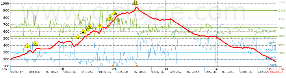
Distance in Km: 51.25
Climb in m: 1075
IBP: 79 BYC

Near ...
Aspera (San Cibrao Das Viñas), Astres, Barreiros Zona Comercial, Beiro (Ourense), Bemposta (Ourense), Bouza, A (Ourense)
Antonio Soto Domonte
388 published routes

Add to my Group or Club

 Height in m      Climb in %      Speed in Km/h      Speed < 2 Km/h

Climbs > 5%

Climbs >5% Climbs >10% Climbs >15% Climbs >20% Climbs >25%
 Steep slope of 234 m.   Average slope  Distances  Download as waypoint
1
 Km 2.151  5%  234 m
 Steep slope of 248 m.  Average slope  Distances  Download as waypoint
2
 Km 2.709  7%  248 m
 Steep slope of 198 m.  Average slope  Distances  Download as waypoint
3
 Km 3.243  8%  40 m
4
 Km 3.283  13%  158 m
 Steep slope of 294 m.  Average slope  Distances  Download as waypoint
5
 Km 4.387  10%  294 m
 Steep slope of 127 m.  Average slope  Distances  Download as waypoint
6
 Km 4.805  16%  127 m
 Steep slope of 126 m.  Average slope  Distances  Download as waypoint
7
 Km 7.722  7%  126 m
 Steep slope of 343 m.  Average slope  Distances  Download as waypoint
8
 Km 8.023  10%  343 m
 Steep slope of 204 m.  Average slope  Distances  Download as waypoint
9
 Km 8.553  8%  204 m
 Steep slope of 243 m.  Average slope  Distances  Download as waypoint
10
 Km 8.936  7%  243 m
 Steep slope of 131 m.  Average slope  Distances  Download as waypoint
11
 Km 10.33  5%  131 m
 Steep slope of 136 m.  Average slope  Distances  Download as waypoint
12
 Km 12.403  10%  136 m
 Steep slope of 279 m.  Average slope  Distances  Download as waypoint
13
 Km 13.096  12%  226 m
14
 Km 13.322  6%  53 m
 Steep slope of 313 m.  Average slope  Distances  Download as waypoint
15
 Km 13.506  6%  313 m
 Steep slope of 508 m.  Average slope  Distances  Download as waypoint
16
 Km 13.944  8%  82 m
17
 Km 14.026  10%  154 m
18
 Km 14.181  11%  272 m
 Steep slope of 248 m.  Average slope  Distances  Download as waypoint
19
 Km 14.758  11%  164 m
20
 Km 14.922  6%  84 m
 Steep slope of 300 m.  Average slope  Distances  Download as waypoint
21
 Km 15.242  7%  145 m
22
 Km 15.387  12%  124 m
23
 Km 15.511  7%  31 m
 Steep slope of 178 m.  Average slope  Distances  Download as waypoint
24
 Km 15.784  6%  178 m
 Steep slope of 591 m.  Average slope  Distances  Download as waypoint
25
 Km 17.208  15%  549 m
26
 Km 17.757  14%  42 m
 Steep slope of 368 m.  Average slope  Distances  Download as waypoint
27
 Km 18.51  10%  368 m
 Steep slope of 685 m.  Average slope  Distances  Download as waypoint
28
 Km 19.172  8%  32 m
29
 Km 19.204  16%  107 m
30
 Km 19.311  14%  74 m
31
 Km 19.385  8%  472 m
 Steep slope of 541 m.  Average slope  Distances  Download as waypoint
32
 Km 20.062  11%  460 m
33
 Km 20.522  5%  81 m
 Steep slope of 151 m.  Average slope  Distances  Download as waypoint
34
 Km 20.634  5%  151 m
 Steep slope of 204 m.  Average slope  Distances  Download as waypoint
35
 Km 21.292  8%  204 m
 Steep slope of 409 m.  Average slope  Distances  Download as waypoint
36
 Km 23.892  8%  153 m
37
 Km 24.045  12%  72 m
38
 Km 24.118  18%  184 m
 Steep slope of 99 m.  Average slope  Distances  Download as waypoint
39
 Km 30.853  9%  99 m


Description of the route


Presence of ramps


 Climbs  Distance  % of the total  Speed  Your speed would be  Time  Your time would be
   15 - 30%  0.673  1.31  5.5  ?  0:07:21  ?
   10 - 15%  2.959  5.77  7.16  ?  0:24:48  ?
   5 - 10%  4.337  8.46  9.31  ?  0:27:57  ?
   1 - 5%  9.871  19.26  13.74  ?  0:43:06  ?
   Total*  17.84 Km  34.81 %  10.37 Km/h  ? Km/h    1:43:12 h  ? h  
 Flat
   1 - -1%  8.131 Km  15.87 %  19.66 Km/h  ? Km/h    0:24:49 h  ? h  
 Descents
   -1 - -5%  17.011  33.19  27.65  ?  0:36:55  ?
   -5 - -10%  7.771  15.16  33.35  ?  0:13:59  ?
   -10 - -15%  0.423  0.83  26.71  ?  0:00:57  ?
   -15 - -30%  0.076  0.15  21.08  ?  0:00:13  ?
   Total*  25.281 Km  49.33 %  29.13 Km/h  ? Km/h    0:52:04 h  ? h  
* The total has not necessarily coincide with the sum of the partials after correction of errors

How long would it take you?

How long would it take you to cover this route?
There are routes without a valid time information, but with your average stats you can assess the possible duration

Antonio Soto Domonte to cover this route you've need a time of:   3:00:05 h 
If you sign in and have a minimum of two tracks of this same modality, you can know your time for this route, calculated from your stats..


¿Cuanto consumirá tu E-BIKE?

Entra tu E-IBP (formato n,nn)

E-IBP :   X 79 = 


 Detected activity type =  ()
 Penalization due to track conditions: 51 %   ( > 50 % = MTB, < 50 % = RDB)
 Reliability of the track: A   (1075/74/0/-/-/74)
 Correction level applied to the track: 0
DIFFICULTY OF THE ROUTE
IBP = 79 BYC
According to your statistics
 Your time in motion would be: ? h
Your average speed would be: ? Km/h
 

 Total Distance: 51.25 Km
 Analysed distance: 51.25 Km
 Linear distance: 0.73 Km

 Cumulated positive ramps: 1074.8 m  list of points info
 Cumulated negative ramps: 1110.2 m
 Maximum height: 952.1 m
 Minimum height: 168.3 m
 Climbing Ratio: 6.02 %
 Descent ratio: 4.39 %
 Cumulated postive ramps per Km: 20.97 m
 Cumulated negative ramps per Km: 21.66 m

 Total time: 3:22:55 h
 Time in movement: 3:00:05 h
 According to your statistics
 Your time in motion would be: ? h  
 Stopped time: 0:22:50 h
 Maximum slope filter: ~30 %
 Minimum separation analysed: ~30 m
 Number of points: 1662   (cad. 30.84 m)
 Significant waypoints: 993   (cad. 51.61 m / 59.75 %)

 Changes in direction per Km: 7.53
 Changes in direction > 5º por Km: 5.31
 Cumulated straight stretches: 12.273 Km
 Straight stretches per Km: 239.47 m
 Penalized slope changes: 10
 Penalized slope changes per Km: 0.195

 Average speed in total: 15.15 Km/h
 Average speed while moving: 17.08 Km/h
 According to your statistics
 Your average speed would be: ? Km/h  
 Maximum sustained speed: 60.74 Km/h


Comments

You can be the first one in commenting this route

 
My comments
:
Add comment  (Registered users)
 
Notify me answers to my comment  Do not notify answers to my comment


Share this route with a friend

Your friend will receive a message with a link to this page:
will see your email and your user name if you do it as registered user.


Write here your name (optional)

E-mail address of your friend(s). You can include various addresses separated by commas

Text or comment (optional) maximum 255 characters long, 255 Available characters

As a non registered users you need to fill-in the captcha text.
  Change image
Type the image characters.
 
 Share with a friend


Visited history

Delete history

Marked routes for review later or compare

My favorites


  Notify anomaly in this route Share in Facebook