Xivares (Asturias)

MTB
MTB
Ref..: 584792
Published: 14/01/2019
Performed: 11/01/2019
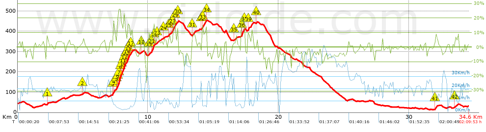
Distance in Km: 34.56
Climb in m: 806
IBP: 75 BYC

Near ...
Aroles, Bandin, Baragaña (Carreño), Barquera, La (Carreño), Barreres (Albandi_Carreño), Barreres (Pervera-Carreño)

 Height in m      Climb in %      Speed in Km/h      Speed < 2 Km/h

Climbs > 5%

Climbs >5% Climbs >10% Climbs >15% Climbs >20% Climbs >25%
 Steep slope of 99 m.   Average slope  Distances  Download as waypoint
1
 Km 2.224  10%  99 m
 Steep slope of 102 m.  Average slope  Distances  Download as waypoint
2
 Km 4.966  6%  102 m
 Steep slope of 210 m.  Average slope  Distances  Download as waypoint
3
 Km 7.273  6%  73 m
4
 Km 7.346  14%  137 m
 Steep slope of 1208 m.  Average slope  Distances  Download as waypoint
5
 Km 7.584  6%  33 m
6
 Km 7.617  18%  104 m
7
 Km 7.721  27%  144 m
8
 Km 7.865  11%  71 m
9
 Km 7.936  17%  42 m
10
 Km 7.979  15%  117 m
11
 Km 8.096  25%  34 m
12
 Km 8.129  21%  98 m
13
 Km 8.227  10%  136 m
14
 Km 8.363  17%  132 m
15
 Km 8.495  14%  95 m
16
 Km 8.59  8%  99 m
17
 Km 8.689  11%  103 m
 Steep slope of 105 m.  Average slope  Distances  Download as waypoint
18
 Km 9.432  7%  105 m
 Steep slope of 116 m.  Average slope  Distances  Download as waypoint
19
 Km 10.01  9%  116 m
 Steep slope of 246 m.  Average slope  Distances  Download as waypoint
20
 Km 10.27  7%  34 m
21
 Km 10.303  17%  145 m
22
 Km 10.449  13%  67 m
 Steep slope of 210 m.  Average slope  Distances  Download as waypoint
23
 Km 10.627  6%  210 m
 Steep slope of 105 m.  Average slope  Distances  Download as waypoint
24
 Km 11.216  6%  105 m
 Steep slope of 149 m.  Average slope  Distances  Download as waypoint
25
 Km 11.527  7%  149 m
 Steep slope of 515 m.  Average slope  Distances  Download as waypoint
26
 Km 11.78  7%  137 m
27
 Km 11.916  17%  164 m
28
 Km 12.08  15%  33 m
29
 Km 12.114  7%  113 m
30
 Km 12.227  13%  68 m
 Steep slope of 325 m.  Average slope  Distances  Download as waypoint
31
 Km 13.347  8%  325 m
 Steep slope of 407 m.  Average slope  Distances  Download as waypoint
32
 Km 14.101  7%  36 m
33
 Km 14.138  12%  305 m
34
 Km 14.443  12%  66 m
 Steep slope of 214 m.  Average slope  Distances  Download as waypoint
35
 Km 16.579  6%  214 m
 Steep slope of 270 m.  Average slope  Distances  Download as waypoint
36
 Km 17.141  16%  203 m
37
 Km 17.343  19%  34 m
38
 Km 17.377  16%  33 m
 Steep slope of 345 m.  Average slope  Distances  Download as waypoint
39
 Km 17.632  9%  345 m
 Steep slope of 111 m.  Average slope  Distances  Download as waypoint
40
 Km 18.258  6%  111 m
 Steep slope of 215 m.  Average slope  Distances  Download as waypoint
41
 Km 31.964  8%  215 m
 Steep slope of 224 m.  Average slope  Distances  Download as waypoint
42
 Km 33.485  6%  224 m


Description of the route


Presence of ramps


 Climbs  Distance  % of the total  Speed  Your speed would be  Time  Your time would be
   15 - 30%  1.284  3.71  5.69  ?  0:13:32  ?
   10 - 15%  1.109  3.21  6.57  ?  0:10:08  ?
   5 - 10%  3.262  9.44  9.79  ?  0:19:59  ?
   1 - 5%  7.049  20.4  14.48  ?  0:29:13  ?
   Total*  12.704 Km  36.76 %  10.46 Km/h  ? Km/h    1:12:52 h  ? h  
 Flat
   1 - -1%  6.246 Km  18.07 %  20.08 Km/h  ? Km/h    0:18:40 h  ? h  
 Descents
   -1 - -5%  9.268  26.82  23.95  ?  0:23:13  ?
   -5 - -10%  4.626  13.38  30.61  ?  0:09:04  ?
   -10 - -15%  1.335  3.86  28.61  ?  0:02:48  ?
   -15 - -30%  0.382  1.11  25.95  ?  0:00:53  ?
   Total*  15.611 Km  45.17 %  26.04 Km/h  ? Km/h    0:35:58 h  ? h  
* The total has not necessarily coincide with the sum of the partials after correction of errors

How long would it take you?

How long would it take you to cover this route?
There are routes without a valid time information, but with your average stats you can assess the possible duration

Juan Ramon Garcia Menendez to cover this route you've need a time of:   2:07:30 h 
If you sign in and have a minimum of two tracks of this same modality, you can know your time for this route, calculated from your stats..


¿Cuanto consumirá tu E-BIKE?

Entra tu E-IBP (formato n,nn)

E-IBP :   X 75 = 


 Detected activity type =  ()
 Penalization due to track conditions: 70 %   ( > 50 % = MTB, < 50 % = RDB)
 Reliability of the track: B   (806/67/0/-/-/67)
 Correction level applied to the track: 0
DIFFICULTY OF THE ROUTE
IBP = 75 BYC
According to your statistics
 Your time in motion would be: ? h
Your average speed would be: ? Km/h
 

 Total Distance: 34.56 Km
 Analysed distance: 34.56 Km
 Linear distance: 0.36 Km

 Cumulated positive ramps: 805.9 m  list of points info
 Cumulated negative ramps: 816.4 m
 Maximum height: 455.1 m
 Minimum height: 13.5 m
 Climbing Ratio: 6.34 %
 Descent ratio: 5.23 %
 Cumulated postive ramps per Km: 23.32 m
 Cumulated negative ramps per Km: 23.62 m

 Total time: 2:09:53 h
 Time in movement: 2:07:30 h
 According to your statistics
 Your time in motion would be: ? h  
 Stopped time: 0:02:23 h
 Maximum slope filter: ~30 %
 Minimum separation analysed: ~30 m
 Number of points: 2626   (cad. 13.16 m)
 Significant waypoints: 965   (cad. 35.82 m / 36.75 %)

 Changes in direction per Km: 10.53
 Changes in direction > 5º por Km: 7.23
 Cumulated straight stretches: 6.677 Km
 Straight stretches per Km: 193.2 m
 Penalized slope changes: 8
 Penalized slope changes per Km: 0.231

 Average speed in total: 15.97 Km/h
 Average speed while moving: 16.26 Km/h
 According to your statistics
 Your average speed would be: ? Km/h  
 Maximum sustained speed: 57.17 Km/h


Comments

You can be the first one in commenting this route

 
My comments
:
Add comment  (Registered users)
 
Notify me answers to my comment  Do not notify answers to my comment


Share this route with a friend

Your friend will receive a message with a link to this page:
will see your email and your user name if you do it as registered user.


Write here your name (optional)

E-mail address of your friend(s). You can include various addresses separated by commas

Text or comment (optional) maximum 255 characters long, 255 Available characters

As a non registered users you need to fill-in the captcha text.
  Change image
Type the image characters.
 
 Share with a friend


Visited history

Delete history

Marked routes for review later or compare

My favorites


  Notify anomaly in this route Share in Facebook