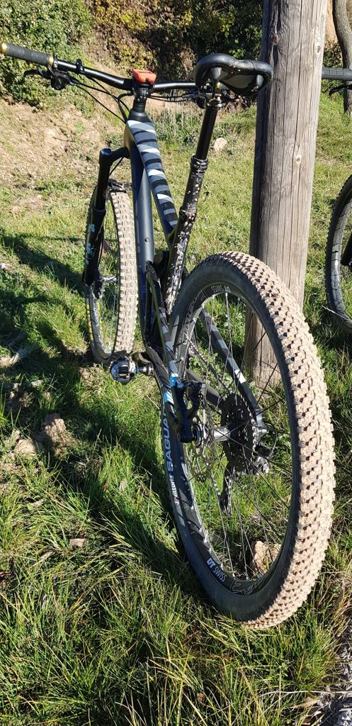
Granera con ruedas gordas!!!

MTB
MTB
Ref..: 571976
Published: 31/12/2018
Performed: 30/12/2018
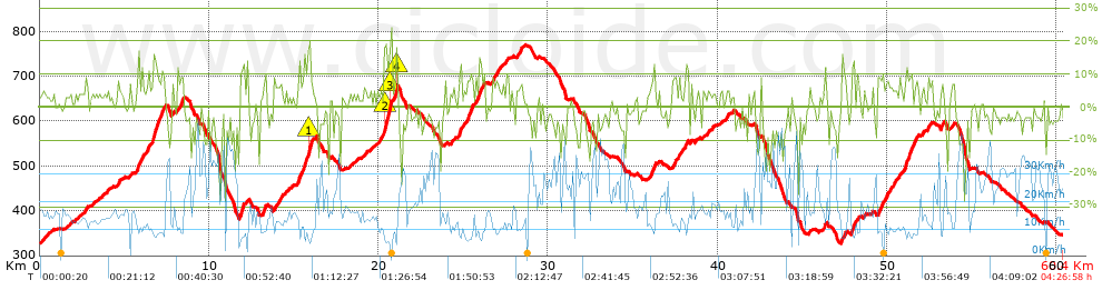
Distance in Km: 60.38
Climb in m: 1599
IBP: 113 BYC

Near ...
Fonts, Les (Terrassa), Matadepera, Pedritxes, Les, Sant Llorenç (Matadepera), Terrassa
Angel_Ortega_Lazaro
134 published routes

Add to my Group or Club

 Height in m      Climb in %      Speed in Km/h      Speed < 2 Km/h

Climbs > 5%

Climbs >5% Climbs >10% Climbs >15% Climbs >20% Climbs >25%
 Steep slope of 180 m.   Average slope  Distances  Download as waypoint
1
 Km 2.695  6%  180 m
 Steep slope of 145 m.  Average slope  Distances  Download as waypoint
2
 Km 4.585  7%  145 m
 Steep slope of 135 m.  Average slope  Distances  Download as waypoint
3
 Km 5.297  7%  135 m
 Steep slope of 390 m.  Average slope  Distances  Download as waypoint
4
 Km 5.704  9%  390 m
 Steep slope of 155 m.  Average slope  Distances  Download as waypoint
5
 Km 6.313  8%  155 m
 Steep slope of 795 m.  Average slope  Distances  Download as waypoint
6
 Km 6.591  6%  69 m
7
 Km 6.66  12%  451 m
8
 Km 7.111  9%  275 m
 Steep slope of 104 m.  Average slope  Distances  Download as waypoint
9
 Km 7.827  6%  104 m
 Steep slope of 290 m.  Average slope  Distances  Download as waypoint
10
 Km 8.148  9%  290 m
 Steep slope of 255 m.  Average slope  Distances  Download as waypoint
11
 Km 11.779  7%  111 m
12
 Km 11.89  12%  144 m
 Steep slope of 196 m.  Average slope  Distances  Download as waypoint
13
 Km 13.166  9%  110 m
14
 Km 13.276  12%  86 m
 Steep slope of 439 m.  Average slope  Distances  Download as waypoint
15
 Km 13.808  6%  439 m
 Steep slope of 810 m.  Average slope  Distances  Download as waypoint
16
 Km 15.229  6%  37 m
17
 Km 15.266  11%  110 m
18
 Km 15.376  8%  109 m
19
 Km 15.484  10%  151 m
20
 Km 15.635  12%  112 m
21
 Km 15.747  6%  97 m
22
 Km 15.844  17%  38 m
23
 Km 15.882  17%  116 m
24
 Km 15.998  19%  40 m
 Steep slope of 787 m.  Average slope  Distances  Download as waypoint
25
 Km 19.919  6%  392 m
26
 Km 20.311  17%  140 m
27
 Km 20.451  13%  176 m
28
 Km 20.628  16%  79 m
 Steep slope of 392 m.  Average slope  Distances  Download as waypoint
29
 Km 20.748  9%  123 m
30
 Km 20.872  7%  132 m
31
 Km 21.003  11%  29 m
32
 Km 21.032  17%  108 m
 Steep slope of 841 m.  Average slope  Distances  Download as waypoint
33
 Km 24.706  7%  61 m
34
 Km 24.767  14%  103 m
35
 Km 24.87  7%  677 m
 Steep slope of 365 m.  Average slope  Distances  Download as waypoint
36
 Km 25.726  9%  37 m
37
 Km 25.762  9%  259 m
38
 Km 26.021  11%  69 m
 Steep slope of 489 m.  Average slope  Distances  Download as waypoint
39
 Km 26.68  7%  489 m
 Steep slope of 323 m.  Average slope  Distances  Download as waypoint
40
 Km 28.15  7%  323 m
 Steep slope of 299 m.  Average slope  Distances  Download as waypoint
41
 Km 36.037  10%  299 m
 Steep slope of 424 m.  Average slope  Distances  Download as waypoint
42
 Km 37.322  7%  424 m
 Steep slope of 148 m.  Average slope  Distances  Download as waypoint
43
 Km 38.11  10%  148 m
 Steep slope of 114 m.  Average slope  Distances  Download as waypoint
44
 Km 45.416  6%  114 m
 Steep slope of 108 m.  Average slope  Distances  Download as waypoint
45
 Km 46.31  9%  108 m
 Steep slope of 258 m.  Average slope  Distances  Download as waypoint
46
 Km 47.308  9%  258 m
 Steep slope of 424 m.  Average slope  Distances  Download as waypoint
47
 Km 47.864  5%  40 m
48
 Km 47.904  13%  178 m
49
 Km 48.082  5%  206 m
 Steep slope of 1035 m.  Average slope  Distances  Download as waypoint
50
 Km 49.44  7%  1035 m
 Steep slope of 800 m.  Average slope  Distances  Download as waypoint
51
 Km 50.668  6%  389 m
52
 Km 51.058  11%  194 m
53
 Km 51.252  11%  217 m
 Steep slope of 208 m.  Average slope  Distances  Download as waypoint
54
 Km 51.61  9%  208 m
 Steep slope of 102 m.  Average slope  Distances  Download as waypoint
55
 Km 52.079  7%  102 m
 Steep slope of 137 m.  Average slope  Distances  Download as waypoint
56
 Km 52.373  8%  137 m
 Steep slope of 178 m.  Average slope  Distances  Download as waypoint
57
 Km 53.164  9%  178 m
 Steep slope of 122 m.  Average slope  Distances  Download as waypoint
58
 Km 53.839  7%  122 m


Description of the route


Presence of ramps


 Climbs  Distance  % of the total  Speed  Your speed would be  Time  Your time would be
   15 - 30%  0.86  1.42  8.22  ?  0:06:17  ?
   10 - 15%  2.978  4.93  8.84  ?  0:20:13  ?
   5 - 10%  9.658  15.99  10.97  ?  0:52:50  ?
   1 - 5%  13.732  22.74  14.48  ?  0:56:53  ?
   Total*  27.228 Km  45.1 %  11.99 Km/h  ? Km/h    2:16:13 h  ? h  
 Flat
   1 - -1%  8.275 Km  13.71 %  18.87 Km/h  ? Km/h    0:26:19 h  ? h  
 Descents
   -1 - -5%  13.121  21.73  24.65  ?  0:31:56  ?
   -5 - -10%  7.211  11.94  27.47  ?  0:15:45  ?
   -10 - -15%  2.759  4.57  27.59  ?  0:06:00  ?
   -15 - -30%  1.784  2.96  17.18  ?  0:06:14  ?
   Total*  24.876 Km  41.2 %  24.91 Km/h  ? Km/h    0:59:55 h  ? h  
* The total has not necessarily coincide with the sum of the partials after correction of errors

How long would it take you?

How long would it take you to cover this route?
There are routes without a valid time information, but with your average stats you can assess the possible duration

Angel_Ortega_Lazaro to cover this route you've need a time of:   3:42:27 h 
If you sign in and have a minimum of two tracks of this same modality, you can know your time for this route, calculated from your stats..


¿Cuanto consumirá tu E-BIKE?

Entra tu E-IBP (formato n,nn)

E-IBP :   X 113 = 


 Detected activity type =  ()
 Penalization due to track conditions: 65 %   ( > 50 % = MTB, < 50 % = RDB)
 Reliability of the track: A   (1606/75/0/-/-/75)
 Correction level applied to the track: 0
DIFFICULTY OF THE ROUTE
IBP = 113 BYC
According to your statistics
 Your time in motion would be: ? h
Your average speed would be: ? Km/h
 

 Total Distance: 60.38 Km
 Analysed distance: 60.38 Km
 Linear distance: 0.01 Km

 Cumulated positive ramps: 1598.73 m  list of points info
 Cumulated negative ramps: 1577.53 m
 Maximum height: 769 m
 Minimum height: 327 m
 Climbing Ratio: 5.87 %
 Descent ratio: 6.34 %
 Cumulated postive ramps per Km: 26.48 m
 Cumulated negative ramps per Km: 26.13 m

 Total time: 4:26:58 h
 Time in movement: 3:42:27 h
 According to your statistics
 Your time in motion would be: ? h  
 Stopped time: 0:44:31 h
 Maximum slope filter: ~30 %
 Minimum separation analysed: ~30 m
 Number of points: 2668   (cad. 22.63 m)
 Significant waypoints: 1406   (cad. 42.94 m / 52.7 %)

 Changes in direction per Km: 10.6
 Changes in direction > 5º por Km: 8.35
 Cumulated straight stretches: 9.374 Km
 Straight stretches per Km: 155.25 m
 Penalized slope changes: 15
 Penalized slope changes per Km: 0.248

 Average speed in total: 13.57 Km/h
 Average speed while moving: 16.29 Km/h
 According to your statistics
 Your average speed would be: ? Km/h  
 Maximum sustained speed: 51.2 Km/h


Comments

You can be the first one in commenting this route

 
My comments
:
Add comment  (Registered users)
 
Notify me answers to my comment  Do not notify answers to my comment


Share this route with a friend

Your friend will receive a message with a link to this page:
will see your email and your user name if you do it as registered user.


Write here your name (optional)

E-mail address of your friend(s). You can include various addresses separated by commas

Text or comment (optional) maximum 255 characters long, 255 Available characters

As a non registered users you need to fill-in the captcha text.
  Change image
Type the image characters.
 
 Share with a friend


Visited history

Delete history

Marked routes for review later or compare

My favorites


  Notify anomaly in this route Share in Facebook