Castell de Montsoriu

MTB
MTB
Ref..: 552060
Published: 09/12/2018
Performed: 09/12/2018
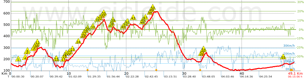
Distance in Km: 49.12
Climb in m: 1258
IBP: 98 BYC


 Height in m      Climb in %      Speed in Km/h      Speed < 2 Km/h

Climbs > 5%

Climbs >5% Climbs >10% Climbs >15% Climbs >20% Climbs >25%
 Steep slope of 107 m.   Average slope  Distances  Download as waypoint
1
 Km 1.3  9%  107 m
 Steep slope of 521 m.  Average slope  Distances  Download as waypoint
2
 Km 2.451  6%  33 m
3
 Km 2.484  15%  33 m
4
 Km 2.517  17%  225 m
5
 Km 2.742  15%  97 m
6
 Km 2.839  5%  133 m
 Steep slope of 359 m.  Average slope  Distances  Download as waypoint
7
 Km 3.887  9%  165 m
8
 Km 4.052  12%  130 m
9
 Km 4.182  11%  64 m
 Steep slope of 322 m.  Average slope  Distances  Download as waypoint
10
 Km 4.386  8%  31 m
11
 Km 4.417  12%  161 m
12
 Km 4.578  8%  130 m
 Steep slope of 191 m.  Average slope  Distances  Download as waypoint
13
 Km 7.786  7%  33 m
14
 Km 7.819  12%  93 m
15
 Km 7.912  5%  65 m
 Steep slope of 444 m.  Average slope  Distances  Download as waypoint
16
 Km 9.023  9%  93 m
17
 Km 9.116  14%  156 m
18
 Km 9.272  18%  32 m
19
 Km 9.303  10%  163 m
 Steep slope of 101 m.  Average slope  Distances  Download as waypoint
20
 Km 9.565  9%  101 m
 Steep slope of 105 m.  Average slope  Distances  Download as waypoint
21
 Km 9.956  7%  105 m
 Steep slope of 164 m.  Average slope  Distances  Download as waypoint
22
 Km 10.197  6%  164 m
 Steep slope of 705 m.  Average slope  Distances  Download as waypoint
23
 Km 10.691  7%  705 m
 Steep slope of 594 m.  Average slope  Distances  Download as waypoint
24
 Km 11.693  7%  594 m
 Steep slope of 460 m.  Average slope  Distances  Download as waypoint
25
 Km 12.42  7%  99 m
26
 Km 12.519  13%  195 m
27
 Km 12.714  7%  166 m
 Steep slope of 197 m.  Average slope  Distances  Download as waypoint
28
 Km 12.981  9%  197 m
 Steep slope of 167 m.  Average slope  Distances  Download as waypoint
29
 Km 13.313  8%  167 m
 Steep slope of 863 m.  Average slope  Distances  Download as waypoint
30
 Km 14.127  8%  831 m
31
 Km 14.958  12%  32 m
 Steep slope of 223 m.  Average slope  Distances  Download as waypoint
32
 Km 15.362  6%  223 m
 Steep slope of 99 m.  Average slope  Distances  Download as waypoint
33
 Km 15.785  9%  99 m
 Steep slope of 159 m.  Average slope  Distances  Download as waypoint
34
 Km 15.984  11%  127 m
35
 Km 16.111  13%  32 m
 Steep slope of 131 m.  Average slope  Distances  Download as waypoint
36
 Km 17.28  10%  34 m
37
 Km 17.315  13%  97 m
 Steep slope of 158 m.  Average slope  Distances  Download as waypoint
38
 Km 17.509  16%  127 m
39
 Km 17.637  20%  31 m
 Steep slope of 198 m.  Average slope  Distances  Download as waypoint
40
 Km 19.495  6%  198 m
 Steep slope of 199 m.  Average slope  Distances  Download as waypoint
41
 Km 19.828  6%  199 m
 Steep slope of 428 m.  Average slope  Distances  Download as waypoint
42
 Km 20.124  8%  428 m
 Steep slope of 97 m.  Average slope  Distances  Download as waypoint
43
 Km 21.176  9%  97 m
 Steep slope of 329 m.  Average slope  Distances  Download as waypoint
44
 Km 22.754  15%  128 m
45
 Km 22.882  17%  31 m
46
 Km 22.913  9%  170 m
 Steep slope of 603 m.  Average slope  Distances  Download as waypoint
47
 Km 23.227  7%  603 m
 Steep slope of 752 m.  Average slope  Distances  Download as waypoint
48
 Km 24.029  8%  327 m
49
 Km 24.356  11%  228 m
50
 Km 24.584  9%  197 m
 Steep slope of 705 m.  Average slope  Distances  Download as waypoint
51
 Km 32.931  12%  129 m
52
 Km 33.06  9%  160 m
53
 Km 33.221  12%  98 m
54
 Km 33.319  8%  318 m
 Steep slope of 141 m.  Average slope  Distances  Download as waypoint
55
 Km 47.149  6%  141 m


Description of the route


Presence of ramps


 Climbs  Distance  % of the total  Speed  Your speed would be  Time  Your time would be
   15 - 30%  0.773  1.57  4.73  ?  0:09:48  ?
   10 - 15%  2.352  4.79  6.32  ?  0:22:19  ?
   5 - 10%  7.751  15.78  7.73  ?  1:00:11  ?
   1 - 5%  9.946  20.25  11.49  ?  0:51:57  ?
   Total*  20.822 Km  42.39 %  8.66 Km/h  ? Km/h    2:24:15 h  ? h  
 Flat
   1 - -1%  7.692 Km  15.66 %  16.79 Km/h  ? Km/h    0:27:29 h  ? h  
 Descents
   -1 - -5%  11.091  22.58  17.17  ?  0:38:46  ?
   -5 - -10%  5.671  11.55  14.27  ?  0:23:51  ?
   -10 - -15%  2.47  5.03  12.67  ?  0:11:42  ?
   -15 - -30%  1.372  2.79  10.06  ?  0:08:11  ?
   Total*  20.604 Km  41.95 %  14.98 Km/h  ? Km/h    1:22:30 h  ? h  
* The total has not necessarily coincide with the sum of the partials after correction of errors

How long would it take you?

How long would it take you to cover this route?
There are routes without a valid time information, but with your average stats you can assess the possible duration

CC Sant Celoni to cover this route you've need a time of:   4:14:14 h 
If you sign in and have a minimum of two tracks of this same modality, you can know your time for this route, calculated from your stats..


¿Cuanto consumirá tu E-BIKE?

Entra tu E-IBP (formato n,nn)

E-IBP :   X 98 = 


 Detected activity type =  ()
 Penalization due to track conditions: 76 %   ( > 50 % = MTB, < 50 % = RDB)
 Reliability of the track: B   (1258/59/0/-/-/59)
 Correction level applied to the track: 0
DIFFICULTY OF THE ROUTE
IBP = 98 BYC
According to your statistics
 Your time in motion would be: ? h
Your average speed would be: ? Km/h
 

 Total Distance: 49.12 Km
 Analysed distance: 49.12 Km
 Linear distance: 0.21 Km

 Cumulated positive ramps: 1257.54 m  list of points info
 Cumulated negative ramps: 1248.34 m
 Maximum height: 615.8 m
 Minimum height: 101.6 m
 Climbing Ratio: 6.04 %
 Descent ratio: 6.06 %
 Cumulated postive ramps per Km: 25.6 m
 Cumulated negative ramps per Km: 25.41 m

 Total time: 6:15:06 h
 Time in movement: 4:14:14 h
 According to your statistics
 Your time in motion would be: ? h  
 Stopped time: 2:00:52 h
 Maximum slope filter: ~30 %
 Minimum separation analysed: ~30 m
 Number of points: 4151   (cad. 11.83 m)
 Significant waypoints: 1412   (cad. 34.79 m / 34.02 %)

 Changes in direction per Km: 12.85
 Changes in direction > 5º por Km: 9.71
 Cumulated straight stretches: 8.963 Km
 Straight stretches per Km: 182.47 m
 Penalized slope changes: 13
 Penalized slope changes per Km: 0.265

 Average speed in total: 7.86 Km/h
 Average speed while moving: 11.59 Km/h
 According to your statistics
 Your average speed would be: ? Km/h  
 Maximum sustained speed: 34.58 Km/h


Comments

You can be the first one in commenting this route

 
My comments
:
Add comment  (Registered users)
 
Notify me answers to my comment  Do not notify answers to my comment


Share this route with a friend

Your friend will receive a message with a link to this page:
will see your email and your user name if you do it as registered user.


Write here your name (optional)

E-mail address of your friend(s). You can include various addresses separated by commas

Text or comment (optional) maximum 255 characters long, 255 Available characters

As a non registered users you need to fill-in the captcha text.
  Change image
Type the image characters.
 
 Share with a friend


Visited history

Delete history

Marked routes for review later or compare

My favorites


  Notify anomaly in this route Share in Facebook