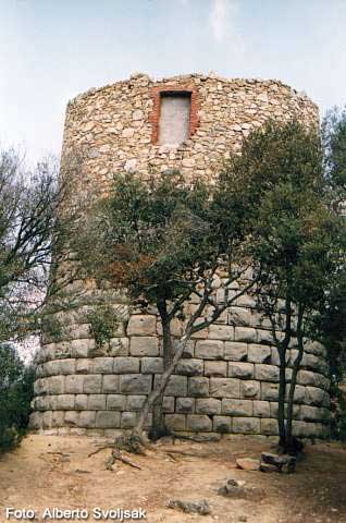
Sant Celoni - El Far - La Torrassa Del Moro - Sa Nata - Sant Celoni

MTB
MTB
Ref..: 53
Published: 09/01/2005
Performed: 09/01/2005
Distance in Km: 48.55
Climb in m: 1080
IBP: 88 BYC

Guan
Author: Guan
341 published routes

Add to my Group or Club

 Height in m      Climb in %      Speed in Km/h      Speed < 2 Km/h

Climbs > 5%

Climbs >5% Climbs >10% Climbs >15% Climbs >20% Climbs >25%
 Steep slope of 236 m.   Average slope  Distances  Download as waypoint
1
 Km 0.488  6%  83 m
2
 Km 0.571  24%  112 m
3
 Km 0.683  16%  41 m
 Steep slope of 589 m.  Average slope  Distances  Download as waypoint
4
 Km 4.993  6%  381 m
5
 Km 5.374  17%  170 m
6
 Km 5.543  18%  38 m
 Steep slope of 682 m.  Average slope  Distances  Download as waypoint
7
 Km 6.006  7%  169 m
8
 Km 6.175  8%  513 m
 Steep slope of 459 m.  Average slope  Distances  Download as waypoint
9
 Km 10.154  8%  459 m
 Steep slope of 139 m.  Average slope  Distances  Download as waypoint
10
 Km 10.825  9%  139 m
 Steep slope of 523 m.  Average slope  Distances  Download as waypoint
11
 Km 11.51  13%  96 m
12
 Km 11.606  23%  110 m
13
 Km 11.717  10%  149 m
14
 Km 11.866  22%  37 m
15
 Km 11.903  23%  91 m
16
 Km 11.993  8%  40 m
 Steep slope of 521 m.  Average slope  Distances  Download as waypoint
17
 Km 12.076  14%  88 m
18
 Km 12.165  15%  112 m
19
 Km 12.276  10%  105 m
20
 Km 12.382  13%  216 m
 Steep slope of 216 m.  Average slope  Distances  Download as waypoint
21
 Km 12.992  6%  51 m
22
 Km 13.043  11%  110 m
23
 Km 13.153  10%  55 m
 Steep slope of 407 m.  Average slope  Distances  Download as waypoint
24
 Km 13.769  6%  407 m
 Steep slope of 155 m.  Average slope  Distances  Download as waypoint
25
 Km 17.071  9%  155 m
 Steep slope of 173 m.  Average slope  Distances  Download as waypoint
26
 Km 23.09  5%  173 m
 Steep slope of 175 m.  Average slope  Distances  Download as waypoint
27
 Km 23.429  9%  175 m
 Steep slope of 575 m.  Average slope  Distances  Download as waypoint
28
 Km 24.519  5%  285 m
29
 Km 24.804  8%  108 m
30
 Km 24.911  13%  107 m
31
 Km 25.019  13%  75 m
 Steep slope of 133 m.  Average slope  Distances  Download as waypoint
32
 Km 25.222  6%  133 m
 Steep slope of 386 m.  Average slope  Distances  Download as waypoint
33
 Km 35.033  8%  386 m
 Steep slope of 204 m.  Average slope  Distances  Download as waypoint
34
 Km 38.773  14%  117 m
35
 Km 38.89  5%  87 m


Description of the route


La Torrassa del Moro


Presence of ramps


 Climbs  Distance  % of the total  Speed  Your speed would be  Time  Your time would be
   15 - 30%  1.119  2.3  5.68  ?  0:11:49  ?
   10 - 15%  1.382  2.85  6.64  ?  0:12:29  ?
   5 - 10%  5.224  10.76  8.42  ?  0:37:13  ?
   1 - 5%  11.568  23.83  11.32  ?  1:01:18  ?
   Total*  19.292 Km  39.74 %  9.42 Km/h  ? Km/h    2:02:49 h  ? h  
 Flat
   1 - -1%  9.535 Km  19.64 %  13 Km/h  ? Km/h    0:44:01 h  ? h  
 Descents
   -1 - -5%  12.921  26.61  14.8  ?  0:52:23  ?
   -5 - -10%  4.384  9.03  19.04  ?  0:13:49  ?
   -10 - -15%  1.401  2.88  14.12  ?  0:05:57  ?
   -15 - -30%  1.015  2.09  8.19  ?  0:07:26  ?
   Total*  19.72 Km  40.62 %  14.87 Km/h  ? Km/h    1:19:35 h  ? h  
* The total has not necessarily coincide with the sum of the partials after correction of errors

How long would it take you?

How long would it take you to cover this route?
There are routes without a valid time information, but with your average stats you can assess the possible duration

Guan to cover this route you've need a time of:   4:06:25 h 
If you sign in and have a minimum of two tracks of this same modality, you can know your time for this route, calculated from your stats..


¿Cuanto consumirá tu E-BIKE?

Entra tu E-IBP (formato n,nn)

E-IBP :   X 88 = 


 Detected activity type =  ()
 Penalization due to track conditions: 73 %   ( > 50 % = MTB, < 50 % = RDB)
 Reliability of the track: B   (1081/59/0/-/-/59)
 Correction level applied to the track: 0
DIFFICULTY OF THE ROUTE
IBP = 88 BYC
According to your statistics
 Your time in motion would be: ? h
Your average speed would be: ? Km/h
 

 Total Distance: 48.55 Km
 Analysed distance: 48.55 Km
 Linear distance: 0.7 Km

 Cumulated positive ramps: 1080.1 m  list of points info
 Cumulated negative ramps: 1033.1 m
 Maximum height: 571.2 m
 Minimum height: 104.6 m
 Climbing Ratio: 5.6 %
 Descent ratio: 5.24 %
 Cumulated postive ramps per Km: 22.25 m
 Cumulated negative ramps per Km: 21.28 m

 Total time: 5:27:22 h
 Time in movement: 4:06:25 h
 According to your statistics
 Your time in motion would be: ? h  
 Stopped time: 1:20:57 h
 Maximum slope filter: ~30 %
 Minimum separation analysed: ~30 m
 Number of points: 1133   (cad. 42.85 m)
 Significant waypoints: 811   (cad. 59.86 m / 71.58 %)

 Changes in direction per Km: 7.68
 Changes in direction > 5º por Km: 6.41
 Cumulated straight stretches: 5.93 Km
 Straight stretches per Km: 122.14 m
 Penalized slope changes: 9
 Penalized slope changes per Km: 0.185

 Average speed in total: 8.9 Km/h
 Average speed while moving: 11.82 Km/h
 According to your statistics
 Your average speed would be: ? Km/h  
 Maximum sustained speed: 39.94 Km/h


Comments

You can be the first one in commenting this route

 
My comments
:
Add comment  (Registered users)
 
Notify me answers to my comment  Do not notify answers to my comment


Share this route with a friend

Your friend will receive a message with a link to this page:
will see your email and your user name if you do it as registered user.


Write here your name (optional)

E-mail address of your friend(s). You can include various addresses separated by commas

Text or comment (optional) maximum 255 characters long, 255 Available characters

As a non registered users you need to fill-in the captcha text.
  Change image
Type the image characters.
 
 Share with a friend


Visited history

Delete history

Marked routes for review later or compare

My favorites


  Notify anomaly in this route Share in Facebook