XCM Villalonga

MTB
MTB
Ref..: 481023
Published: 16/09/2018
Performed: 16/09/2018
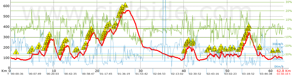
Distance in Km: 62.76
Climb in m: 1970
IBP: 174 BYC

Juan_Piera_Mota
273 published routes

Add to my Group or Club

 Height in m      Climb in %      Speed in Km/h      Speed < 2 Km/h

Climbs > 5%

Climbs >5% Climbs >10% Climbs >15% Climbs >20% Climbs >25%
 Steep slope of 109 m.   Average slope  Distances  Download as waypoint
1
 Km 1.321  7%  109 m
 Steep slope of 108 m.  Average slope  Distances  Download as waypoint
2
 Km 4.438  7%  108 m
 Steep slope of 301 m.  Average slope  Distances  Download as waypoint
3
 Km 4.817  14%  113 m
4
 Km 4.931  8%  188 m
 Steep slope of 315 m.  Average slope  Distances  Download as waypoint
5
 Km 6.403  11%  207 m
6
 Km 6.611  11%  108 m
 Steep slope of 1172 m.  Average slope  Distances  Download as waypoint
7
 Km 7.731  6%  161 m
8
 Km 7.893  10%  188 m
9
 Km 8.081  16%  102 m
10
 Km 8.183  20%  38 m
11
 Km 8.221  11%  148 m
12
 Km 8.37  12%  118 m
13
 Km 8.488  8%  145 m
14
 Km 8.633  15%  36 m
15
 Km 8.669  17%  118 m
16
 Km 8.787  9%  118 m
 Steep slope of 353 m.  Average slope  Distances  Download as waypoint
17
 Km 8.935  9%  353 m
 Steep slope of 1047 m.  Average slope  Distances  Download as waypoint
18
 Km 11.464  13%  272 m
19
 Km 11.736  5%  130 m
20
 Km 11.866  10%  115 m
21
 Km 11.981  15%  31 m
22
 Km 12.013  16%  78 m
23
 Km 12.09  5%  106 m
24
 Km 12.196  14%  283 m
25
 Km 12.479  11%  32 m
 Steep slope of 99 m.  Average slope  Distances  Download as waypoint
26
 Km 12.858  11%  99 m
 Steep slope of 113 m.  Average slope  Distances  Download as waypoint
27
 Km 14.982  5%  113 m
 Steep slope of 491 m.  Average slope  Distances  Download as waypoint
28
 Km 15.353  8%  491 m
 Steep slope of 1168 m.  Average slope  Distances  Download as waypoint
29
 Km 16.898  7%  502 m
30
 Km 17.4  15%  342 m
31
 Km 17.742  15%  181 m
32
 Km 17.924  12%  108 m
33
 Km 18.031  11%  35 m
 Steep slope of 590 m.  Average slope  Distances  Download as waypoint
34
 Km 18.295  9%  35 m
35
 Km 18.33  16%  114 m
36
 Km 18.443  8%  105 m
37
 Km 18.548  11%  112 m
38
 Km 18.66  6%  224 m
 Steep slope of 916 m.  Average slope  Distances  Download as waypoint
39
 Km 21.106  10%  141 m
40
 Km 21.247  10%  196 m
41
 Km 21.442  17%  104 m
42
 Km 21.547  14%  67 m
43
 Km 21.614  7%  192 m
44
 Km 21.806  11%  216 m
 Steep slope of 221 m.  Average slope  Distances  Download as waypoint
45
 Km 22.149  12%  180 m
46
 Km 22.329  15%  41 m
 Steep slope of 269 m.  Average slope  Distances  Download as waypoint
47
 Km 22.762  7%  269 m
 Steep slope of 412 m.  Average slope  Distances  Download as waypoint
48
 Km 23.735  9%  412 m
 Steep slope of 1248 m.  Average slope  Distances  Download as waypoint
49
 Km 24.291  12%  704 m
50
 Km 24.995  10%  289 m
51
 Km 25.284  13%  110 m
52
 Km 25.394  7%  114 m
53
 Km 25.508  11%  31 m
 Steep slope of 276 m.  Average slope  Distances  Download as waypoint
54
 Km 25.656  14%  120 m
55
 Km 25.777  11%  156 m
 Steep slope of 336 m.  Average slope  Distances  Download as waypoint
56
 Km 26.436  6%  336 m
 Steep slope of 687 m.  Average slope  Distances  Download as waypoint
57
 Km 40.077  8%  37 m
58
 Km 40.115  14%  30 m
59
 Km 40.145  18%  361 m
60
 Km 40.506  13%  187 m
61
 Km 40.693  14%  72 m
 Steep slope of 155 m.  Average slope  Distances  Download as waypoint
62
 Km 40.974  11%  120 m
63
 Km 41.095  11%  35 m
 Steep slope of 242 m.  Average slope  Distances  Download as waypoint
64
 Km 41.818  8%  101 m
65
 Km 41.92  13%  107 m
66
 Km 42.027  6%  34 m
 Steep slope of 130 m.  Average slope  Distances  Download as waypoint
67
 Km 45.311  13%  130 m
 Steep slope of 221 m.  Average slope  Distances  Download as waypoint
68
 Km 45.874  8%  221 m
 Steep slope of 329 m.  Average slope  Distances  Download as waypoint
69
 Km 46.894  7%  33 m
70
 Km 46.927  9%  93 m
71
 Km 47.02  8%  203 m
 Steep slope of 478 m.  Average slope  Distances  Download as waypoint
72
 Km 48.195  5%  38 m
73
 Km 48.233  12%  228 m
74
 Km 48.461  10%  108 m
75
 Km 48.568  20%  104 m
 Steep slope of 236 m.  Average slope  Distances  Download as waypoint
76
 Km 49.539  6%  236 m
 Steep slope of 157 m.  Average slope  Distances  Download as waypoint
77
 Km 50.589  14%  120 m
78
 Km 50.709  9%  37 m
 Steep slope of 192 m.  Average slope  Distances  Download as waypoint
79
 Km 51.46  8%  192 m
 Steep slope of 116 m.  Average slope  Distances  Download as waypoint
80
 Km 52.587  5%  116 m
 Steep slope of 883 m.  Average slope  Distances  Download as waypoint
81
 Km 53.135  18%  234 m
82
 Km 53.369  13%  402 m
83
 Km 53.771  9%  247 m
 Steep slope of 879 m.  Average slope  Distances  Download as waypoint
84
 Km 54.151  13%  195 m
85
 Km 54.346  6%  105 m
86
 Km 54.451  12%  38 m
87
 Km 54.489  18%  158 m
88
 Km 54.647  7%  112 m
89
 Km 54.759  11%  176 m
90
 Km 54.935  9%  95 m
 Steep slope of 214 m.  Average slope  Distances  Download as waypoint
91
 Km 57.341  10%  41 m
92
 Km 57.382  15%  105 m
93
 Km 57.488  19%  68 m
 Steep slope of 108 m.  Average slope  Distances  Download as waypoint
94
 Km 60.434  7%  108 m
 Steep slope of 119 m.  Average slope  Distances  Download as waypoint
95
 Km 61.706  5%  119 m


Description of the route


Presence of ramps


 Climbs  Distance  % of the total  Speed  Your speed would be  Time  Your time would be
   15 - 30%  2.52  4.01  6.1  ?  0:24:47  ?
   10 - 15%  6.078  9.69  8.36  ?  0:43:37  ?
   5 - 10%  7.216  11.5  11.19  ?  0:38:42  ?
   1 - 5%  9.029  14.39  18.59  ?  0:29:09  ?
   Total*  24.844 Km  39.59 %  10.94 Km/h  ? Km/h    2:16:15 h  ? h  
 Flat
   1 - -1%  9.7 Km  15.46 %  23.8 Km/h  ? Km/h    0:24:27 h  ? h  
 Descents
   -1 - -5%  13.88  22.12  26.61  ?  0:31:18  ?
   -5 - -10%  6.993  11.14  24.28  ?  0:17:17  ?
   -10 - -15%  4.444  7.08  17.94  ?  0:14:52  ?
   -15 - -30%  2.9  4.62  12.3  ?  0:14:09  ?
   Total*  28.217 Km  44.96 %  21.82 Km/h  ? Km/h    1:17:36 h  ? h  
* The total has not necessarily coincide with the sum of the partials after correction of errors

How long would it take you?

How long would it take you to cover this route?
There are routes without a valid time information, but with your average stats you can assess the possible duration

Juan_Piera_Mota to cover this route you've need a time of:   3:58:18 h 
If you sign in and have a minimum of two tracks of this same modality, you can know your time for this route, calculated from your stats..


¿Cuanto consumirá tu E-BIKE?

Entra tu E-IBP (formato n,nn)

E-IBP :   X 174 = 


 Detected activity type =  ()
 Penalization due to track conditions: 80 %   ( > 50 % = MTB, < 50 % = RDB)
 Reliability of the track: B   (1969/61/0/-/-/61)
 Correction level applied to the track: 0
DIFFICULTY OF THE ROUTE
IBP = 174 BYC
According to your statistics
 Your time in motion would be: ? h
Your average speed would be: ? Km/h
 

 Total Distance: 62.76 Km
 Analysed distance: 62.76 Km
 Linear distance: 0.01 Km

 Cumulated positive ramps: 1969.8 m  list of points info
 Cumulated negative ramps: 1966.2 m
 Maximum height: 558.8 m
 Minimum height: 72 m
 Climbing Ratio: 7.93 %
 Descent ratio: 6.97 %
 Cumulated postive ramps per Km: 31.39 m
 Cumulated negative ramps per Km: 31.33 m

 Total time: 3:58:18 h
 Time in movement: 3:58:18 h
 According to your statistics
 Your time in motion would be: ? h  
 Stopped time: 0:00:00 h
 Maximum slope filter: ~30 %
 Minimum separation analysed: ~30 m
 Number of points: 3410   (cad. 18.4 m)
 Significant waypoints: 1551   (cad. 40.46 m / 45.48 %)

 Changes in direction per Km: 10.25
 Changes in direction > 5º por Km: 7.57
 Cumulated straight stretches: 10.308 Km
 Straight stretches per Km: 164.24 m
 Penalized slope changes: 21
 Penalized slope changes per Km: 0.335

 Average speed in total: 15.8 Km/h
 Average speed while moving: 15.8 Km/h
 According to your statistics
 Your average speed would be: ? Km/h  
 Maximum sustained speed: 55.46 Km/h


Comments

You can be the first one in commenting this route

 
My comments
:
Add comment  (Registered users)
 
Notify me answers to my comment  Do not notify answers to my comment


Share this route with a friend

Your friend will receive a message with a link to this page:
will see your email and your user name if you do it as registered user.


Write here your name (optional)

E-mail address of your friend(s). You can include various addresses separated by commas

Text or comment (optional) maximum 255 characters long, 255 Available characters

As a non registered users you need to fill-in the captcha text.
  Change image
Type the image characters.
 
 Share with a friend


Visited history

Delete history

Marked routes for review later or compare

My favorites


  Notify anomaly in this route Share in Facebook