Real-Alto Millares-Real

MTB
MTB
Ref..: 469841
Published: 03/09/2018
Performed: 02/09/2018
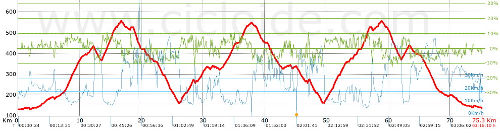
Distance in Km: 75.33
Climb in m: 1515
IBP: 95 BYC


 Height in m      Climb in %      Speed in Km/h      Speed < 2 Km/h

Climbs > 5%

Climbs >5% Climbs >10% Climbs >15% Climbs >20% Climbs >25%
 Steep slope of 218 m.   Average slope  Distances  Download as waypoint
1
 Km 7.66  5%  218 m
 Steep slope of 469 m.  Average slope  Distances  Download as waypoint
2
 Km 7.995  7%  469 m
 Steep slope of 600 m.  Average slope  Distances  Download as waypoint
3
 Km 8.564  7%  600 m
 Steep slope of 465 m.  Average slope  Distances  Download as waypoint
4
 Km 9.27  6%  465 m
 Steep slope of 145 m.  Average slope  Distances  Download as waypoint
5
 Km 9.871  6%  145 m
 Steep slope of 102 m.  Average slope  Distances  Download as waypoint
6
 Km 11.223  6%  102 m
 Steep slope of 627 m.  Average slope  Distances  Download as waypoint
7
 Km 13.64  7%  627 m
 Steep slope of 1274 m.  Average slope  Distances  Download as waypoint
8
 Km 14.355  8%  1274 m
 Steep slope of 122 m.  Average slope  Distances  Download as waypoint
9
 Km 15.77  6%  122 m
 Steep slope of 146 m.  Average slope  Distances  Download as waypoint
10
 Km 16.143  6%  146 m
 Steep slope of 194 m.  Average slope  Distances  Download as waypoint
11
 Km 16.512  6%  194 m
 Steep slope of 118 m.  Average slope  Distances  Download as waypoint
12
 Km 18.206  8%  118 m
 Steep slope of 297 m.  Average slope  Distances  Download as waypoint
13
 Km 26.311  6%  297 m
 Steep slope of 174 m.  Average slope  Distances  Download as waypoint
14
 Km 27.427  6%  174 m
 Steep slope of 305 m.  Average slope  Distances  Download as waypoint
15
 Km 27.748  6%  305 m
 Steep slope of 218 m.  Average slope  Distances  Download as waypoint
16
 Km 28.166  7%  218 m
 Steep slope of 159 m.  Average slope  Distances  Download as waypoint
17
 Km 29.193  5%  159 m
 Steep slope of 327 m.  Average slope  Distances  Download as waypoint
18
 Km 29.719  7%  327 m
 Steep slope of 101 m.  Average slope  Distances  Download as waypoint
19
 Km 31.4  7%  101 m
 Steep slope of 206 m.  Average slope  Distances  Download as waypoint
20
 Km 33.272  6%  206 m
 Steep slope of 218 m.  Average slope  Distances  Download as waypoint
21
 Km 34.011  6%  218 m
 Steep slope of 685 m.  Average slope  Distances  Download as waypoint
22
 Km 34.4  7%  685 m
 Steep slope of 220 m.  Average slope  Distances  Download as waypoint
23
 Km 35.864  6%  220 m
 Steep slope of 682 m.  Average slope  Distances  Download as waypoint
24
 Km 36.304  7%  682 m
 Steep slope of 186 m.  Average slope  Distances  Download as waypoint
25
 Km 46.995  8%  186 m
 Steep slope of 151 m.  Average slope  Distances  Download as waypoint
26
 Km 49.703  7%  151 m
 Steep slope of 319 m.  Average slope  Distances  Download as waypoint
27
 Km 50.029  6%  319 m
 Steep slope of 211 m.  Average slope  Distances  Download as waypoint
28
 Km 50.615  5%  211 m
 Steep slope of 826 m.  Average slope  Distances  Download as waypoint
29
 Km 51.02  7%  826 m
 Steep slope of 494 m.  Average slope  Distances  Download as waypoint
30
 Km 52.156  7%  494 m
 Steep slope of 272 m.  Average slope  Distances  Download as waypoint
31
 Km 52.751  6%  272 m
 Steep slope of 135 m.  Average slope  Distances  Download as waypoint
32
 Km 53.695  5%  135 m
 Steep slope of 137 m.  Average slope  Distances  Download as waypoint
33
 Km 54.283  8%  137 m
 Steep slope of 339 m.  Average slope  Distances  Download as waypoint
34
 Km 54.862  7%  339 m
 Steep slope of 134 m.  Average slope  Distances  Download as waypoint
35
 Km 55.588  6%  134 m
 Steep slope of 254 m.  Average slope  Distances  Download as waypoint
36
 Km 55.843  10%  138 m
37
 Km 55.981  9%  116 m
 Steep slope of 712 m.  Average slope  Distances  Download as waypoint
38
 Km 56.22  6%  81 m
39
 Km 56.302  11%  155 m
40
 Km 56.456  10%  113 m
41
 Km 56.569  9%  145 m
42
 Km 56.714  9%  218 m
 Steep slope of 208 m.  Average slope  Distances  Download as waypoint
43
 Km 58.359  7%  208 m
 Steep slope of 105 m.  Average slope  Distances  Download as waypoint
44
 Km 58.784  6%  105 m
 Steep slope of 212 m.  Average slope  Distances  Download as waypoint
45
 Km 62.193  5%  212 m
 Steep slope of 501 m.  Average slope  Distances  Download as waypoint
46
 Km 62.52  6%  501 m
 Steep slope of 151 m.  Average slope  Distances  Download as waypoint
47
 Km 63.145  5%  151 m


Description of the route


Presence of ramps


 Climbs  Distance  % of the total  Speed  Your speed would be  Time  Your time would be
   15 - 30%  0  0  0  ?  0:00:00  ?
   10 - 15%  1.156  1.54  10.95  ?  0:06:20  ?
   5 - 10%  14.07  18.68  13.98  ?  1:00:22  ?
   1 - 5%  13.255  17.6  18.16  ?  0:43:48  ?
   Total*  28.481 Km  37.81 %  15.46 Km/h  ? Km/h    1:50:30 h  ? h  
 Flat
   1 - -1%  18.816 Km  24.98 %  25.69 Km/h  ? Km/h    0:43:57 h  ? h  
 Descents
   -1 - -5%  12.307  16.34  39  ?  0:18:56  ?
   -5 - -10%  14.745  19.58  46.98  ?  0:18:50  ?
   -10 - -15%  0.977  1.3  51.7  ?  0:01:08  ?
   -15 - -30%  0  0  0  ?  0:00:00  ?
   Total*  28.029 Km  37.21 %  43.23 Km/h  ? Km/h    0:38:54 h  ? h  
* The total has not necessarily coincide with the sum of the partials after correction of errors

How long would it take you?

How long would it take you to cover this route?
There are routes without a valid time information, but with your average stats you can assess the possible duration

Agustin_Perez_Senchermes to cover this route you've need a time of:   3:13:21 h 
If you sign in and have a minimum of two tracks of this same modality, you can know your time for this route, calculated from your stats..


¿Cuanto consumirá tu E-BIKE?

Entra tu E-IBP (formato n,nn)

E-IBP :   X 95 = 


 Detected activity type =  ()
 Penalization due to track conditions: 55 %   ( > 50 % = MTB, < 50 % = RDB)
 Reliability of the track: A   (1515/93/0/-/-/93)
 Correction level applied to the track: 0
DIFFICULTY OF THE ROUTE
IBP = 95 BYC
According to your statistics
 Your time in motion would be: ? h
Your average speed would be: ? Km/h
 

 Total Distance: 75.33 Km
 Analysed distance: 75.33 Km
 Linear distance: 0.02 Km

 Cumulated positive ramps: 1515 m  list of points info
 Cumulated negative ramps: 1509.4 m
 Maximum height: 557 m
 Minimum height: 131.2 m
 Climbing Ratio: 5.32 %
 Descent ratio: 5.39 %
 Cumulated postive ramps per Km: 20.11 m
 Cumulated negative ramps per Km: 20.04 m

 Total time: 3:16:10 h
 Time in movement: 3:13:21 h
 According to your statistics
 Your time in motion would be: ? h  
 Stopped time: 0:02:49 h
 Maximum slope filter: ~30 %
 Minimum separation analysed: ~30 m
 Number of points: 4381   (cad. 17.19 m)
 Significant waypoints: 1907   (cad. 39.5 m / 43.53 %)

 Changes in direction per Km: 8.55
 Changes in direction > 5º por Km: 6.35
 Cumulated straight stretches: 16.017 Km
 Straight stretches per Km: 212.62 m
 Penalized slope changes: 14
 Penalized slope changes per Km: 0.186

 Average speed in total: 23.04 Km/h
 Average speed while moving: 23.38 Km/h
 According to your statistics
 Your average speed would be: ? Km/h  
 Maximum sustained speed: 71.95 Km/h


Comments

You can be the first one in commenting this route

 
My comments
:
Add comment  (Registered users)
 
Notify me answers to my comment  Do not notify answers to my comment


Share this route with a friend

Your friend will receive a message with a link to this page:
will see your email and your user name if you do it as registered user.


Write here your name (optional)

E-mail address of your friend(s). You can include various addresses separated by commas

Text or comment (optional) maximum 255 characters long, 255 Available characters

As a non registered users you need to fill-in the captcha text.
  Change image
Type the image characters.
 
 Share with a friend


Visited history

Delete history

Marked routes for review later or compare

My favorites


  Notify anomaly in this route Share in Facebook