III RUTA DEL ZORRO-VENTROSA (con averia incluida)

MTB
MTB
Ref..: 464515
Published: 28/08/2018
Performed: 26/08/2018
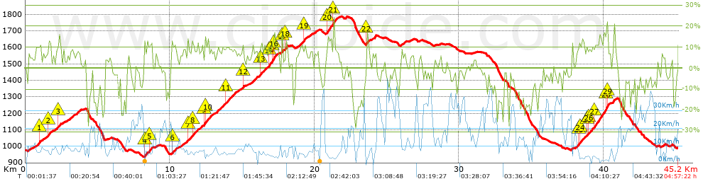
Distance in Km: 45.24
Climb in m: 1729
IBP: 129 BYC

Joxe_Marin
Author: Joxe_Marin
278 published routes

Add to my Group or Club

 Height in m      Climb in %      Speed in Km/h      Speed < 2 Km/h

Climbs > 5%

Climbs >5% Climbs >10% Climbs >15% Climbs >20% Climbs >25%
 Steep slope of 112 m.   Average slope  Distances  Download as waypoint
1
 Km 0.206  7%  112 m
 Steep slope of 519 m.  Average slope  Distances  Download as waypoint
2
 Km 0.745  10%  213 m
3
 Km 0.958  11%  112 m
4
 Km 1.07  6%  194 m
 Steep slope of 412 m.  Average slope  Distances  Download as waypoint
5
 Km 1.371  7%  236 m
6
 Km 1.607  12%  176 m
 Steep slope of 506 m.  Average slope  Distances  Download as waypoint
7
 Km 1.886  6%  358 m
8
 Km 2.243  12%  148 m
 Steep slope of 121 m.  Average slope  Distances  Download as waypoint
9
 Km 2.571  7%  121 m
 Steep slope of 443 m.  Average slope  Distances  Download as waypoint
10
 Km 2.894  7%  443 m
 Steep slope of 359 m.  Average slope  Distances  Download as waypoint
11
 Km 3.472  8%  359 m
 Steep slope of 532 m.  Average slope  Distances  Download as waypoint
12
 Km 8.214  12%  117 m
13
 Km 8.331  8%  247 m
14
 Km 8.578  12%  168 m
 Steep slope of 134 m.  Average slope  Distances  Download as waypoint
15
 Km 9.014  5%  134 m
 Steep slope of 283 m.  Average slope  Distances  Download as waypoint
16
 Km 10.149  11%  173 m
17
 Km 10.323  9%  110 m
 Steep slope of 286 m.  Average slope  Distances  Download as waypoint
18
 Km 10.597  6%  286 m
 Steep slope of 2012 m.  Average slope  Distances  Download as waypoint
19
 Km 11.037  8%  205 m
20
 Km 11.242  11%  111 m
21
 Km 11.353  9%  165 m
22
 Km 11.518  10%  146 m
23
 Km 11.664  8%  549 m
24
 Km 12.212  7%  138 m
25
 Km 12.35  13%  64 m
26
 Km 12.414  11%  97 m
27
 Km 12.511  12%  161 m
28
 Km 12.672  8%  376 m
 Steep slope of 1618 m.  Average slope  Distances  Download as waypoint
29
 Km 13.192  9%  684 m
30
 Km 13.876  10%  107 m
31
 Km 13.984  8%  827 m
 Steep slope of 173 m.  Average slope  Distances  Download as waypoint
32
 Km 14.924  6%  107 m
33
 Km 15.031  12%  66 m
 Steep slope of 1860 m.  Average slope  Distances  Download as waypoint
34
 Km 15.64  8%  674 m
35
 Km 16.314  11%  123 m
36
 Km 16.437  8%  380 m
37
 Km 16.817  12%  278 m
38
 Km 17.095  13%  107 m
39
 Km 17.203  12%  184 m
40
 Km 17.387  10%  114 m
 Steep slope of 142 m.  Average slope  Distances  Download as waypoint
41
 Km 17.683  6%  34 m
42
 Km 17.717  14%  108 m
 Steep slope of 175 m.  Average slope  Distances  Download as waypoint
43
 Km 17.997  15%  141 m
44
 Km 18.137  8%  34 m
 Steep slope of 1108 m.  Average slope  Distances  Download as waypoint
45
 Km 18.717  6%  309 m
46
 Km 19.027  8%  107 m
47
 Km 19.133  9%  141 m
48
 Km 19.274  13%  116 m
49
 Km 19.39  7%  435 m
 Steep slope of 295 m.  Average slope  Distances  Download as waypoint
50
 Km 20.014  7%  295 m
 Steep slope of 802 m.  Average slope  Distances  Download as waypoint
51
 Km 20.842  8%  36 m
52
 Km 20.878  14%  301 m
53
 Km 21.179  7%  103 m
54
 Km 21.282  19%  118 m
55
 Km 21.399  9%  74 m
56
 Km 21.473  8%  170 m
 Steep slope of 265 m.  Average slope  Distances  Download as waypoint
57
 Km 23.581  13%  145 m
58
 Km 23.727  7%  120 m
 Steep slope of 236 m.  Average slope  Distances  Download as waypoint
59
 Km 24.01  9%  236 m
 Steep slope of 324 m.  Average slope  Distances  Download as waypoint
60
 Km 25.98  7%  324 m
 Steep slope of 178 m.  Average slope  Distances  Download as waypoint
61
 Km 26.638  5%  178 m
 Steep slope of 2367 m.  Average slope  Distances  Download as waypoint
62
 Km 38.083  8%  105 m
63
 Km 38.188  8%  112 m
64
 Km 38.3  11%  113 m
65
 Km 38.412  12%  113 m
66
 Km 38.525  9%  300 m
67
 Km 38.825  10%  114 m
68
 Km 38.939  10%  414 m
69
 Km 39.353  13%  770 m
70
 Km 40.123  16%  148 m
71
 Km 40.271  24%  34 m
72
 Km 40.305  10%  144 m
 Steep slope of 257 m.  Average slope  Distances  Download as waypoint
73
 Km 40.63  10%  257 m
 Steep slope of 147 m.  Average slope  Distances  Download as waypoint
74
 Km 44.048  7%  147 m


Description of the route


Presence of ramps


 Climbs  Distance  % of the total  Speed  Your speed would be  Time  Your time would be
   15 - 30%  1.039  2.3  4.05  ?  0:15:24  ?
   10 - 15%  5.093  11.26  5.69  ?  0:53:45  ?
   5 - 10%  10.065  22.25  7.41  ?  1:21:29  ?
   1 - 5%  6.405  14.16  10.09  ?  0:38:06  ?
   Total*  22.602 Km  49.96 %  7.19 Km/h  ? Km/h    3:08:44 h  ? h  
 Flat
   1 - -1%  3.897 Km  8.61 %  15.94 Km/h  ? Km/h    0:14:40 h  ? h  
 Descents
   -1 - -5%  6.264  13.85  20.52  ?  0:18:19  ?
   -5 - -10%  5.865  12.96  23.67  ?  0:14:52  ?
   -10 - -15%  2.761  6.1  15.17  ?  0:10:55  ?
   -15 - -30%  3.85  8.51  9.35  ?  0:24:42  ?
   Total*  18.739 Km  41.42 %  16.34 Km/h  ? Km/h    1:08:48 h  ? h  
* The total has not necessarily coincide with the sum of the partials after correction of errors

How long would it take you?

How long would it take you to cover this route?
There are routes without a valid time information, but with your average stats you can assess the possible duration

Joxe_Marin to cover this route you've need a time of:   4:32:12 h 
If you sign in and have a minimum of two tracks of this same modality, you can know your time for this route, calculated from your stats..


¿Cuanto consumirá tu E-BIKE?

Entra tu E-IBP (formato n,nn)

E-IBP :   X 129 = 


 Detected activity type =  ()
 Penalization due to track conditions: 61 %   ( > 50 % = MTB, < 50 % = RDB)
 Reliability of the track: A   (1728/90/0/-/-/90)
 Correction level applied to the track: 0
DIFFICULTY OF THE ROUTE
IBP = 129 BYC
According to your statistics
 Your time in motion would be: ? h
Your average speed would be: ? Km/h
 

 Total Distance: 45.24 Km
 Analysed distance: 45.24 Km
 Linear distance: 0 Km

 Cumulated positive ramps: 1728.8 m  list of points info
 Cumulated negative ramps: 1714.8 m
 Maximum height: 1785.8 m
 Minimum height: 931.8 m
 Climbing Ratio: 7.65 %
 Descent ratio: 9.15 %
 Cumulated postive ramps per Km: 38.21 m
 Cumulated negative ramps per Km: 37.9 m

 Total time: 4:57:22 h
 Time in movement: 4:32:12 h
 According to your statistics
 Your time in motion would be: ? h  
 Stopped time: 0:25:10 h
 Maximum slope filter: ~30 %
 Minimum separation analysed: ~30 m
 Number of points: 2471   (cad. 18.31 m)
 Significant waypoints: 1131   (cad. 40 m / 45.77 %)

 Changes in direction per Km: 10.3
 Changes in direction > 5º por Km: 7.16
 Cumulated straight stretches: 7.084 Km
 Straight stretches per Km: 156.59 m
 Penalized slope changes: 14
 Penalized slope changes per Km: 0.309

 Average speed in total: 9.13 Km/h
 Average speed while moving: 9.97 Km/h
 According to your statistics
 Your average speed would be: ? Km/h  
 Maximum sustained speed: 49.76 Km/h


Comments

You can be the first one in commenting this route

 
My comments
:
Add comment  (Registered users)
 
Notify me answers to my comment  Do not notify answers to my comment


Share this route with a friend

Your friend will receive a message with a link to this page:
will see your email and your user name if you do it as registered user.


Write here your name (optional)

E-mail address of your friend(s). You can include various addresses separated by commas

Text or comment (optional) maximum 255 characters long, 255 Available characters

As a non registered users you need to fill-in the captcha text.
  Change image
Type the image characters.
 
 Share with a friend


Visited history

Delete history

Marked routes for review later or compare

My favorites


  Notify anomaly in this route Share in Facebook