Requena.Road28.123FCM.3h04m.

Road
Road
Ref..: 464152
Published: 27/08/2018
Performed: 26/08/2018
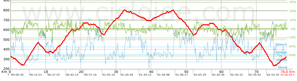
Distance in Km: 78.57
Climb in m: 1423
IBP: 85 BYC

Jorrupi_Chulilla
167 published routes

Add to my Group or Club

 Height in m      Climb in %      Speed in Km/h      Speed < 2 Km/h

Climbs > 5%

Climbs >5% Climbs >10% Climbs >15% Climbs >20% Climbs >25%
 Steep slope of 592 m.   Average slope  Distances  Download as waypoint
1
 Km 3.816  7%  592 m
 Steep slope of 129 m.  Average slope  Distances  Download as waypoint
2
 Km 4.608  5%  129 m
 Steep slope of 494 m.  Average slope  Distances  Download as waypoint
3
 Km 4.872  7%  494 m
 Steep slope of 306 m.  Average slope  Distances  Download as waypoint
4
 Km 5.552  7%  306 m
 Steep slope of 148 m.  Average slope  Distances  Download as waypoint
5
 Km 5.992  7%  148 m
 Steep slope of 275 m.  Average slope  Distances  Download as waypoint
6
 Km 6.306  7%  275 m
 Steep slope of 350 m.  Average slope  Distances  Download as waypoint
7
 Km 6.73  6%  350 m
 Steep slope of 287 m.  Average slope  Distances  Download as waypoint
8
 Km 7.479  6%  287 m
 Steep slope of 100 m.  Average slope  Distances  Download as waypoint
9
 Km 10.795  6%  100 m
 Steep slope of 282 m.  Average slope  Distances  Download as waypoint
10
 Km 12.242  5%  282 m
 Steep slope of 498 m.  Average slope  Distances  Download as waypoint
11
 Km 12.893  8%  498 m
 Steep slope of 230 m.  Average slope  Distances  Download as waypoint
12
 Km 14.495  5%  230 m
 Steep slope of 120 m.  Average slope  Distances  Download as waypoint
13
 Km 14.854  5%  120 m
 Steep slope of 615 m.  Average slope  Distances  Download as waypoint
14
 Km 15.23  8%  615 m
 Steep slope of 169 m.  Average slope  Distances  Download as waypoint
15
 Km 16.347  8%  169 m
 Steep slope of 108 m.  Average slope  Distances  Download as waypoint
16
 Km 16.628  7%  108 m
 Steep slope of 101 m.  Average slope  Distances  Download as waypoint
17
 Km 17  8%  101 m
 Steep slope of 181 m.  Average slope  Distances  Download as waypoint
18
 Km 17.322  7%  181 m
 Steep slope of 118 m.  Average slope  Distances  Download as waypoint
19
 Km 18.386  6%  118 m
 Steep slope of 388 m.  Average slope  Distances  Download as waypoint
20
 Km 19.594  8%  388 m
 Steep slope of 163 m.  Average slope  Distances  Download as waypoint
21
 Km 20.221  5%  163 m
 Steep slope of 132 m.  Average slope  Distances  Download as waypoint
22
 Km 20.807  6%  132 m
 Steep slope of 409 m.  Average slope  Distances  Download as waypoint
23
 Km 26.732  7%  409 m
 Steep slope of 307 m.  Average slope  Distances  Download as waypoint
24
 Km 27.36  6%  307 m
 Steep slope of 393 m.  Average slope  Distances  Download as waypoint
25
 Km 27.844  6%  393 m
 Steep slope of 422 m.  Average slope  Distances  Download as waypoint
26
 Km 28.571  6%  422 m
 Steep slope of 230 m.  Average slope  Distances  Download as waypoint
27
 Km 29.824  6%  230 m
 Steep slope of 288 m.  Average slope  Distances  Download as waypoint
28
 Km 30.629  6%  288 m
 Steep slope of 290 m.  Average slope  Distances  Download as waypoint
29
 Km 31.269  7%  290 m
 Steep slope of 497 m.  Average slope  Distances  Download as waypoint
30
 Km 31.787  6%  497 m
 Steep slope of 114 m.  Average slope  Distances  Download as waypoint
31
 Km 40.446  5%  114 m
 Steep slope of 222 m.  Average slope  Distances  Download as waypoint
32
 Km 44.299  6%  222 m
 Steep slope of 817 m.  Average slope  Distances  Download as waypoint
33
 Km 52.774  8%  817 m
 Steep slope of 162 m.  Average slope  Distances  Download as waypoint
34
 Km 53.864  6%  162 m
 Steep slope of 154 m.  Average slope  Distances  Download as waypoint
35
 Km 56.542  6%  154 m
 Steep slope of 116 m.  Average slope  Distances  Download as waypoint
36
 Km 66.701  5%  116 m
 Steep slope of 455 m.  Average slope  Distances  Download as waypoint
37
 Km 68.727  7%  455 m
 Steep slope of 146 m.  Average slope  Distances  Download as waypoint
38
 Km 69.488  6%  146 m
 Steep slope of 164 m.  Average slope  Distances  Download as waypoint
39
 Km 70.468  5%  164 m
 Steep slope of 163 m.  Average slope  Distances  Download as waypoint
40
 Km 75.626  6%  163 m
 Steep slope of 121 m.  Average slope  Distances  Download as waypoint
41
 Km 77.181  7%  121 m
 Steep slope of 134 m.  Average slope  Distances  Download as waypoint
42
 Km 77.816  6%  134 m


Description of the route


Presence of ramps


 Climbs  Distance  % of the total  Speed  Your speed would be  Time  Your time would be
   15 - 30%  0  0  0  ?  0:00:00  ?
   10 - 15%  0.348  0.44  15.66  ?  0:01:20  ?
   5 - 10%  13.046  16.61  16.2  ?  0:48:20  ?
   1 - 5%  18.065  22.99  20  ?  0:54:12  ?
   Total*  31.46 Km  40.04 %  18.17 Km/h  ? Km/h    1:43:52 h  ? h  
 Flat
   1 - -1%  15.615 Km  19.87 %  28.56 Km/h  ? Km/h    0:32:48 h  ? h  
 Descents
   -1 - -5%  18.561  23.63  37.35  ?  0:29:49  ?
   -5 - -10%  12.164  15.48  44.01  ?  0:16:35  ?
   -10 - -15%  0.767  0.98  46  ?  0:01:00  ?
   -15 - -30%  0  0  0  ?  0:00:00  ?
   Total*  31.492 Km  40.08 %  39.86 Km/h  ? Km/h    0:47:24 h  ? h  
* The total has not necessarily coincide with the sum of the partials after correction of errors

How long would it take you?

How long would it take you to cover this route?
There are routes without a valid time information, but with your average stats you can assess the possible duration

Jorrupi_Chulilla to cover this route you've need a time of:   3:04:04 h 
If you sign in and have a minimum of two tracks of this same modality, you can know your time for this route, calculated from your stats..


¿Cuanto consumirá tu E-BIKE?

Entra tu E-IBP (formato n,nn)

E-IBP :   X 85 = 


 Detected activity type =  ()
 Penalization due to track conditions: 47 %   ( > 50 % = MTB, < 50 % = RDB)
 Reliability of the track: A   (1421/78/0/-/-/78)
 Correction level applied to the track: 0
DIFFICULTY OF THE ROUTE
IBP = 85 BYC
According to your statistics
 Your time in motion would be: ? h
Your average speed would be: ? Km/h
 

 Total Distance: 78.57 Km
 Analysed distance: 78.57 Km
 Linear distance: 0.02 Km

 Cumulated positive ramps: 1423.2 m  list of points info
 Cumulated negative ramps: 1426 m
 Maximum height: 805 m
 Minimum height: 233 m
 Climbing Ratio: 4.52 %
 Descent ratio: 4.53 %
 Cumulated postive ramps per Km: 18.11 m
 Cumulated negative ramps per Km: 18.15 m

 Total time: 3:06:09 h
 Time in movement: 3:04:04 h
 According to your statistics
 Your time in motion would be: ? h  
 Stopped time: 0:02:05 h
 Maximum slope filter: ~30 %
 Minimum separation analysed: ~30 m
 Number of points: 3132   (cad. 25.09 m)
 Significant waypoints: 1742   (cad. 45.1 m / 55.62 %)

 Changes in direction per Km: 7.57
 Changes in direction > 5º por Km: 5.61
 Cumulated straight stretches: 18.146 Km
 Straight stretches per Km: 230.95 m
 Penalized slope changes: 13
 Penalized slope changes per Km: 0.165

 Average speed in total: 25.32 Km/h
 Average speed while moving: 25.61 Km/h
 According to your statistics
 Your average speed would be: ? Km/h  
 Maximum sustained speed: 68.29 Km/h


Comments

You can be the first one in commenting this route

 
My comments
:
Add comment  (Registered users)
 
Notify me answers to my comment  Do not notify answers to my comment


Share this route with a friend

Your friend will receive a message with a link to this page:
will see your email and your user name if you do it as registered user.


Write here your name (optional)

E-mail address of your friend(s). You can include various addresses separated by commas

Text or comment (optional) maximum 255 characters long, 255 Available characters

As a non registered users you need to fill-in the captcha text.
  Change image
Type the image characters.
 
 Share with a friend


Visited history

Delete history

Marked routes for review later or compare

My favorites


  Notify anomaly in this route Share in Facebook