Pulsometro Track_. ruton con el BRO (respect) y chema.Gran salida!!!seguimos sumando/disfrutando/apr...

Road
Road
Ref..: 451087
Published: 12/08/2018
Performed: 11/08/2018
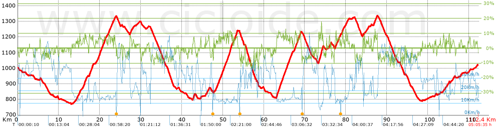
Distance in Km: 112.43
Climb in m: 2437
IBP: 152 BYC


 Height in m      Climb in %      Speed in Km/h      Speed < 2 Km/h

Climbs > 5%

Climbs >5% Climbs >10% Climbs >15% Climbs >20% Climbs >25%
 Steep slope of 215 m.   Average slope  Distances  Download as waypoint
1
 Km 14.249  6%  215 m
 Steep slope of 157 m.  Average slope  Distances  Download as waypoint
2
 Km 14.58  7%  157 m
 Steep slope of 419 m.  Average slope  Distances  Download as waypoint
3
 Km 14.865  6%  419 m
 Steep slope of 878 m.  Average slope  Distances  Download as waypoint
4
 Km 15.935  7%  878 m
 Steep slope of 1001 m.  Average slope  Distances  Download as waypoint
5
 Km 17.429  8%  1001 m
 Steep slope of 110 m.  Average slope  Distances  Download as waypoint
6
 Km 18.996  5%  110 m
 Steep slope of 120 m.  Average slope  Distances  Download as waypoint
7
 Km 19.257  5%  120 m
 Steep slope of 1116 m.  Average slope  Distances  Download as waypoint
8
 Km 19.56  7%  1116 m
 Steep slope of 230 m.  Average slope  Distances  Download as waypoint
9
 Km 20.78  7%  230 m
 Steep slope of 376 m.  Average slope  Distances  Download as waypoint
10
 Km 21.124  7%  376 m
 Steep slope of 430 m.  Average slope  Distances  Download as waypoint
11
 Km 21.996  7%  430 m
 Steep slope of 674 m.  Average slope  Distances  Download as waypoint
12
 Km 22.566  7%  674 m
 Steep slope of 273 m.  Average slope  Distances  Download as waypoint
13
 Km 23.357  6%  273 m
 Steep slope of 409 m.  Average slope  Distances  Download as waypoint
14
 Km 27.347  7%  409 m
 Steep slope of 101 m.  Average slope  Distances  Download as waypoint
15
 Km 28.077  5%  101 m
 Steep slope of 376 m.  Average slope  Distances  Download as waypoint
16
 Km 42.707  7%  376 m
 Steep slope of 175 m.  Average slope  Distances  Download as waypoint
17
 Km 44.553  7%  175 m
 Steep slope of 116 m.  Average slope  Distances  Download as waypoint
18
 Km 45.773  5%  116 m
 Steep slope of 181 m.  Average slope  Distances  Download as waypoint
19
 Km 46.174  6%  181 m
 Steep slope of 125 m.  Average slope  Distances  Download as waypoint
20
 Km 46.519  6%  125 m
 Steep slope of 374 m.  Average slope  Distances  Download as waypoint
21
 Km 48.253  7%  374 m
 Steep slope of 376 m.  Average slope  Distances  Download as waypoint
22
 Km 48.751  7%  376 m
 Steep slope of 185 m.  Average slope  Distances  Download as waypoint
23
 Km 49.276  7%  185 m
 Steep slope of 1131 m.  Average slope  Distances  Download as waypoint
24
 Km 49.566  7%  1131 m
 Steep slope of 557 m.  Average slope  Distances  Download as waypoint
25
 Km 50.812  7%  557 m
 Steep slope of 990 m.  Average slope  Distances  Download as waypoint
26
 Km 51.48  8%  232 m
27
 Km 51.711  11%  221 m
28
 Km 51.932  7%  537 m
 Steep slope of 143 m.  Average slope  Distances  Download as waypoint
29
 Km 52.586  6%  143 m
 Steep slope of 712 m.  Average slope  Distances  Download as waypoint
30
 Km 52.836  7%  463 m
31
 Km 53.299  10%  123 m
32
 Km 53.422  8%  126 m
 Steep slope of 1238 m.  Average slope  Distances  Download as waypoint
33
 Km 63.063  8%  1238 m
 Steep slope of 1294 m.  Average slope  Distances  Download as waypoint
34
 Km 64.446  7%  1294 m
 Steep slope of 1024 m.  Average slope  Distances  Download as waypoint
35
 Km 65.846  7%  1024 m
 Steep slope of 138 m.  Average slope  Distances  Download as waypoint
36
 Km 66.968  5%  138 m
 Steep slope of 689 m.  Average slope  Distances  Download as waypoint
37
 Km 67.382  7%  689 m
 Steep slope of 918 m.  Average slope  Distances  Download as waypoint
38
 Km 68.169  7%  918 m
 Steep slope of 1218 m.  Average slope  Distances  Download as waypoint
39
 Km 73.343  9%  273 m
40
 Km 73.616  10%  104 m
41
 Km 73.72  9%  146 m
42
 Km 73.866  12%  223 m
43
 Km 74.089  8%  472 m
 Steep slope of 182 m.  Average slope  Distances  Download as waypoint
44
 Km 75.902  7%  182 m
 Steep slope of 166 m.  Average slope  Distances  Download as waypoint
45
 Km 76.206  6%  166 m
 Steep slope of 308 m.  Average slope  Distances  Download as waypoint
46
 Km 77.376  8%  308 m
 Steep slope of 148 m.  Average slope  Distances  Download as waypoint
47
 Km 77.788  7%  148 m
 Steep slope of 482 m.  Average slope  Distances  Download as waypoint
48
 Km 78.035  7%  482 m
 Steep slope of 100 m.  Average slope  Distances  Download as waypoint
49
 Km 78.684  8%  100 m
 Steep slope of 412 m.  Average slope  Distances  Download as waypoint
50
 Km 79.094  7%  412 m
 Steep slope of 112 m.  Average slope  Distances  Download as waypoint
51
 Km 79.947  7%  112 m
 Steep slope of 227 m.  Average slope  Distances  Download as waypoint
52
 Km 80.201  6%  227 m
 Steep slope of 150 m.  Average slope  Distances  Download as waypoint
53
 Km 84.163  9%  150 m
 Steep slope of 152 m.  Average slope  Distances  Download as waypoint
54
 Km 84.493  6%  152 m
 Steep slope of 98 m.  Average slope  Distances  Download as waypoint
55
 Km 85.306  5%  98 m
 Steep slope of 108 m.  Average slope  Distances  Download as waypoint
56
 Km 86.127  6%  108 m
 Steep slope of 461 m.  Average slope  Distances  Download as waypoint
57
 Km 86.778  7%  461 m
 Steep slope of 297 m.  Average slope  Distances  Download as waypoint
58
 Km 87.335  6%  297 m
 Steep slope of 221 m.  Average slope  Distances  Download as waypoint
59
 Km 101.709  5%  221 m
 Steep slope of 105 m.  Average slope  Distances  Download as waypoint
60
 Km 102.988  7%  105 m
 Steep slope of 169 m.  Average slope  Distances  Download as waypoint
61
 Km 103.845  5%  169 m
 Steep slope of 143 m.  Average slope  Distances  Download as waypoint
62
 Km 104.512  5%  143 m
 Steep slope of 102 m.  Average slope  Distances  Download as waypoint
63
 Km 105.149  11%  102 m
 Steep slope of 251 m.  Average slope  Distances  Download as waypoint
64
 Km 106.104  5%  251 m
 Steep slope of 143 m.  Average slope  Distances  Download as waypoint
65
 Km 107.962  5%  143 m


Description of the route


Presence of ramps


 Climbs  Distance  % of the total  Speed  Your speed would be  Time  Your time would be
   15 - 30%  0.038  0.03  8.64  ?  0:00:16  ?
   10 - 15%  2.891  2.57  12.47  ?  0:13:55  ?
   5 - 10%  22.209  19.75  14.86  ?  1:29:40  ?
   1 - 5%  18.534  16.49  20.08  ?  0:55:23  ?
   Total*  43.673 Km  38.85 %  16.46 Km/h  ? Km/h    2:39:14 h  ? h  
 Flat
   1 - -1%  23.717 Km  21.1 %  28.92 Km/h  ? Km/h    0:49:12 h  ? h  
 Descents
   -1 - -5%  21.038  18.71  39.36  ?  0:32:04  ?
   -5 - -10%  21.582  19.2  43.14  ?  0:30:01  ?
   -10 - -15%  2.283  2.03  39.14  ?  0:03:30  ?
   -15 - -30%  0.134  0.12  28.36  ?  0:00:17  ?
   Total*  45.037 Km  40.06 %  41.03 Km/h  ? Km/h    1:05:52 h  ? h  
* The total has not necessarily coincide with the sum of the partials after correction of errors

How long would it take you?

How long would it take you to cover this route?
There are routes without a valid time information, but with your average stats you can assess the possible duration

Ivan_Fuentes_Penya_Ciclista_Lloret/BTT_chivos to cover this route you've need a time of:   4:34:18 h 
If you sign in and have a minimum of two tracks of this same modality, you can know your time for this route, calculated from your stats..


¿Cuanto consumirá tu E-BIKE?

Entra tu E-IBP (formato n,nn)

E-IBP :   X 152 = 


 Detected activity type =  ()
 Penalization due to track conditions: 45 %   ( > 50 % = MTB, < 50 % = RDB)
 Reliability of the track: A   (2437/95/0/-/-/95)
 Correction level applied to the track: 0
DIFFICULTY OF THE ROUTE
IBP = 152 BYC
According to your statistics
 Your time in motion would be: ? h
Your average speed would be: ? Km/h
 

 Total Distance: 112.43 Km
 Analysed distance: 112.43 Km
 Linear distance: 0.22 Km

 Cumulated positive ramps: 2437 m  list of points info
 Cumulated negative ramps: 2422 m
 Maximum height: 1334.8 m
 Minimum height: 770.8 m
 Climbing Ratio: 5.58 %
 Descent ratio: 5.38 %
 Cumulated postive ramps per Km: 21.68 m
 Cumulated negative ramps per Km: 21.54 m

 Total time: 5:05:35 h
 Time in movement: 4:34:18 h
 According to your statistics
 Your time in motion would be: ? h  
 Stopped time: 0:31:17 h
 Maximum slope filter: ~30 %
 Minimum separation analysed: ~30 m
 Number of points: 6494   (cad. 17.31 m)
 Significant waypoints: 2943   (cad. 38.2 m / 45.32 %)

 Changes in direction per Km: 8.23
 Changes in direction > 5º por Km: 4.47
 Cumulated straight stretches: 38.68 Km
 Straight stretches per Km: 344.04 m
 Penalized slope changes: 19
 Penalized slope changes per Km: 0.169

 Average speed in total: 22.07 Km/h
 Average speed while moving: 24.59 Km/h
 According to your statistics
 Your average speed would be: ? Km/h  
 Maximum sustained speed: 65.7 Km/h


Comments

You can be the first one in commenting this route

 
My comments
:
Add comment  (Registered users)
 
Notify me answers to my comment  Do not notify answers to my comment


Share this route with a friend

Your friend will receive a message with a link to this page:
will see your email and your user name if you do it as registered user.


Write here your name (optional)

E-mail address of your friend(s). You can include various addresses separated by commas

Text or comment (optional) maximum 255 characters long, 255 Available characters

As a non registered users you need to fill-in the captcha text.
  Change image
Type the image characters.
 
 Share with a friend


Visited history

Delete history

Marked routes for review later or compare

My favorites


  Notify anomaly in this route Share in Facebook