Road: Circuto _ocho extrem_

Road
Road
Ref..: 450728
Published: 12/08/2018
Performed: 11/08/2018
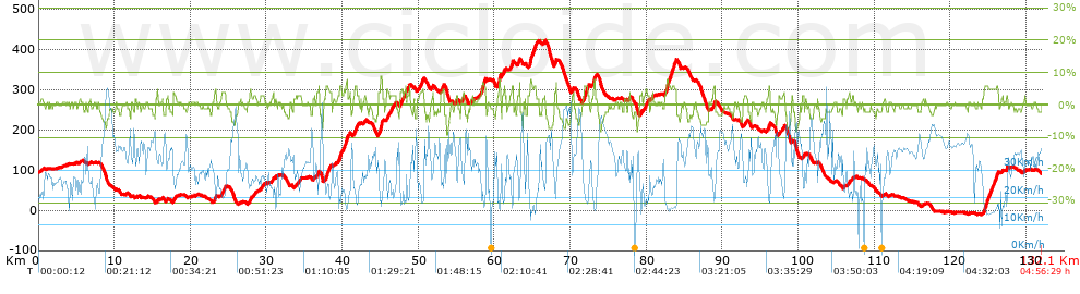
Distance in Km: 132.08
Climb in m: 1391
IBP: 107 BYC

Jose_Ortiz
Author: Jose_Ortiz
229 published routes

Add to my Group or Club

 Height in m      Climb in %      Speed in Km/h      Speed < 2 Km/h

Climbs > 5%

Climbs >5% Climbs >10% Climbs >15% Climbs >20% Climbs >25%
 Steep slope of 259 m.   Average slope  Distances  Download as waypoint
1
 Km 37.835  6%  259 m
 Steep slope of 250 m.  Average slope  Distances  Download as waypoint
2
 Km 39.619  6%  250 m
 Steep slope of 305 m.  Average slope  Distances  Download as waypoint
3
 Km 40.415  7%  305 m
 Steep slope of 264 m.  Average slope  Distances  Download as waypoint
4
 Km 41.649  6%  264 m
 Steep slope of 307 m.  Average slope  Distances  Download as waypoint
5
 Km 44.962  8%  307 m
 Steep slope of 135 m.  Average slope  Distances  Download as waypoint
6
 Km 47.823  5%  135 m
 Steep slope of 465 m.  Average slope  Distances  Download as waypoint
7
 Km 58.36  7%  465 m
 Steep slope of 237 m.  Average slope  Distances  Download as waypoint
8
 Km 60.602  8%  237 m
 Steep slope of 104 m.  Average slope  Distances  Download as waypoint
9
 Km 61.264  6%  104 m
 Steep slope of 198 m.  Average slope  Distances  Download as waypoint
10
 Km 62.282  6%  198 m
 Steep slope of 256 m.  Average slope  Distances  Download as waypoint
11
 Km 64.708  8%  256 m
 Steep slope of 273 m.  Average slope  Distances  Download as waypoint
12
 Km 65.209  6%  273 m
 Steep slope of 516 m.  Average slope  Distances  Download as waypoint
13
 Km 71.821  6%  516 m
 Steep slope of 217 m.  Average slope  Distances  Download as waypoint
14
 Km 73.052  8%  217 m
 Steep slope of 1297 m.  Average slope  Distances  Download as waypoint
15
 Km 82.659  6%  1297 m
 Steep slope of 210 m.  Average slope  Distances  Download as waypoint
16
 Km 88.855  6%  210 m
 Steep slope of 237 m.  Average slope  Distances  Download as waypoint
17
 Km 96.067  6%  237 m
 Steep slope of 541 m.  Average slope  Distances  Download as waypoint
18
 Km 124.473  6%  541 m
 Steep slope of 258 m.  Average slope  Distances  Download as waypoint
19
 Km 126.022  6%  258 m


Description of the route


Presence of ramps


 Climbs  Distance  % of the total  Speed  Your speed would be  Time  Your time would be
   15 - 30%  0  0  0  ?  0:00:00  ?
   10 - 15%  0  0  0  ?  0:00:00  ?
   5 - 10%  6.867  5.2  18.83  ?  0:21:53  ?
   1 - 5%  36.741  27.82  25.05  ?  1:28:00  ?
   Total*  43.608 Km  33.02 %  23.81 Km/h  ? Km/h    1:49:53 h  ? h  
 Flat
   1 - -1%  41.423 Km  31.36 %  31.02 Km/h  ? Km/h    1:20:07 h  ? h  
 Descents
   -1 - -5%  40.752  30.85  36.88  ?  1:06:18  ?
   -5 - -10%  6.339  4.8  44.31  ?  0:08:35  ?
   -10 - -15%  0  0  0  ?  0:00:00  ?
   -15 - -30%  0  0  0  ?  0:00:00  ?
   Total*  47.091 Km  35.65 %  37.73 Km/h  ? Km/h    1:14:53 h  ? h  
* The total has not necessarily coincide with the sum of the partials after correction of errors

How long would it take you?

How long would it take you to cover this route?
There are routes without a valid time information, but with your average stats you can assess the possible duration

Jose_Ortiz to cover this route you've need a time of:   4:24:53 h 
If you sign in and have a minimum of two tracks of this same modality, you can know your time for this route, calculated from your stats..


¿Cuanto consumirá tu E-BIKE?

Entra tu E-IBP (formato n,nn)

E-IBP :   X 107 = 


 Detected activity type =  ()
 Penalization due to track conditions: 31 %   ( > 50 % = MTB, < 50 % = RDB)
 Reliability of the track: D   (1788/41/1/3/-/69)
 Correction level applied to the track: 4        See analyis without corrections
DIFFICULTY OF THE ROUTE
IBP = 107 BYC
According to your statistics
 Your time in motion would be: ? h
Your average speed would be: ? Km/h
 

 Total Distance: 132.08 Km
 Analysed distance: 132.08 Km
 Linear distance: 0.02 Km

 Cumulated positive ramps: 1391.04 m  list of points info
 Cumulated negative ramps: 1402.8 m
 Maximum height: 422.81 m
 Minimum height: -10.53 m
 Climbing Ratio: 3.19 %
 Descent ratio: 2.98 %
 Cumulated postive ramps per Km: 10.53 m
 Cumulated negative ramps per Km: 10.62 m

 Total time: 4:56:29 h
 Time in movement: 4:24:53 h
 According to your statistics
 Your time in motion would be: ? h  
 Stopped time: 0:31:36 h
 Maximum slope filter: ~30 %
 Minimum separation analysed: ~30 m
 Number of points: 8281   (cad. 15.95 m)
 Significant waypoints: 3567   (cad. 37.04 m / 43.07 %)

 Changes in direction per Km: 7.75
 Changes in direction > 5º por Km: 3.97
 Cumulated straight stretches: 61.456 Km
 Straight stretches per Km: 465.29 m
 Penalized slope changes: 16
 Penalized slope changes per Km: 0.121

 Average speed in total: 26.73 Km/h
 Average speed while moving: 29.92 Km/h
 According to your statistics
 Your average speed would be: ? Km/h  
 Maximum sustained speed: 61.89 Km/h


Comments

You can be the first one in commenting this route

 
My comments
:
Add comment  (Registered users)
 
Notify me answers to my comment  Do not notify answers to my comment


Share this route with a friend

Your friend will receive a message with a link to this page:
will see your email and your user name if you do it as registered user.


Write here your name (optional)

E-mail address of your friend(s). You can include various addresses separated by commas

Text or comment (optional) maximum 255 characters long, 255 Available characters

As a non registered users you need to fill-in the captcha text.
  Change image
Type the image characters.
 
 Share with a friend


Visited history

Delete history

Marked routes for review later or compare

My favorites


  Notify anomaly in this route Share in Facebook