180707 Salida Carretera

Road
Road
Ref..: 427354
Published: 09/07/2018
Performed: 07/07/2018
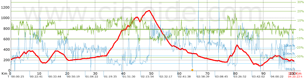
Distance in Km: 101.03
Climb in m: 2225
IBP: 163 BYC

Near ...
Abuli, Ajuyan, Arquera, La (Oviedo), Atrollo, El, Ayones (Oviedo), Belonga
Olbap_AG
Author: Olbap_AG
358 published routes

Add to my Group or Club

 Height in m      Climb in %      Speed in Km/h      Speed < 2 Km/h

Climbs > 5%

Climbs >5% Climbs >10% Climbs >15% Climbs >20% Climbs >25%
 Steep slope of 131 m.   Average slope  Distances  Download as waypoint
1
 Km 0.268  7%  131 m
 Steep slope of 1403 m.  Average slope  Distances  Download as waypoint
2
 Km 3.125  7%  1403 m
 Steep slope of 317 m.  Average slope  Distances  Download as waypoint
3
 Km 5.442  8%  317 m
 Steep slope of 283 m.  Average slope  Distances  Download as waypoint
4
 Km 5.862  6%  283 m
 Steep slope of 137 m.  Average slope  Distances  Download as waypoint
5
 Km 12.973  8%  137 m
 Steep slope of 2134 m.  Average slope  Distances  Download as waypoint
6
 Km 13.283  7%  2134 m
 Steep slope of 335 m.  Average slope  Distances  Download as waypoint
7
 Km 15.517  6%  335 m
 Steep slope of 109 m.  Average slope  Distances  Download as waypoint
8
 Km 30.2  7%  109 m
 Steep slope of 1091 m.  Average slope  Distances  Download as waypoint
9
 Km 34.062  8%  182 m
10
 Km 34.244  11%  183 m
11
 Km 34.426  9%  726 m
 Steep slope of 401 m.  Average slope  Distances  Download as waypoint
12
 Km 35.269  7%  401 m
 Steep slope of 203 m.  Average slope  Distances  Download as waypoint
13
 Km 35.783  5%  203 m
 Steep slope of 1316 m.  Average slope  Distances  Download as waypoint
14
 Km 36.097  8%  112 m
15
 Km 36.209  12%  392 m
16
 Km 36.601  10%  189 m
17
 Km 36.79  10%  107 m
18
 Km 36.896  6%  516 m
 Steep slope of 217 m.  Average slope  Distances  Download as waypoint
19
 Km 37.509  5%  217 m
 Steep slope of 1635 m.  Average slope  Distances  Download as waypoint
20
 Km 37.855  10%  142 m
21
 Km 37.997  11%  100 m
22
 Km 38.098  11%  140 m
23
 Km 38.238  11%  102 m
24
 Km 38.34  12%  888 m
25
 Km 39.228  12%  109 m
26
 Km 39.337  12%  117 m
27
 Km 39.454  9%  37 m
 Steep slope of 109 m.  Average slope  Distances  Download as waypoint
28
 Km 39.886  5%  109 m
 Steep slope of 833 m.  Average slope  Distances  Download as waypoint
29
 Km 40.844  7%  220 m
30
 Km 41.064  12%  322 m
31
 Km 41.385  11%  109 m
32
 Km 41.494  11%  102 m
33
 Km 41.597  9%  80 m
 Steep slope of 178 m.  Average slope  Distances  Download as waypoint
34
 Km 42.203  10%  178 m
 Steep slope of 179 m.  Average slope  Distances  Download as waypoint
35
 Km 42.486  11%  116 m
36
 Km 42.602  7%  63 m
 Steep slope of 714 m.  Average slope  Distances  Download as waypoint
37
 Km 42.791  15%  38 m
38
 Km 42.829  16%  100 m
39
 Km 42.928  9%  142 m
40
 Km 43.07  9%  434 m
 Steep slope of 184 m.  Average slope  Distances  Download as waypoint
41
 Km 43.634  8%  184 m
 Steep slope of 246 m.  Average slope  Distances  Download as waypoint
42
 Km 43.929  6%  74 m
43
 Km 44.003  12%  101 m
44
 Km 44.104  8%  71 m
 Steep slope of 1072 m.  Average slope  Distances  Download as waypoint
45
 Km 46.007  12%  592 m
46
 Km 46.599  10%  261 m
47
 Km 46.861  10%  106 m
48
 Km 46.967  6%  113 m
 Steep slope of 870 m.  Average slope  Distances  Download as waypoint
49
 Km 47.252  7%  870 m
 Steep slope of 250 m.  Average slope  Distances  Download as waypoint
50
 Km 60.619  6%  250 m
 Steep slope of 1050 m.  Average slope  Distances  Download as waypoint
51
 Km 77.163  12%  785 m
52
 Km 77.948  10%  265 m
 Steep slope of 1710 m.  Average slope  Distances  Download as waypoint
53
 Km 78.774  6%  75 m
54
 Km 78.849  11%  305 m
55
 Km 79.154  7%  186 m
56
 Km 79.34  12%  113 m
57
 Km 79.454  8%  133 m
58
 Km 79.587  11%  149 m
59
 Km 79.735  17%  349 m
60
 Km 80.084  14%  124 m
61
 Km 80.208  10%  108 m
62
 Km 80.317  12%  168 m
 Steep slope of 275 m.  Average slope  Distances  Download as waypoint
63
 Km 89.684  7%  275 m
 Steep slope of 229 m.  Average slope  Distances  Download as waypoint
64
 Km 90.232  6%  229 m
 Steep slope of 365 m.  Average slope  Distances  Download as waypoint
65
 Km 91.322  6%  365 m
 Steep slope of 278 m.  Average slope  Distances  Download as waypoint
66
 Km 91.79  7%  278 m
 Steep slope of 321 m.  Average slope  Distances  Download as waypoint
67
 Km 93.15  7%  321 m
 Steep slope of 117 m.  Average slope  Distances  Download as waypoint
68
 Km 93.644  5%  117 m
 Steep slope of 119 m.  Average slope  Distances  Download as waypoint
69
 Km 99.63  5%  119 m


Description of the route


Presence of ramps


 Climbs  Distance  % of the total  Speed  Your speed would be  Time  Your time would be
   15 - 30%  0.669  0.66  8.67  ?  0:04:38  ?
   10 - 15%  5.805  5.75  10.63  ?  0:32:45  ?
   5 - 10%  14.245  14.1  15.24  ?  0:56:05  ?
   1 - 5%  13.382  13.25  21.34  ?  0:37:38  ?
   Total*  34.101 Km  33.75 %  15.61 Km/h  ? Km/h    2:11:06 h  ? h  
 Flat
   1 - -1%  29.843 Km  29.54 %  29.37 Km/h  ? Km/h    1:00:58 h  ? h  
 Descents
   -1 - -5%  14.789  14.64  35.45  ?  0:25:02  ?
   -5 - -10%  18.439  18.25  43.7  ?  0:25:19  ?
   -10 - -15%  3.774  3.74  45.59  ?  0:04:58  ?
   -15 - -30%  0.082  0.08  49.19  ?  0:00:06  ?
   Total*  37.084 Km  36.71 %  40.15 Km/h  ? Km/h    0:55:25 h  ? h  
* The total has not necessarily coincide with the sum of the partials after correction of errors

How long would it take you?

How long would it take you to cover this route?
There are routes without a valid time information, but with your average stats you can assess the possible duration

Olbap_AG to cover this route you've need a time of:   4:07:29 h 
If you sign in and have a minimum of two tracks of this same modality, you can know your time for this route, calculated from your stats..


¿Cuanto consumirá tu E-BIKE?

Entra tu E-IBP (formato n,nn)

E-IBP :   X 163 = 


 Detected activity type =  ()
 Penalization due to track conditions: 56 %   ( > 50 % = MTB, < 50 % = RDB)
 Reliability of the track: A   (2225/89/0/-/-/89)
 Correction level applied to the track: 0
DIFFICULTY OF THE ROUTE
IBP = 163 BYC
According to your statistics
 Your time in motion would be: ? h
Your average speed would be: ? Km/h
 

 Total Distance: 101.03 Km
 Analysed distance: 101.03 Km
 Linear distance: 0.59 Km

 Cumulated positive ramps: 2225.2 m  list of points info
 Cumulated negative ramps: 2235.43 m
 Maximum height: 1143.4 m
 Minimum height: 92.4 m
 Climbing Ratio: 6.53 %
 Descent ratio: 6.03 %
 Cumulated postive ramps per Km: 22.03 m
 Cumulated negative ramps per Km: 22.13 m

 Total time: 4:20:23 h
 Time in movement: 4:07:29 h
 According to your statistics
 Your time in motion would be: ? h  
 Stopped time: 0:12:54 h
 Maximum slope filter: ~30 %
 Minimum separation analysed: ~30 m
 Number of points: 5725   (cad. 17.65 m)
 Significant waypoints: 2510   (cad. 40.25 m / 43.84 %)

 Changes in direction per Km: 8.73
 Changes in direction > 5º por Km: 5.96
 Cumulated straight stretches: 21.768 Km
 Straight stretches per Km: 215.46 m
 Penalized slope changes: 17
 Penalized slope changes per Km: 0.168

 Average speed in total: 23.28 Km/h
 Average speed while moving: 24.49 Km/h
 According to your statistics
 Your average speed would be: ? Km/h  
 Maximum sustained speed: 71.89 Km/h


Comments

You can be the first one in commenting this route

 
My comments
:
Add comment  (Registered users)
 
Notify me answers to my comment  Do not notify answers to my comment


Share this route with a friend

Your friend will receive a message with a link to this page:
will see your email and your user name if you do it as registered user.


Write here your name (optional)

E-mail address of your friend(s). You can include various addresses separated by commas

Text or comment (optional) maximum 255 characters long, 255 Available characters

As a non registered users you need to fill-in the captcha text.
  Change image
Type the image characters.
 
 Share with a friend


Visited history

Delete history

Marked routes for review later or compare

My favorites


  Notify anomaly in this route Share in Facebook