Can Plana-Castell Montsoriu MTB

MTB
MTB
Ref..: 424134
Published: 04/07/2018
Performed: 30/06/2018
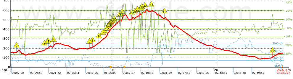
Distance in Km: 26.45
Climb in m: 949
IBP: 104 BYC

Xabemar
Author: Xabemar
17 published routes

Add to my Group or Club

 Height in m      Climb in %      Speed in Km/h      Speed < 2 Km/h

Climbs > 5%

Climbs >5% Climbs >10% Climbs >15% Climbs >20% Climbs >25%
 Steep slope of 136 m.   Average slope  Distances  Download as waypoint
1
 Km 0  10%  136 m
 Steep slope of 184 m.  Average slope  Distances  Download as waypoint
2
 Km 0.591  11%  184 m
 Steep slope of 224 m.  Average slope  Distances  Download as waypoint
3
 Km 3.223  7%  224 m
 Steep slope of 249 m.  Average slope  Distances  Download as waypoint
4
 Km 3.573  6%  138 m
5
 Km 3.711  11%  111 m
 Steep slope of 64 m.  Average slope  Distances  Download as waypoint
6
 Km 4.125  19%  64 m
 Steep slope of 110 m.  Average slope  Distances  Download as waypoint
7
 Km 7.702  8%  110 m
 Steep slope of 458 m.  Average slope  Distances  Download as waypoint
8
 Km 8.014  9%  458 m
 Steep slope of 529 m.  Average slope  Distances  Download as waypoint
9
 Km 8.582  9%  350 m
10
 Km 8.932  11%  179 m
 Steep slope of 1405 m.  Average slope  Distances  Download as waypoint
11
 Km 9.205  11%  136 m
12
 Km 9.341  28%  107 m
13
 Km 9.448  20%  42 m
14
 Km 9.49  17%  77 m
15
 Km 9.568  13%  106 m
16
 Km 9.674  15%  114 m
17
 Km 9.788  16%  34 m
18
 Km 9.821  7%  107 m
19
 Km 9.929  13%  115 m
20
 Km 10.044  9%  528 m
21
 Km 10.572  25%  39 m
 Steep slope of 206 m.  Average slope  Distances  Download as waypoint
22
 Km 10.772  24%  42 m
23
 Km 10.814  27%  164 m
 Steep slope of 200 m.  Average slope  Distances  Download as waypoint
24
 Km 11.701  6%  50 m
25
 Km 11.751  20%  150 m
 Steep slope of 281 m.  Average slope  Distances  Download as waypoint
26
 Km 12.07  6%  127 m
27
 Km 12.196  6%  116 m
28
 Km 12.312  14%  38 m
 Steep slope of 157 m.  Average slope  Distances  Download as waypoint
29
 Km 12.692  27%  116 m
30
 Km 12.808  20%  41 m
 Steep slope of 202 m.  Average slope  Distances  Download as waypoint
31
 Km 13.061  5%  35 m
32
 Km 13.096  17%  167 m
 Steep slope of 113 m.  Average slope  Distances  Download as waypoint
33
 Km 13.624  25%  113 m
 Steep slope of 139 m.  Average slope  Distances  Download as waypoint
34
 Km 14.907  12%  139 m
 Steep slope of 569 m.  Average slope  Distances  Download as waypoint
35
 Km 25.426  7%  569 m


Description of the route


Presence of ramps


 Climbs  Distance  % of the total  Speed  Your speed would be  Time  Your time would be
   15 - 30%  1.921  7.26  5.5  ?  0:20:58  ?
   10 - 15%  1.426  5.39  5.68  ?  0:15:04  ?
   5 - 10%  3.21  12.13  6.27  ?  0:30:44  ?
   1 - 5%  4.358  16.47  10.77  ?  0:24:16  ?
   Total*  10.914 Km  41.26 %  7.19 Km/h  ? Km/h    1:31:02 h  ? h  
 Flat
   1 - -1%  2.67 Km  10.09 %  16.1 Km/h  ? Km/h    0:09:57 h  ? h  
 Descents
   -1 - -5%  5.596  21.15  18.45  ?  0:18:12  ?
   -5 - -10%  4.823  18.23  19.96  ?  0:14:30  ?
   -10 - -15%  1.094  4.14  11.52  ?  0:05:42  ?
   -15 - -30%  1.37  5.18  12.58  ?  0:06:32  ?
   Total*  12.883 Km  48.7 %  17.2 Km/h  ? Km/h    0:44:56 h  ? h  
* The total has not necessarily coincide with the sum of the partials after correction of errors

How long would it take you?

How long would it take you to cover this route?
There are routes without a valid time information, but with your average stats you can assess the possible duration

Xabemar to cover this route you've need a time of:   2:25:55 h 
If you sign in and have a minimum of two tracks of this same modality, you can know your time for this route, calculated from your stats..


¿Cuanto consumirá tu E-BIKE?

Entra tu E-IBP (formato n,nn)

E-IBP :   X 104 = 


 Detected activity type =  ()
 Penalization due to track conditions: 82 %   ( > 50 % = MTB, < 50 % = RDB)
 Reliability of the track: B   (959/58/0/-/-/58)
 Correction level applied to the track: 0
DIFFICULTY OF THE ROUTE
IBP = 104 BYC
According to your statistics
 Your time in motion would be: ? h
Your average speed would be: ? Km/h
 

 Total Distance: 26.45 Km
 Analysed distance: 26.45 Km
 Linear distance: 0.03 Km

 Cumulated positive ramps: 949.15 m  list of points info
 Cumulated negative ramps: 945.75 m
 Maximum height: 611 m
 Minimum height: 87.4 m
 Climbing Ratio: 8.7 %
 Descent ratio: 7.34 %
 Cumulated postive ramps per Km: 35.88 m
 Cumulated negative ramps per Km: 35.76 m

 Total time: 3:08:35 h
 Time in movement: 2:25:55 h
 According to your statistics
 Your time in motion would be: ? h  
 Stopped time: 0:42:40 h
 Maximum slope filter: ~30 %
 Minimum separation analysed: ~30 m
 Number of points: 900   (cad. 29.39 m)
 Significant waypoints: 545   (cad. 48.63 m / 60.56 %)

 Changes in direction per Km: 8.96
 Changes in direction > 5º por Km: 7.52
 Cumulated straight stretches: 3.896 Km
 Straight stretches per Km: 147.3 m
 Penalized slope changes: 7
 Penalized slope changes per Km: 0.265

 Average speed in total: 8.42 Km/h
 Average speed while moving: 10.88 Km/h
 According to your statistics
 Your average speed would be: ? Km/h  
 Maximum sustained speed: 45.02 Km/h


Comments

You can be the first one in commenting this route

 
My comments
:
Add comment  (Registered users)
 
Notify me answers to my comment  Do not notify answers to my comment


Share this route with a friend

Your friend will receive a message with a link to this page:
will see your email and your user name if you do it as registered user.


Write here your name (optional)

E-mail address of your friend(s). You can include various addresses separated by commas

Text or comment (optional) maximum 255 characters long, 255 Available characters

As a non registered users you need to fill-in the captcha text.
  Change image
Type the image characters.
 
 Share with a friend


Visited history

Delete history

Marked routes for review later or compare

My favorites


  Notify anomaly in this route Share in Facebook