Salève du Pape

MTB
MTB
Ref..: 419163
Published: 26/06/2018
Performed: 21/06/2018
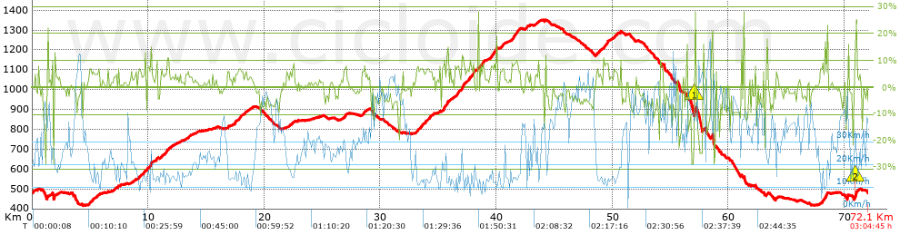
Distance in Km: 72.14
Climb in m: 1804
IBP: 124 BYC

de_gavroche
Author: de_gavroche
131 published routes

Add to my Group or Club

 Height in m      Climb in %      Speed in Km/h      Speed < 2 Km/h

Climbs > 5%

Climbs >5% Climbs >10% Climbs >15% Climbs >20% Climbs >25%
 Steep slope of 140 m.   Average slope  Distances  Download as waypoint
1
 Km 0.053  5%  140 m
 Steep slope of 343 m.  Average slope  Distances  Download as waypoint
2
 Km 4.893  6%  343 m
 Steep slope of 149 m.  Average slope  Distances  Download as waypoint
3
 Km 5.407  5%  149 m
 Steep slope of 142 m.  Average slope  Distances  Download as waypoint
4
 Km 5.698  6%  142 m
 Steep slope of 179 m.  Average slope  Distances  Download as waypoint
5
 Km 9.241  6%  179 m
 Steep slope of 228 m.  Average slope  Distances  Download as waypoint
6
 Km 9.57  7%  228 m
 Steep slope of 313 m.  Average slope  Distances  Download as waypoint
7
 Km 9.906  9%  313 m
 Steep slope of 155 m.  Average slope  Distances  Download as waypoint
8
 Km 10.651  10%  155 m
 Steep slope of 149 m.  Average slope  Distances  Download as waypoint
9
 Km 11.093  7%  149 m
 Steep slope of 403 m.  Average slope  Distances  Download as waypoint
10
 Km 11.394  5%  219 m
11
 Km 11.612  11%  147 m
12
 Km 11.76  6%  37 m
 Steep slope of 163 m.  Average slope  Distances  Download as waypoint
13
 Km 16.845  6%  163 m
 Steep slope of 361 m.  Average slope  Distances  Download as waypoint
14
 Km 17.455  7%  361 m
 Steep slope of 281 m.  Average slope  Distances  Download as waypoint
15
 Km 17.943  6%  281 m
 Steep slope of 226 m.  Average slope  Distances  Download as waypoint
16
 Km 18.347  5%  226 m
 Steep slope of 137 m.  Average slope  Distances  Download as waypoint
17
 Km 22.414  6%  137 m
 Steep slope of 274 m.  Average slope  Distances  Download as waypoint
18
 Km 26.846  8%  274 m
 Steep slope of 251 m.  Average slope  Distances  Download as waypoint
19
 Km 28.388  6%  251 m
 Steep slope of 1377 m.  Average slope  Distances  Download as waypoint
20
 Km 33.082  6%  1377 m
 Steep slope of 487 m.  Average slope  Distances  Download as waypoint
21
 Km 35.341  8%  146 m
22
 Km 35.487  10%  311 m
23
 Km 35.799  12%  30 m
 Steep slope of 550 m.  Average slope  Distances  Download as waypoint
24
 Km 36.256  6%  550 m
 Steep slope of 1113 m.  Average slope  Distances  Download as waypoint
25
 Km 36.986  8%  40 m
26
 Km 37.027  12%  141 m
27
 Km 37.168  8%  932 m
 Steep slope of 454 m.  Average slope  Distances  Download as waypoint
28
 Km 38.425  8%  454 m
 Steep slope of 573 m.  Average slope  Distances  Download as waypoint
29
 Km 39.513  9%  573 m
 Steep slope of 359 m.  Average slope  Distances  Download as waypoint
30
 Km 40.314  7%  359 m
 Steep slope of 734 m.  Average slope  Distances  Download as waypoint
31
 Km 41.316  8%  734 m
 Steep slope of 141 m.  Average slope  Distances  Download as waypoint
32
 Km 42.602  6%  141 m
 Steep slope of 414 m.  Average slope  Distances  Download as waypoint
33
 Km 48.562  6%  414 m
 Steep slope of 466 m.  Average slope  Distances  Download as waypoint
34
 Km 49.234  9%  466 m
 Steep slope of 291 m.  Average slope  Distances  Download as waypoint
35
 Km 50.145  7%  291 m
 Steep slope of 145 m.  Average slope  Distances  Download as waypoint
36
 Km 57.069  28%  145 m
 Steep slope of 122 m.  Average slope  Distances  Download as waypoint
37
 Km 58.54  15%  122 m
 Steep slope of 105 m.  Average slope  Distances  Download as waypoint
38
 Km 64.068  9%  105 m
 Steep slope of 642 m.  Average slope  Distances  Download as waypoint
39
 Km 67.93  5%  245 m
40
 Km 68.175  6%  146 m
41
 Km 68.322  13%  251 m
 Steep slope of 262 m.  Average slope  Distances  Download as waypoint
42
 Km 70.895  22%  168 m
43
 Km 71.062  6%  94 m


Description of the route


Presence of ramps


 Climbs  Distance  % of the total  Speed  Your speed would be  Time  Your time would be
   15 - 30%  1.237  1.72  22.61  ?  0:03:17  ?
   10 - 15%  1.707  2.37  17.17  ?  0:05:58  ?
   5 - 10%  12.032  16.68  15.04  ?  0:48:00  ?
   1 - 5%  18.505  25.65  19.21  ?  0:57:48  ?
   Total*  33.482 Km  46.42 %  17.46 Km/h  ? Km/h    1:55:03 h  ? h  
 Flat
   1 - -1%  12.367 Km  17.14 %  27.02 Km/h  ? Km/h    0:27:28 h  ? h  
 Descents
   -1 - -5%  13.351  18.51  33.01  ?  0:24:16  ?
   -5 - -10%  8.59  11.91  44.75  ?  0:11:31  ?
   -10 - -15%  1.514  2.1  41.93  ?  0:02:10  ?
   -15 - -30%  2.831  3.93  39.66  ?  0:04:17  ?
   Total*  26.286 Km  36.44 %  37.34 Km/h  ? Km/h    0:42:14 h  ? h  
* The total has not necessarily coincide with the sum of the partials after correction of errors

How long would it take you?

How long would it take you to cover this route?
There are routes without a valid time information, but with your average stats you can assess the possible duration

de_gavroche to cover this route you've need a time of:   3:04:45 h 
If you sign in and have a minimum of two tracks of this same modality, you can know your time for this route, calculated from your stats..


¿Cuanto consumirá tu E-BIKE?

Entra tu E-IBP (formato n,nn)

E-IBP :   X 124 = 


 Detected activity type =  ()
 Penalization due to track conditions: 60 %   ( > 50 % = MTB, < 50 % = RDB)
 Reliability of the track: B   (1851/70/0/-/-/70)
 Correction level applied to the track: 0
DIFFICULTY OF THE ROUTE
IBP = 124 BYC
According to your statistics
 Your time in motion would be: ? h
Your average speed would be: ? Km/h
 

 Total Distance: 72.14 Km
 Analysed distance: 72.14 Km
 Linear distance: 0.04 Km

 Cumulated positive ramps: 1804.07 m  list of points info
 Cumulated negative ramps: 1815.47 m
 Maximum height: 1350.6 m
 Minimum height: 416.8 m
 Climbing Ratio: 5.39 %
 Descent ratio: 6.91 %
 Cumulated postive ramps per Km: 25.01 m
 Cumulated negative ramps per Km: 25.17 m

 Total time: 3:04:45 h
 Time in movement: 3:04:45 h
 According to your statistics
 Your time in motion would be: ? h  
 Stopped time: 0:00:00 h
 Maximum slope filter: ~30 %
 Minimum separation analysed: ~30 m
 Number of points: 1761   (cad. 40.96 m)
 Significant waypoints: 1425   (cad. 50.62 m / 80.92 %)

 Changes in direction per Km: 9.16
 Changes in direction > 5º por Km: 6.74
 Cumulated straight stretches: 9.096 Km
 Straight stretches per Km: 126.09 m
 Penalized slope changes: 13
 Penalized slope changes per Km: 0.18

 Average speed in total: 23.43 Km/h
 Average speed while moving: 23.43 Km/h
 According to your statistics
 Your average speed would be: ? Km/h  
 Maximum sustained speed: 70.28 Km/h


Comments

You can be the first one in commenting this route

 
My comments
:
Add comment  (Registered users)
 
Notify me answers to my comment  Do not notify answers to my comment


Share this route with a friend

Your friend will receive a message with a link to this page:
will see your email and your user name if you do it as registered user.


Write here your name (optional)

E-mail address of your friend(s). You can include various addresses separated by commas

Text or comment (optional) maximum 255 characters long, 255 Available characters

As a non registered users you need to fill-in the captcha text.
  Change image
Type the image characters.
 
 Share with a friend


Visited history

Delete history

Marked routes for review later or compare

My favorites


  Notify anomaly in this route Share in Facebook