BTT: Mochuelos en Aznalcollar. Salida Oficial

Road
Road
Ref..: 392934
Published: 06/05/2018
Performed: 06/05/2018
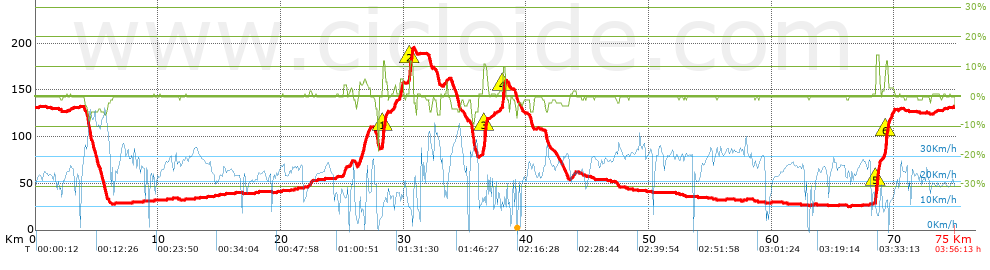
Distance in Km: 75.04
Climb in m: 368
IBP: 52 BYC

Jose_Ortiz
Author: Jose_Ortiz
229 published routes

Add to my Group or Club

 Height in m      Climb in %      Speed in Km/h      Speed < 2 Km/h

Climbs > 5%

Climbs >5% Climbs >10% Climbs >15% Climbs >20% Climbs >25%
 Steep slope of 186 m.   Average slope  Distances  Download as waypoint
1
 Km 26.777  6%  186 m
 Steep slope of 288 m.  Average slope  Distances  Download as waypoint
2
 Km 28.26  8%  38 m
3
 Km 28.299  12%  213 m
4
 Km 28.512  9%  37 m
 Steep slope of 239 m.  Average slope  Distances  Download as waypoint
5
 Km 29.722  6%  239 m
 Steep slope of 280 m.  Average slope  Distances  Download as waypoint
6
 Km 30.5  12%  280 m
 Steep slope of 380 m.  Average slope  Distances  Download as waypoint
7
 Km 36.495  6%  30 m
8
 Km 36.525  11%  265 m
9
 Km 36.79  8%  85 m
 Steep slope of 290 m.  Average slope  Distances  Download as waypoint
10
 Km 38.06  6%  36 m
11
 Km 38.095  10%  220 m
12
 Km 38.315  9%  34 m
 Steep slope of 283 m.  Average slope  Distances  Download as waypoint
13
 Km 68.511  13%  283 m
 Steep slope of 293 m.  Average slope  Distances  Download as waypoint
14
 Km 69.239  6%  36 m
15
 Km 69.275  12%  218 m
16
 Km 69.493  10%  39 m


Description of the route


Presence of ramps


 Climbs  Distance  % of the total  Speed  Your speed would be  Time  Your time would be
   15 - 30%  0  0  0  ?  0:00:00  ?
   10 - 15%  1.48  1.97  10.65  ?  0:08:20  ?
   5 - 10%  0.831  1.11  11.29  ?  0:04:25  ?
   1 - 5%  5.778  7.7  13.94  ?  0:24:52  ?
   Total*  8.089 Km  10.78 %  12.9 Km/h  ? Km/h    0:37:37 h  ? h  
 Flat
   1 - -1%  56.695 Km  75.56 %  22.52 Km/h  ? Km/h    2:31:03 h  ? h  
 Descents
   -1 - -5%  8.284  11.04  19.9  ?  0:24:59  ?
   -5 - -10%  1.905  2.54  36.67  ?  0:03:07  ?
   -10 - -15%  0.033  0.04  4.06  ?  0:00:29  ?
   -15 - -30%  0.033  0.04  1.73  ?  0:01:08  ?
   Total*  10.254 Km  13.67 %  20.7 Km/h  ? Km/h    0:29:43 h  ? h  
* The total has not necessarily coincide with the sum of the partials after correction of errors

How long would it take you?

How long would it take you to cover this route?
There are routes without a valid time information, but with your average stats you can assess the possible duration

Jose_Ortiz to cover this route you've need a time of:   3:38:23 h 
If you sign in and have a minimum of two tracks of this same modality, you can know your time for this route, calculated from your stats..


¿Cuanto consumirá tu E-BIKE?

Entra tu E-IBP (formato n,nn)

E-IBP :   X 52 = 


 Detected activity type =  ()
 Penalization due to track conditions: 47 %   ( > 50 % = MTB, < 50 % = RDB)
 Reliability of the track: E   (682/31/2/2/2/68)
 Correction level applied to the track: 7        See analyis without corrections
DIFFICULTY OF THE ROUTE
IBP = 52 BYC
According to your statistics
 Your time in motion would be: ? h
Your average speed would be: ? Km/h
 

 Total Distance: 75.04 Km
 Analysed distance: 75.04 Km
 Linear distance: 0 Km

 Cumulated positive ramps: 368.1 m  list of points info
 Cumulated negative ramps: 365.83 m
 Maximum height: 195.6 m
 Minimum height: 24.7 m
 Climbing Ratio: 4.55 %
 Descent ratio: 3.57 %
 Cumulated postive ramps per Km: 4.91 m
 Cumulated negative ramps per Km: 4.88 m

 Total time: 3:56:13 h
 Time in movement: 3:38:23 h
 According to your statistics
 Your time in motion would be: ? h  
 Stopped time: 0:17:50 h
 Maximum slope filter: ~30 %
 Minimum separation analysed: ~30 m
 Number of points: 5188   (cad. 14.46 m)
 Significant waypoints: 2099   (cad. 35.75 m / 40.46 %)

 Changes in direction per Km: 8.56
 Changes in direction > 5º por Km: 4.98
 Cumulated straight stretches: 25.285 Km
 Straight stretches per Km: 336.95 m
 Penalized slope changes: 9
 Penalized slope changes per Km: 0.12

 Average speed in total: 19.06 Km/h
 Average speed while moving: 20.62 Km/h
 According to your statistics
 Your average speed would be: ? Km/h  
 Maximum sustained speed: 50.94 Km/h


Comments

You can be the first one in commenting this route

 
My comments
:
Add comment  (Registered users)
 
Notify me answers to my comment  Do not notify answers to my comment


Share this route with a friend

Your friend will receive a message with a link to this page:
will see your email and your user name if you do it as registered user.


Write here your name (optional)

E-mail address of your friend(s). You can include various addresses separated by commas

Text or comment (optional) maximum 255 characters long, 255 Available characters

As a non registered users you need to fill-in the captcha text.
  Change image
Type the image characters.
 
 Share with a friend


Visited history

Delete history

Marked routes for review later or compare

My favorites


  Notify anomaly in this route Share in Facebook