Ruta Olesa-Serra de la Monja-Serra de la Tardana-Bosc de la Torre-Bosc de Àliga-Serra Ocata-Olesa...

MTB
MTB
Ref..: 350617
Published: 12/11/2017
Performed: 11/11/2017
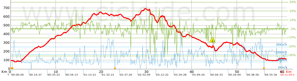
Distance in Km: 61.01
Climb in m: 1319
IBP: 92 BYC

Near ...
Abrera, Castellgali, Esparreguera, Olesa De Montserrat, Santa Maria De Vilalba

 Height in m      Climb in %      Speed in Km/h      Speed < 2 Km/h

Climbs > 5%

Climbs >5% Climbs >10% Climbs >15% Climbs >20% Climbs >25%
 Steep slope of 252 m.   Average slope  Distances  Download as waypoint
1
 Km 2.26  6%  252 m
 Steep slope of 320 m.  Average slope  Distances  Download as waypoint
2
 Km 2.796  6%  320 m
 Steep slope of 151 m.  Average slope  Distances  Download as waypoint
3
 Km 3.25  6%  151 m
 Steep slope of 293 m.  Average slope  Distances  Download as waypoint
4
 Km 3.64  5%  293 m
 Steep slope of 168 m.  Average slope  Distances  Download as waypoint
5
 Km 4.035  7%  168 m
 Steep slope of 111 m.  Average slope  Distances  Download as waypoint
6
 Km 5.07  5%  111 m
 Steep slope of 125 m.  Average slope  Distances  Download as waypoint
7
 Km 5.917  6%  125 m
 Steep slope of 432 m.  Average slope  Distances  Download as waypoint
8
 Km 8.025  6%  432 m
 Steep slope of 151 m.  Average slope  Distances  Download as waypoint
9
 Km 8.62  7%  151 m
 Steep slope of 98 m.  Average slope  Distances  Download as waypoint
10
 Km 9.558  6%  98 m
 Steep slope of 165 m.  Average slope  Distances  Download as waypoint
11
 Km 9.778  9%  165 m
 Steep slope of 312 m.  Average slope  Distances  Download as waypoint
12
 Km 11.385  6%  312 m
 Steep slope of 161 m.  Average slope  Distances  Download as waypoint
13
 Km 12.332  6%  161 m
 Steep slope of 387 m.  Average slope  Distances  Download as waypoint
14
 Km 12.68  6%  387 m
 Steep slope of 135 m.  Average slope  Distances  Download as waypoint
15
 Km 13.176  7%  135 m
 Steep slope of 218 m.  Average slope  Distances  Download as waypoint
16
 Km 13.437  6%  32 m
17
 Km 13.468  11%  108 m
18
 Km 13.576  7%  78 m
 Steep slope of 109 m.  Average slope  Distances  Download as waypoint
19
 Km 14.782  7%  109 m
 Steep slope of 277 m.  Average slope  Distances  Download as waypoint
20
 Km 15.614  6%  73 m
21
 Km 15.687  10%  135 m
22
 Km 15.821  12%  69 m
 Steep slope of 413 m.  Average slope  Distances  Download as waypoint
23
 Km 16.6  6%  413 m
 Steep slope of 206 m.  Average slope  Distances  Download as waypoint
24
 Km 17.136  7%  206 m
 Steep slope of 670 m.  Average slope  Distances  Download as waypoint
25
 Km 17.551  11%  102 m
26
 Km 17.653  8%  568 m
 Steep slope of 113 m.  Average slope  Distances  Download as waypoint
27
 Km 18.999  7%  113 m
 Steep slope of 253 m.  Average slope  Distances  Download as waypoint
28
 Km 19.363  7%  253 m
 Steep slope of 159 m.  Average slope  Distances  Download as waypoint
29
 Km 21.907  6%  159 m
 Steep slope of 316 m.  Average slope  Distances  Download as waypoint
30
 Km 26.587  6%  316 m
 Steep slope of 147 m.  Average slope  Distances  Download as waypoint
31
 Km 27.125  8%  147 m
 Steep slope of 332 m.  Average slope  Distances  Download as waypoint
32
 Km 27.428  9%  36 m
33
 Km 27.464  13%  98 m
34
 Km 27.563  8%  198 m
 Steep slope of 429 m.  Average slope  Distances  Download as waypoint
35
 Km 28.553  10%  30 m
36
 Km 28.583  11%  115 m
37
 Km 28.698  8%  284 m
 Steep slope of 147 m.  Average slope  Distances  Download as waypoint
38
 Km 29.436  5%  41 m
39
 Km 29.476  10%  106 m
 Steep slope of 418 m.  Average slope  Distances  Download as waypoint
40
 Km 32.448  6%  31 m
41
 Km 32.479  12%  215 m
42
 Km 32.694  13%  172 m
 Steep slope of 131 m.  Average slope  Distances  Download as waypoint
43
 Km 33.013  13%  131 m
 Steep slope of 94 m.  Average slope  Distances  Download as waypoint
44
 Km 33.369  12%  94 m
 Steep slope of 232 m.  Average slope  Distances  Download as waypoint
45
 Km 35.666  7%  232 m
 Steep slope of 134 m.  Average slope  Distances  Download as waypoint
46
 Km 37.29  7%  134 m
 Steep slope of 231 m.  Average slope  Distances  Download as waypoint
47
 Km 38.584  7%  231 m
 Steep slope of 61 m.  Average slope  Distances  Download as waypoint
48
 Km 44.553  20%  61 m
 Steep slope of 187 m.  Average slope  Distances  Download as waypoint
49
 Km 45.616  5%  120 m
50
 Km 45.737  12%  67 m
 Steep slope of 264 m.  Average slope  Distances  Download as waypoint
51
 Km 45.898  6%  264 m
 Steep slope of 393 m.  Average slope  Distances  Download as waypoint
52
 Km 46.554  7%  393 m
 Steep slope of 103 m.  Average slope  Distances  Download as waypoint
53
 Km 49.727  8%  103 m
 Steep slope of 130 m.  Average slope  Distances  Download as waypoint
54
 Km 52.425  5%  130 m
 Steep slope of 144 m.  Average slope  Distances  Download as waypoint
55
 Km 59.19  6%  144 m


Description of the route


Presence of ramps


 Climbs  Distance  % of the total  Speed  Your speed would be  Time  Your time would be
   15 - 30%  0.338  0.55  6.31  ?  0:03:13  ?
   10 - 15%  1.697  2.78  7.69  ?  0:13:14  ?
   5 - 10%  9.236  15.14  10.26  ?  0:54:01  ?
   1 - 5%  14.302  23.44  12.97  ?  1:06:11  ?
   Total*  25.573 Km  41.92 %  11.23 Km/h  ? Km/h    2:16:39 h  ? h  
 Flat
   1 - -1%  11.851 Km  19.43 %  18.91 Km/h  ? Km/h    0:37:36 h  ? h  
 Descents
   -1 - -5%  14.823  24.3  21.88  ?  0:40:39  ?
   -5 - -10%  5.594  9.17  19.14  ?  0:17:32  ?
   -10 - -15%  1.308  2.14  16.63  ?  0:04:43  ?
   -15 - -30%  1.857  3.04  8.98  ?  0:12:25  ?
   Total*  23.582 Km  38.65 %  18.79 Km/h  ? Km/h    1:15:19 h  ? h  
* The total has not necessarily coincide with the sum of the partials after correction of errors

How long would it take you?

How long would it take you to cover this route?
There are routes without a valid time information, but with your average stats you can assess the possible duration

PLATO PEQUEÑO to cover this route you've need a time of:   4:09:34 h 
If you sign in and have a minimum of two tracks of this same modality, you can know your time for this route, calculated from your stats..


¿Cuanto consumirá tu E-BIKE?

Entra tu E-IBP (formato n,nn)

E-IBP :   X 92 = 


 Detected activity type =  ()
 Penalization due to track conditions: 69 %   ( > 50 % = MTB, < 50 % = RDB)
 Reliability of the track: B   (1319/64/0/-/-/64)
 Correction level applied to the track: 0
DIFFICULTY OF THE ROUTE
IBP = 92 BYC
According to your statistics
 Your time in motion would be: ? h
Your average speed would be: ? Km/h
 

 Total Distance: 61.01 Km
 Analysed distance: 61.01 Km
 Linear distance: 0.02 Km

 Cumulated positive ramps: 1318.6 m  list of points info
 Cumulated negative ramps: 1302.6 m
 Maximum height: 690.8 m
 Minimum height: 83 m
 Climbing Ratio: 5.16 %
 Descent ratio: 5.52 %
 Cumulated postive ramps per Km: 21.61 m
 Cumulated negative ramps per Km: 21.35 m

 Total time: 5:11:54 h
 Time in movement: 4:09:34 h
 According to your statistics
 Your time in motion would be: ? h  
 Stopped time: 1:02:20 h
 Maximum slope filter: ~30 %
 Minimum separation analysed: ~30 m
 Number of points: 4172   (cad. 14.62 m)
 Significant waypoints: 1499   (cad. 40.7 m / 35.93 %)

 Changes in direction per Km: 10.38
 Changes in direction > 5º por Km: 7.52
 Cumulated straight stretches: 11.12 Km
 Straight stretches per Km: 182.27 m
 Penalized slope changes: 11
 Penalized slope changes per Km: 0.18

 Average speed in total: 11.74 Km/h
 Average speed while moving: 14.67 Km/h
 According to your statistics
 Your average speed would be: ? Km/h  
 Maximum sustained speed: 50.55 Km/h


Comments

You can be the first one in commenting this route

 
My comments
:
Add comment  (Registered users)
 
Notify me answers to my comment  Do not notify answers to my comment


Share this route with a friend

Your friend will receive a message with a link to this page:
will see your email and your user name if you do it as registered user.


Write here your name (optional)

E-mail address of your friend(s). You can include various addresses separated by commas

Text or comment (optional) maximum 255 characters long, 255 Available characters

As a non registered users you need to fill-in the captcha text.
  Change image
Type the image characters.
 
 Share with a friend


Visited history

Delete history

Marked routes for review later or compare

My favorites


  Notify anomaly in this route Share in Facebook