Maspuyols la Mussara Prades Siurana

Road
Road
Ref..: 345891
Published: 13/08/2017
Performed: 12/08/2017
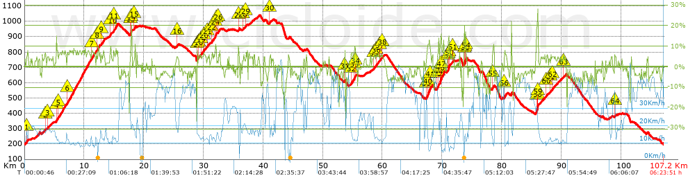
Distance in Km: 107.19
Climb in m: 2345
IBP: 148 BYC


 Height in m      Climb in %      Speed in Km/h      Speed < 2 Km/h

Climbs > 5%

Climbs >5% Climbs >10% Climbs >15% Climbs >20% Climbs >25%
 Steep slope of 276 m.   Average slope  Distances  Download as waypoint
1
 Km 0.316  6%  276 m
 Steep slope of 136 m.  Average slope  Distances  Download as waypoint
2
 Km 3.447  6%  136 m
 Steep slope of 179 m.  Average slope  Distances  Download as waypoint
3
 Km 3.813  5%  179 m
 Steep slope of 259 m.  Average slope  Distances  Download as waypoint
4
 Km 5.324  7%  259 m
 Steep slope of 1202 m.  Average slope  Distances  Download as waypoint
5
 Km 5.696  7%  1202 m
 Steep slope of 3914 m.  Average slope  Distances  Download as waypoint
6
 Km 7.148  7%  3914 m
 Steep slope of 802 m.  Average slope  Distances  Download as waypoint
7
 Km 11.237  6%  802 m
 Steep slope of 414 m.  Average slope  Distances  Download as waypoint
8
 Km 12.177  7%  414 m
 Steep slope of 497 m.  Average slope  Distances  Download as waypoint
9
 Km 12.904  6%  497 m
 Steep slope of 252 m.  Average slope  Distances  Download as waypoint
10
 Km 14.306  8%  252 m
 Steep slope of 686 m.  Average slope  Distances  Download as waypoint
11
 Km 14.916  7%  686 m
 Steep slope of 268 m.  Average slope  Distances  Download as waypoint
12
 Km 17.716  7%  35 m
13
 Km 17.752  11%  111 m
14
 Km 17.863  13%  122 m
 Steep slope of 243 m.  Average slope  Distances  Download as waypoint
15
 Km 18.381  8%  243 m
 Steep slope of 159 m.  Average slope  Distances  Download as waypoint
16
 Km 25.518  6%  159 m
 Steep slope of 173 m.  Average slope  Distances  Download as waypoint
17
 Km 28.908  5%  173 m
 Steep slope of 186 m.  Average slope  Distances  Download as waypoint
18
 Km 29.179  5%  186 m
 Steep slope of 259 m.  Average slope  Distances  Download as waypoint
19
 Km 29.532  5%  259 m
 Steep slope of 199 m.  Average slope  Distances  Download as waypoint
20
 Km 30.01  6%  199 m
 Steep slope of 306 m.  Average slope  Distances  Download as waypoint
21
 Km 30.664  5%  306 m
 Steep slope of 287 m.  Average slope  Distances  Download as waypoint
22
 Km 31.407  6%  287 m
 Steep slope of 311 m.  Average slope  Distances  Download as waypoint
23
 Km 31.903  7%  54 m
24
 Km 31.957  11%  156 m
25
 Km 32.113  8%  101 m
 Steep slope of 363 m.  Average slope  Distances  Download as waypoint
26
 Km 32.455  6%  363 m
 Steep slope of 174 m.  Average slope  Distances  Download as waypoint
27
 Km 35.825  10%  174 m
 Steep slope of 122 m.  Average slope  Distances  Download as waypoint
28
 Km 36.598  5%  122 m
 Steep slope of 217 m.  Average slope  Distances  Download as waypoint
29
 Km 37.072  6%  217 m
 Steep slope of 158 m.  Average slope  Distances  Download as waypoint
30
 Km 41.12  6%  158 m
 Steep slope of 134 m.  Average slope  Distances  Download as waypoint
31
 Km 53.658  7%  134 m
 Steep slope of 427 m.  Average slope  Distances  Download as waypoint
32
 Km 54.707  7%  427 m
 Steep slope of 338 m.  Average slope  Distances  Download as waypoint
33
 Km 55.302  11%  138 m
34
 Km 55.44  5%  200 m
 Steep slope of 130 m.  Average slope  Distances  Download as waypoint
35
 Km 58.578  6%  130 m
 Steep slope of 472 m.  Average slope  Distances  Download as waypoint
36
 Km 58.91  6%  472 m
 Steep slope of 175 m.  Average slope  Distances  Download as waypoint
37
 Km 59.598  5%  175 m
 Steep slope of 128 m.  Average slope  Distances  Download as waypoint
38
 Km 59.938  6%  128 m
 Steep slope of 833 m.  Average slope  Distances  Download as waypoint
39
 Km 67.388  8%  197 m
40
 Km 67.585  11%  381 m
41
 Km 67.966  7%  255 m
 Steep slope of 345 m.  Average slope  Distances  Download as waypoint
42
 Km 69.171  9%  35 m
43
 Km 69.207  9%  212 m
44
 Km 69.419  11%  98 m
 Steep slope of 805 m.  Average slope  Distances  Download as waypoint
45
 Km 69.642  8%  36 m
46
 Km 69.677  13%  221 m
47
 Km 69.898  9%  548 m
 Steep slope of 564 m.  Average slope  Distances  Download as waypoint
48
 Km 70.933  7%  78 m
49
 Km 71.012  12%  173 m
50
 Km 71.185  6%  313 m
 Steep slope of 131 m.  Average slope  Distances  Download as waypoint
51
 Km 71.769  5%  131 m
 Steep slope of 250 m.  Average slope  Distances  Download as waypoint
52
 Km 73.741  13%  131 m
53
 Km 73.872  16%  88 m
54
 Km 73.96  21%  31 m
 Steep slope of 254 m.  Average slope  Distances  Download as waypoint
55
 Km 78.503  8%  254 m
 Steep slope of 358 m.  Average slope  Distances  Download as waypoint
56
 Km 80.391  7%  358 m
 Steep slope of 292 m.  Average slope  Distances  Download as waypoint
57
 Km 85.846  12%  171 m
58
 Km 86.016  28%  30 m
59
 Km 86.046  28%  91 m
 Steep slope of 156 m.  Average slope  Distances  Download as waypoint
60
 Km 87.502  6%  156 m
 Steep slope of 115 m.  Average slope  Distances  Download as waypoint
61
 Km 88.202  6%  115 m
 Steep slope of 153 m.  Average slope  Distances  Download as waypoint
62
 Km 88.459  5%  153 m
 Steep slope of 111 m.  Average slope  Distances  Download as waypoint
63
 Km 90.347  5%  111 m
 Steep slope of 189 m.  Average slope  Distances  Download as waypoint
64
 Km 98.935  5%  189 m


Description of the route


Presence of ramps


 Climbs  Distance  % of the total  Speed  Your speed would be  Time  Your time would be
   15 - 30%  0.748  0.7  16.32  ?  0:02:45  ?
   10 - 15%  1.809  1.69  11.23  ?  0:09:40  ?
   5 - 10%  18.652  17.4  12.45  ?  1:29:53  ?
   1 - 5%  22.805  21.27  16.16  ?  1:24:40  ?
   Total*  44.014 Km  41.06 %  14.12 Km/h  ? Km/h    3:06:58 h  ? h  
 Flat
   1 - -1%  16.314 Km  15.22 %  22.91 Km/h  ? Km/h    0:42:44 h  ? h  
 Descents
   -1 - -5%  27.777  25.91  34.16  ?  0:48:47  ?
   -5 - -10%  15.998  14.92  38.63  ?  0:24:51  ?
   -10 - -15%  2.164  2.02  36.07  ?  0:03:36  ?
   -15 - -30%  0.924  0.86  26.39  ?  0:02:06  ?
   Total*  46.863 Km  43.72 %  35.44 Km/h  ? Km/h    1:19:20 h  ? h  
* The total has not necessarily coincide with the sum of the partials after correction of errors

How long would it take you?

How long would it take you to cover this route?
There are routes without a valid time information, but with your average stats you can assess the possible duration

Jose A .MC37 to cover this route you've need a time of:   5:09:02 h 
If you sign in and have a minimum of two tracks of this same modality, you can know your time for this route, calculated from your stats..


¿Cuanto consumirá tu E-BIKE?

Entra tu E-IBP (formato n,nn)

E-IBP :   X 148 = 


 Detected activity type =  ()
 Penalization due to track conditions: 46 %   ( > 50 % = MTB, < 50 % = RDB)
 Reliability of the track: A   (2345/80/0/-/-/80)
 Correction level applied to the track: 0
DIFFICULTY OF THE ROUTE
IBP = 148 BYC
According to your statistics
 Your time in motion would be: ? h
Your average speed would be: ? Km/h
 

 Total Distance: 107.19 Km
 Analysed distance: 107.19 Km
 Linear distance: 0.01 Km

 Cumulated positive ramps: 2344.9 m  list of points info
 Cumulated negative ramps: 2336.9 m
 Maximum height: 1039.1 m
 Minimum height: 196 m
 Climbing Ratio: 5.33 %
 Descent ratio: 4.99 %
 Cumulated postive ramps per Km: 21.88 m
 Cumulated negative ramps per Km: 21.8 m

 Total time: 6:23:51 h
 Time in movement: 5:09:02 h
 According to your statistics
 Your time in motion would be: ? h  
 Stopped time: 1:14:49 h
 Maximum slope filter: ~30 %
 Minimum separation analysed: ~30 m
 Number of points: 4579   (cad. 23.41 m)
 Significant waypoints: 2357   (cad. 45.48 m / 51.47 %)

 Changes in direction per Km: 6.92
 Changes in direction > 5º por Km: 5.22
 Cumulated straight stretches: 27.483 Km
 Straight stretches per Km: 256.4 m
 Penalized slope changes: 19
 Penalized slope changes per Km: 0.177

 Average speed in total: 16.76 Km/h
 Average speed while moving: 20.81 Km/h
 According to your statistics
 Your average speed would be: ? Km/h  
 Maximum sustained speed: 59.66 Km/h


Comments

You can be the first one in commenting this route

 
My comments
:
Add comment  (Registered users)
 
Notify me answers to my comment  Do not notify answers to my comment


Share this route with a friend

Your friend will receive a message with a link to this page:
will see your email and your user name if you do it as registered user.


Write here your name (optional)

E-mail address of your friend(s). You can include various addresses separated by commas

Text or comment (optional) maximum 255 characters long, 255 Available characters

As a non registered users you need to fill-in the captcha text.
  Change image
Type the image characters.
 
 Share with a friend


Visited history

Delete history

Marked routes for review later or compare

My favorites


  Notify anomaly in this route Share in Facebook