Brm 400 Km. Linares - Ruidera - Linares Gps

Road
Road
Ref..: 344552
Published: 04/06/2017
Performed: 04/06/2017
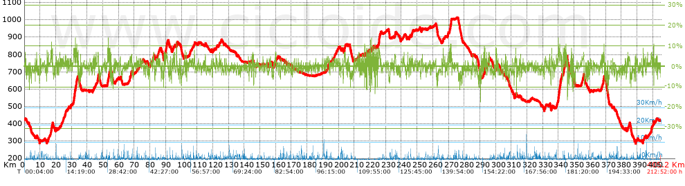
Distance in Km: 405.18
Climb in m: 4731
IBP: 416 BYC

ercapi
Author: ercapi
749 published routes

Add to my Group or Club

 Height in m      Climb in %      Speed in Km/h      Speed < 2 Km/h

Climbs > 5%

Climbs >5% Climbs >10% Climbs >15% Climbs >20% Climbs >25%
 Steep slope of 202 m.   Average slope  Distances  Download as waypoint
1
 Km 14.369  7%  202 m
 Steep slope of 192 m.  Average slope  Distances  Download as waypoint
2
 Km 17.327  8%  192 m
 Steep slope of 152 m.  Average slope  Distances  Download as waypoint
3
 Km 17.887  7%  152 m
 Steep slope of 352 m.  Average slope  Distances  Download as waypoint
4
 Km 31.714  6%  352 m
 Steep slope of 153 m.  Average slope  Distances  Download as waypoint
5
 Km 32.24  11%  153 m
 Steep slope of 191 m.  Average slope  Distances  Download as waypoint
6
 Km 32.72  8%  191 m
 Steep slope of 257 m.  Average slope  Distances  Download as waypoint
7
 Km 33.127  7%  257 m
 Steep slope of 143 m.  Average slope  Distances  Download as waypoint
8
 Km 44.272  6%  143 m
 Steep slope of 496 m.  Average slope  Distances  Download as waypoint
9
 Km 46.65  7%  496 m
 Steep slope of 396 m.  Average slope  Distances  Download as waypoint
10
 Km 53.013  6%  396 m
 Steep slope of 298 m.  Average slope  Distances  Download as waypoint
11
 Km 53.84  8%  298 m
 Steep slope of 280 m.  Average slope  Distances  Download as waypoint
12
 Km 82.111  5%  280 m
 Steep slope of 167 m.  Average slope  Distances  Download as waypoint
13
 Km 88.939  6%  167 m
 Steep slope of 175 m.  Average slope  Distances  Download as waypoint
14
 Km 90.357  6%  175 m
 Steep slope of 290 m.  Average slope  Distances  Download as waypoint
15
 Km 96.949  8%  290 m
 Steep slope of 128 m.  Average slope  Distances  Download as waypoint
16
 Km 108.335  6%  128 m
 Steep slope of 242 m.  Average slope  Distances  Download as waypoint
17
 Km 204.029  5%  242 m
 Steep slope of 192 m.  Average slope  Distances  Download as waypoint
18
 Km 216.723  10%  192 m
 Steep slope of 131 m.  Average slope  Distances  Download as waypoint
19
 Km 219.911  7%  131 m
 Steep slope of 137 m.  Average slope  Distances  Download as waypoint
20
 Km 221.672  9%  137 m
 Steep slope of 210 m.  Average slope  Distances  Download as waypoint
21
 Km 225.709  8%  210 m
 Steep slope of 308 m.  Average slope  Distances  Download as waypoint
22
 Km 235.843  5%  308 m
 Steep slope of 136 m.  Average slope  Distances  Download as waypoint
23
 Km 266.526  7%  136 m
 Steep slope of 175 m.  Average slope  Distances  Download as waypoint
24
 Km 269.651  7%  175 m
 Steep slope of 138 m.  Average slope  Distances  Download as waypoint
25
 Km 270.623  7%  138 m
 Steep slope of 737 m.  Average slope  Distances  Download as waypoint
26
 Km 271.044  7%  737 m
 Steep slope of 132 m.  Average slope  Distances  Download as waypoint
27
 Km 292.288  8%  132 m
 Steep slope of 135 m.  Average slope  Distances  Download as waypoint
28
 Km 293.268  10%  135 m
 Steep slope of 202 m.  Average slope  Distances  Download as waypoint
29
 Km 300.454  5%  202 m
 Steep slope of 143 m.  Average slope  Distances  Download as waypoint
30
 Km 335.659  8%  143 m
 Steep slope of 254 m.  Average slope  Distances  Download as waypoint
31
 Km 339.855  9%  254 m
 Steep slope of 278 m.  Average slope  Distances  Download as waypoint
32
 Km 340.345  7%  278 m
 Steep slope of 707 m.  Average slope  Distances  Download as waypoint
33
 Km 340.797  8%  707 m
 Steep slope of 315 m.  Average slope  Distances  Download as waypoint
34
 Km 343.14  6%  315 m
 Steep slope of 242 m.  Average slope  Distances  Download as waypoint
35
 Km 344.036  7%  242 m
 Steep slope of 345 m.  Average slope  Distances  Download as waypoint
36
 Km 344.498  7%  345 m
 Steep slope of 145 m.  Average slope  Distances  Download as waypoint
37
 Km 345.459  6%  145 m
 Steep slope of 220 m.  Average slope  Distances  Download as waypoint
38
 Km 368.464  7%  220 m
 Steep slope of 257 m.  Average slope  Distances  Download as waypoint
39
 Km 368.852  9%  257 m
 Steep slope of 167 m.  Average slope  Distances  Download as waypoint
40
 Km 389.28  7%  167 m
 Steep slope of 168 m.  Average slope  Distances  Download as waypoint
41
 Km 393.856  8%  168 m
 Steep slope of 247 m.  Average slope  Distances  Download as waypoint
42
 Km 399.018  6%  247 m
 Steep slope of 241 m.  Average slope  Distances  Download as waypoint
43
 Km 400.411  8%  241 m


Description of the route


Linares minero. Vista nocturna


Lagunas de Ruidera


Plaza de Almagro


Lagunas de ruidera


Esquema general de las Lagunas de Ruidera


Vista aérea de las Lagunas de Ruidera


Plaza de Villanueva de los Infantes (Ciudad Real)


Presence of ramps


 Climbs  Distance  % of the total  Speed  Your speed would be  Time  Your time would be
   15 - 30%  0.088  0.02  0  ?  0:00:00  ?
   10 - 15%  1.582  0.39  5.93  ?  0:16:00  ?
   5 - 10%  18.395  4.54  4.97  ?  3:42:00  ?
   1 - 5%  122.637  30.27  4.06  ?  30:11:00  ?
   Total*  142.703 Km  35.22 %  4.18 Km/h  ? Km/h    34:09:00 h  ? h  
 Flat
   1 - -1%  119.388 Km  29.47 %  3.77 Km/h  ? Km/h    31:41:00 h  ? h  
 Descents
   -1 - -5%  120.207  29.67  3.28  ?  36:39:00  ?
   -5 - -10%  20.816  5.14  2.74  ?  7:36:00  ?
   -10 - -15%  1.814  0.45  3.2  ?  0:34:00  ?
   -15 - -30%  0.254  0.06  2.54  ?  0:06:00  ?
   Total*  143.091 Km  35.32 %  3.19 Km/h  ? Km/h    44:55:00 h  ? h  
* The total has not necessarily coincide with the sum of the partials after correction of errors

How long would it take you?

How long would it take you to cover this route?
There are routes without a valid time information, but with your average stats you can assess the possible duration

ercapi to cover this route you've need a time of:   110:45:00 h 
If you sign in and have a minimum of two tracks of this same modality, you can know your time for this route, calculated from your stats..


¿Cuanto consumirá tu E-BIKE?

Entra tu E-IBP (formato n,nn)

E-IBP :   X 416 = 


 Detected activity type =  ()
 Penalization due to track conditions: 42 %   ( > 50 % = MTB, < 50 % = RDB)
 Reliability of the track: C   (4731/55/0/-/-/55)
 Correction level applied to the track: 0
DIFFICULTY OF THE ROUTE
IBP = 416 BYC
According to your statistics
 Your time in motion would be: ? h
Your average speed would be: ? Km/h
 

 Total Distance: 405.18 Km
 Analysed distance: 405.18 Km
 Linear distance: 1.11 Km

 Cumulated positive ramps: 4731 m  list of points info
 Cumulated negative ramps: 4723 m
 Maximum height: 1013 m
 Minimum height: 287 m
 Climbing Ratio: 3.32 %
 Descent ratio: 3.3 %
 Cumulated postive ramps per Km: 11.68 m
 Cumulated negative ramps per Km: 11.66 m

 Total time: 212:52:00 h
 Time in movement: 110:45:00 h
 According to your statistics
 Your time in motion would be: ? h  
 Stopped time: 102:07:00 h
 Maximum slope filter: ~30 %
 Minimum separation analysed: ~30 m
 Number of points: 12774   (cad. 31.72 m)
 Significant waypoints: 7016   (cad. 57.75 m / 54.92 %)

 Changes in direction per Km: 7.22
 Changes in direction > 5º por Km: 1.87
 Cumulated straight stretches: 208.489 Km
 Straight stretches per Km: 514.56 m
 Penalized slope changes: 48
 Penalized slope changes per Km: 0.118

 Average speed in total: 1.9 Km/h
 Average speed while moving: 3.66 Km/h
 According to your statistics
 Your average speed would be: ? Km/h  
 Maximum sustained speed: 7.03 Km/h


Comments

You can be the first one in commenting this route

 
My comments
:
Add comment  (Registered users)
 
Notify me answers to my comment  Do not notify answers to my comment


Share this route with a friend

Your friend will receive a message with a link to this page:
will see your email and your user name if you do it as registered user.


Write here your name (optional)

E-mail address of your friend(s). You can include various addresses separated by commas

Text or comment (optional) maximum 255 characters long, 255 Available characters

As a non registered users you need to fill-in the captcha text.
  Change image
Type the image characters.
 
 Share with a friend


Visited history

Delete history

Marked routes for review later or compare

My favorites


  Notify anomaly in this route Share in Facebook