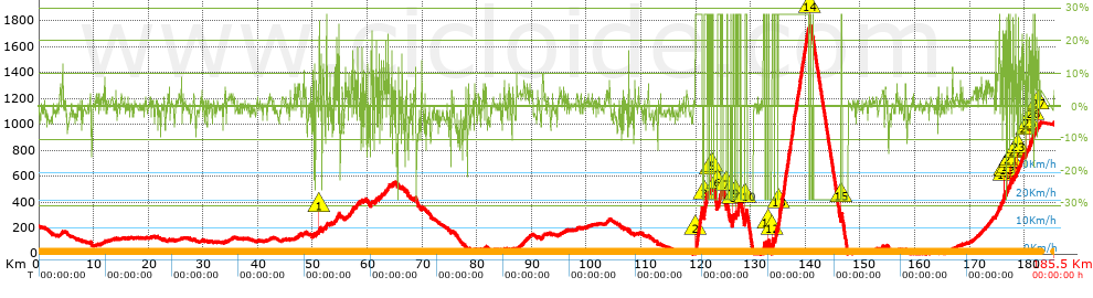
Volta CAT 2017 - E5 - Valls - Lo Port Tortosa

Road
Ref..: 343241
Published: 17/03/2017
Performed: 29/11/1999
Distance in Km: 182.88
Climb in m: 6975
IBP: 533 BYC
 Not from STRAVA
Near ...
Vallmoll, Valls
Vallmoll, Valls

This route belongs to a multi-day journey 7 days documented with 7 independent routes
You can download the tracks of this multi-day route from each of the associated stages .| Day or stage | One day stage | Distance | Climb in | IBP |
| Day 1 | 343237 Volta CAT 2017 - E1 - Calella - Calella | 179 Km | 3044 m | 212 |
| Day 2 | 343238 Volta CAT 2017 - E2 - Banyoles - Banyoles | 41 Km | 423 m | 26 |
| Day 3 | 343239 Volta CAT 2017 - E3 - Mataro - La Molina | 189 Km | 4467 m | 299 |
| Day 4 | 343240 Volta CAT 2017 - E4 - Llivia - Igualada | 195 Km | 2599 m | 216 |
| Day 5 | 343241 Volta CAT 2017 - E5 - Valls - Lo Port Tortosa (This) | 183 Km | 6174 m | 476 |
| Day 6 | 343242 Volta CAT 2017 - E6 - Tortosa - Reus | 190 Km | 3325 m | 233 |
| Day 7 | 343243 Volta CAT 2017 - E7 - Barcelona - Barcelona | 139 Km | 1543 m | 132 |
| Total 7 days | 1116 Km | 21575 m | 228 / d�a |


 list of points info

