Castiñeiras - Cabo Home y vuelta

MTB
MTB
Ref..: 342529
Published: 27/01/2017
Performed: 15/01/2017
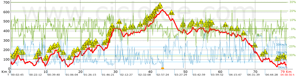
Distance in Km: 79.03
Climb in m: 2252
IBP: 169 BYC

Near ...
Aldan (Cangas), Coiro (San Salvador), Donon (Hio-Cangas), Espiñeira (Aldan - Cangas), Espirito Santo, O (Coiro), Forte, O (Coiro)

 Height in m      Climb in %      Speed in Km/h      Speed < 2 Km/h

Climbs > 5%

Climbs >5% Climbs >10% Climbs >15% Climbs >20% Climbs >25%
 Steep slope of 180 m.   Average slope  Distances  Download as waypoint
1
 Km 0.102  9%  180 m
 Steep slope of 100 m.  Average slope  Distances  Download as waypoint
2
 Km 0.705  7%  100 m
 Steep slope of 281 m.  Average slope  Distances  Download as waypoint
3
 Km 1.026  6%  34 m
4
 Km 1.06  14%  99 m
5
 Km 1.159  6%  148 m
 Steep slope of 132 m.  Average slope  Distances  Download as waypoint
6
 Km 1.41  5%  132 m
 Steep slope of 402 m.  Average slope  Distances  Download as waypoint
7
 Km 1.648  7%  136 m
8
 Km 1.784  12%  201 m
9
 Km 1.986  11%  65 m
 Steep slope of 140 m.  Average slope  Distances  Download as waypoint
10
 Km 3.037  7%  140 m
 Steep slope of 140 m.  Average slope  Distances  Download as waypoint
11
 Km 3.498  8%  140 m
 Steep slope of 404 m.  Average slope  Distances  Download as waypoint
12
 Km 7.24  9%  404 m
 Steep slope of 238 m.  Average slope  Distances  Download as waypoint
13
 Km 7.883  17%  99 m
14
 Km 7.982  11%  36 m
15
 Km 8.019  10%  103 m
 Steep slope of 202 m.  Average slope  Distances  Download as waypoint
16
 Km 9.948  6%  202 m
 Steep slope of 652 m.  Average slope  Distances  Download as waypoint
17
 Km 10.257  9%  652 m
 Steep slope of 336 m.  Average slope  Distances  Download as waypoint
18
 Km 11.043  8%  336 m
 Steep slope of 93 m.  Average slope  Distances  Download as waypoint
19
 Km 11.519  6%  93 m
 Steep slope of 105 m.  Average slope  Distances  Download as waypoint
20
 Km 12.28  6%  105 m
 Steep slope of 279 m.  Average slope  Distances  Download as waypoint
21
 Km 12.532  7%  68 m
22
 Km 12.6  14%  211 m
 Steep slope of 110 m.  Average slope  Distances  Download as waypoint
23
 Km 13.488  9%  110 m
 Steep slope of 174 m.  Average slope  Distances  Download as waypoint
24
 Km 13.992  8%  174 m
 Steep slope of 107 m.  Average slope  Distances  Download as waypoint
25
 Km 15.036  10%  107 m
 Steep slope of 148 m.  Average slope  Distances  Download as waypoint
26
 Km 16.74  5%  148 m
 Steep slope of 607 m.  Average slope  Distances  Download as waypoint
27
 Km 17.811  12%  310 m
28
 Km 18.121  9%  297 m
 Steep slope of 687 m.  Average slope  Distances  Download as waypoint
29
 Km 19.178  7%  687 m
 Steep slope of 243 m.  Average slope  Distances  Download as waypoint
30
 Km 20.673  7%  243 m
 Steep slope of 307 m.  Average slope  Distances  Download as waypoint
31
 Km 21.145  7%  307 m
 Steep slope of 253 m.  Average slope  Distances  Download as waypoint
32
 Km 21.654  8%  253 m
 Steep slope of 168 m.  Average slope  Distances  Download as waypoint
33
 Km 22.281  8%  63 m
34
 Km 22.344  13%  105 m
 Steep slope of 111 m.  Average slope  Distances  Download as waypoint
35
 Km 23.149  13%  111 m
 Steep slope of 273 m.  Average slope  Distances  Download as waypoint
36
 Km 23.493  7%  273 m
 Steep slope of 130 m.  Average slope  Distances  Download as waypoint
37
 Km 24  6%  130 m
 Steep slope of 313 m.  Average slope  Distances  Download as waypoint
38
 Km 24.385  7%  313 m
 Steep slope of 401 m.  Average slope  Distances  Download as waypoint
39
 Km 26.768  6%  401 m
 Steep slope of 1070 m.  Average slope  Distances  Download as waypoint
40
 Km 27.528  6%  123 m
41
 Km 27.65  13%  104 m
42
 Km 27.754  12%  375 m
43
 Km 28.129  10%  167 m
44
 Km 28.296  16%  102 m
45
 Km 28.398  10%  199 m
 Steep slope of 902 m.  Average slope  Distances  Download as waypoint
46
 Km 28.781  6%  33 m
47
 Km 28.814  13%  287 m
48
 Km 29.101  8%  582 m
 Steep slope of 101 m.  Average slope  Distances  Download as waypoint
49
 Km 31.118  8%  101 m
 Steep slope of 199 m.  Average slope  Distances  Download as waypoint
50
 Km 32.443  8%  199 m
 Steep slope of 238 m.  Average slope  Distances  Download as waypoint
51
 Km 32.746  5%  238 m
 Steep slope of 137 m.  Average slope  Distances  Download as waypoint
52
 Km 34.23  13%  137 m
 Steep slope of 197 m.  Average slope  Distances  Download as waypoint
53
 Km 35.012  9%  197 m
 Steep slope of 239 m.  Average slope  Distances  Download as waypoint
54
 Km 37.068  6%  239 m
 Steep slope of 307 m.  Average slope  Distances  Download as waypoint
55
 Km 38.346  7%  271 m
56
 Km 38.617  21%  36 m
 Steep slope of 173 m.  Average slope  Distances  Download as waypoint
57
 Km 38.797  7%  173 m
 Steep slope of 102 m.  Average slope  Distances  Download as waypoint
58
 Km 39.075  15%  102 m
 Steep slope of 262 m.  Average slope  Distances  Download as waypoint
59
 Km 39.6  7%  262 m
 Steep slope of 97 m.  Average slope  Distances  Download as waypoint
60
 Km 39.967  7%  97 m
 Steep slope of 136 m.  Average slope  Distances  Download as waypoint
61
 Km 40.449  11%  136 m
 Steep slope of 441 m.  Average slope  Distances  Download as waypoint
62
 Km 40.807  7%  74 m
63
 Km 40.881  14%  198 m
64
 Km 41.079  9%  169 m
 Steep slope of 301 m.  Average slope  Distances  Download as waypoint
65
 Km 41.623  7%  301 m
 Steep slope of 149 m.  Average slope  Distances  Download as waypoint
66
 Km 42.463  6%  149 m
 Steep slope of 264 m.  Average slope  Distances  Download as waypoint
67
 Km 42.804  7%  264 m
 Steep slope of 177 m.  Average slope  Distances  Download as waypoint
68
 Km 46.052  7%  177 m
 Steep slope of 243 m.  Average slope  Distances  Download as waypoint
69
 Km 49.224  10%  171 m
70
 Km 49.395  14%  72 m
 Steep slope of 227 m.  Average slope  Distances  Download as waypoint
71
 Km 51.294  6%  227 m
 Steep slope of 374 m.  Average slope  Distances  Download as waypoint
72
 Km 51.774  10%  183 m
73
 Km 51.957  10%  191 m
 Steep slope of 106 m.  Average slope  Distances  Download as waypoint
74
 Km 53.391  16%  106 m
 Steep slope of 164 m.  Average slope  Distances  Download as waypoint
75
 Km 54.581  8%  164 m
 Steep slope of 153 m.  Average slope  Distances  Download as waypoint
76
 Km 55.806  15%  104 m
77
 Km 55.91  6%  49 m
 Steep slope of 199 m.  Average slope  Distances  Download as waypoint
78
 Km 56.438  13%  167 m
79
 Km 56.605  6%  32 m
 Steep slope of 343 m.  Average slope  Distances  Download as waypoint
80
 Km 56.847  11%  106 m
81
 Km 56.953  9%  126 m
82
 Km 57.08  17%  111 m
 Steep slope of 195 m.  Average slope  Distances  Download as waypoint
83
 Km 57.549  5%  195 m
 Steep slope of 103 m.  Average slope  Distances  Download as waypoint
84
 Km 61.447  5%  103 m
 Steep slope of 274 m.  Average slope  Distances  Download as waypoint
85
 Km 63.273  9%  274 m
 Steep slope of 244 m.  Average slope  Distances  Download as waypoint
86
 Km 64.781  5%  38 m
87
 Km 64.819  10%  101 m
88
 Km 64.92  9%  105 m
 Steep slope of 380 m.  Average slope  Distances  Download as waypoint
89
 Km 66.695  6%  380 m
 Steep slope of 135 m.  Average slope  Distances  Download as waypoint
90
 Km 69.889  12%  135 m
 Steep slope of 331 m.  Average slope  Distances  Download as waypoint
91
 Km 72.037  8%  331 m
 Steep slope of 170 m.  Average slope  Distances  Download as waypoint
92
 Km 72.853  7%  170 m
 Steep slope of 178 m.  Average slope  Distances  Download as waypoint
93
 Km 76.333  13%  103 m
94
 Km 76.436  7%  75 m
 Steep slope of 104 m.  Average slope  Distances  Download as waypoint
95
 Km 77.254  12%  104 m
 Steep slope of 102 m.  Average slope  Distances  Download as waypoint
96
 Km 78.13  5%  102 m
 Steep slope of 127 m.  Average slope  Distances  Download as waypoint
97
 Km 78.802  7%  127 m


Description of the route


Presence of ramps


 Climbs  Distance  % of the total  Speed  Your speed would be  Time  Your time would be
   15 - 30%  1.677  2.12  9.58  ?  0:10:30  ?
   10 - 15%  4.37  5.53  10.14  ?  0:25:52  ?
   5 - 10%  14.022  17.74  11.39  ?  1:13:51  ?
   1 - 5%  13.91  17.6  15.48  ?  0:53:54  ?
   Total*  33.979 Km  42.99 %  12.42 Km/h  ? Km/h    2:44:07 h  ? h  
 Flat
   1 - -1%  11.538 Km  14.6 %  18.69 Km/h  ? Km/h    0:37:02 h  ? h  
 Descents
   -1 - -5%  13.831  17.5  24.24  ?  0:34:14  ?
   -5 - -10%  13.869  17.55  27.11  ?  0:30:42  ?
   -10 - -15%  3.997  5.06  23.9  ?  0:10:02  ?
   -15 - -30%  1.817  2.3  19.13  ?  0:05:42  ?
   Total*  33.514 Km  42.41 %  24.93 Km/h  ? Km/h    1:20:40 h  ? h  
* The total has not necessarily coincide with the sum of the partials after correction of errors

How long would it take you?

How long would it take you to cover this route?
There are routes without a valid time information, but with your average stats you can assess the possible duration

Ramón Mella to cover this route you've need a time of:   4:41:49 h 
If you sign in and have a minimum of two tracks of this same modality, you can know your time for this route, calculated from your stats..


¿Cuanto consumirá tu E-BIKE?

Entra tu E-IBP (formato n,nn)

E-IBP :   X 169 = 


 Detected activity type =  ()
 Penalization due to track conditions: 79 %   ( > 50 % = MTB, < 50 % = RDB)
 Reliability of the track: B   (2256/59/0/-/-/59)
 Correction level applied to the track: 0
DIFFICULTY OF THE ROUTE
IBP = 169 BYC
According to your statistics
 Your time in motion would be: ? h
Your average speed would be: ? Km/h
 

 Total Distance: 79.03 Km
 Analysed distance: 79.03 Km
 Linear distance: 0 Km

 Cumulated positive ramps: 2252.42 m  list of points info
 Cumulated negative ramps: 2280.5 m
 Maximum height: 627 m
 Minimum height: 24 m
 Climbing Ratio: 6.63 %
 Descent ratio: 6.8 %
 Cumulated postive ramps per Km: 28.5 m
 Cumulated negative ramps per Km: 28.86 m

 Total time: 4:58:56 h
 Time in movement: 4:41:49 h
 According to your statistics
 Your time in motion would be: ? h  
 Stopped time: 0:17:07 h
 Maximum slope filter: ~30 %
 Minimum separation analysed: ~30 m
 Number of points: 5177   (cad. 15.27 m)
 Significant waypoints: 2099   (cad. 37.65 m / 40.54 %)

 Changes in direction per Km: 11.3
 Changes in direction > 5º por Km: 8.19
 Cumulated straight stretches: 12.29 Km
 Straight stretches per Km: 155.51 m
 Penalized slope changes: 19
 Penalized slope changes per Km: 0.24

 Average speed in total: 15.86 Km/h
 Average speed while moving: 16.83 Km/h
 According to your statistics
 Your average speed would be: ? Km/h  
 Maximum sustained speed: 52.67 Km/h


Comments

You can be the first one in commenting this route

 
My comments
:
Add comment  (Registered users)
 
Notify me answers to my comment  Do not notify answers to my comment


Share this route with a friend

Your friend will receive a message with a link to this page:
will see your email and your user name if you do it as registered user.


Write here your name (optional)

E-mail address of your friend(s). You can include various addresses separated by commas

Text or comment (optional) maximum 255 characters long, 255 Available characters

As a non registered users you need to fill-in the captcha text.
  Change image
Type the image characters.
 
 Share with a friend


Visited history

Delete history

Marked routes for review later or compare

My favorites


  Notify anomaly in this route Share in Facebook